Outer Banks facts for kids
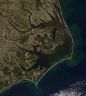
The Outer Banks (often called OBX) are a long string of islands and sandbars. They stretch about 200 miles (320 km) off the coast of North Carolina and southeastern Virginia. These islands act like a natural wall, separating the Atlantic Ocean from large bodies of water called sounds. These sounds include Currituck Sound, Albemarle Sound, and Pamlico Sound.
The Outer Banks are a very popular place for tourists to visit. People love the wide, open beaches and the beautiful Cape Hatteras National Seashore. This area is also important for nature, with many different kinds of plants and animals. Beach grasses and shrubs help keep the land from washing away.
This area has a rich history. It was one of the first places where Europeans tried to settle in the United States. The famous English Roanoke Colony disappeared from Roanoke Island in 1587. This was also where Virginia Dare, the first English person born in the Americas, was born. Hundreds of shipwrecks have happened here, earning the surrounding seas the nickname Graveyard of the Atlantic.
The Outer Banks is also famous for aviation history. The Wright brothers made their first flight in a controlled, powered airplane here. This happened on December 17, 1903, at Kill Devil Hills. Over the last 100 years, the region has become a major spot for beach tourism.
The Outer Banks faces challenges from sea level rise and coastal erosion. This means the ocean is slowly taking away parts of the land. In some places, the sea level rose 5 inches (13 cm) in just four years (2011-2015). Strong tropical storms like Hurricane Irene in 2011 have also damaged buildings and roads.
Contents
What are the Outer Banks?
The name "Outer Banks" refers to the islands, sandbars, and sandy points from Ocracoke northward. People often use the abbreviation OBX in tourism ads. Recently, beaches south of Cape Lookout have started calling themselves the "Southern Outer Banks" (SOBX). This area includes the Crystal Coast beaches of Bogue Banks. The term Inner Banks (IBX) is a newer name for the mainland towns along the Albemarle and Pamlico Sounds.
Geography of the Islands
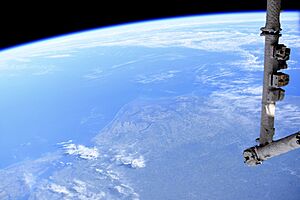
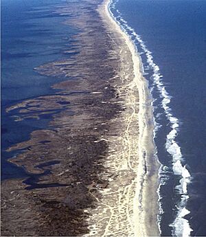
Millions of years ago, a tall ridge of sand dunes formed the barrier islands that make up the Outer Banks. These islands protect the mainland from strong ocean waves and storms. The Outer Banks is a chain of peninsulas and islands that separate the Atlantic Ocean from mainland North Carolina.
From north to south, the largest islands include:
- Bodie Island (now a peninsula connected to the mainland)
- Pea Island
- Hatteras Island
- Ocracoke Island
- Portsmouth Island
- Core Banks
The number and shape of these islands change over time. Strong storms can create new channels (inlets) through the islands. Over time, sand can fill in older inlets, connecting islands that were once separate.
The Outer Banks stretch from Sandbridge in Virginia Beach, Virginia, down the North Carolina coast. Some people say the Outer Banks ends at Cape Fear. Others say it ends at Cape Lookout. Most agree it includes Cape Hatteras and the coastal areas of four counties: Currituck, Dare, Hyde, and Carteret.
The northern part of the Outer Banks, from Oregon Inlet northward, is actually connected to the mainland. This is because old inlets have closed. It is separated from the rest of the mainland by the Currituck Sound and the Intracoastal Waterway. Some communities, like Carova Beach, can only be reached by four-wheel drive vehicles. North Carolina State Highway 12 is the main road connecting most Outer Banks communities.
The Outer Banks are not protected by offshore coral reefs. This means they often experience a lot of beach erosion during big storms. Because they stick out into the Atlantic, they are the most hurricane-prone area north of Florida.
For example, Hurricane Isabel in 2003 cut Hatteras Island in half. It created a 2,000-foot (600 m) wide channel called Isabel Inlet. This channel was later filled in with sand. In 2011, Hurricane Irene cut off the island again.
Three main bridges connect the Outer Banks to the mainland. The Wright Memorial Bridge connects Point Harbor to Kitty Hawk. The William B. Umstead Bridge and the Virginia Dare Memorial Bridge connect Manns Harbor to Roanoke Island. At Whalebone Junction, the main highways of the Outer Banks (NC 12, US 158, and US 64) all meet.
Several ferries also serve the Outer Banks. These ferries are run by the North Carolina Department of Transportation Ferry Division. They connect places like Knotts Island, Hatteras, Ocracoke, Swan Quarter, and Cedar Island.
Plants and Animals
Unique Plants
The Outer Banks has many different kinds of plants. It's the northernmost place where some southern plants, like wild scrub palms, can grow. In the northern Outer Banks, you'll find sea grasses and other beach plants. You can also see wax myrtles, bays, and pine trees with Spanish moss-covered live oaks.
Some unique plants like Yucca aloifolia and Yucca gloriosa grow wild on the beach. Small dwarf palmettos used to grow all over the Outer Banks. You can still find them growing naturally on Monkey Island.
Further south, from Cape Hatteras National Seashore onward, you'll find dwarf palmettos and other Yucca plants. You can also see Cabbage Palmetto (Sabal palmetto), which is native to the southern Outer Banks. Many different native plants can be seen at the Elizabethan Gardens in Manteo on Roanoke Island.
The Outer Banks is also home to Yaupon Holly (Ilex vomitoria). Native Americans used to roast its leaves to make a drink with caffeine called black drink. The Outer Banks might be one of the few places where people still drink it.
Wild Animals
The islands are home to herds of wild horses, often called "banker ponies". Local stories say these horses are descended from Spanish mustangs. These horses supposedly swam ashore centuries ago after shipwrecks. You can find these horse populations on Ocracoke Island, Shackleford Banks, Currituck Banks, and in the Rachel Carson Estuarine Sanctuary.
Climate and Weather
The Outer Banks has a humid subtropical climate. This means it has hot, humid summers and mild winters. Its unique location, sticking out into the Atlantic Ocean, makes it prone to hurricanes and other ocean storms.
Winters are usually milder than inland areas. Highs are typically in the low 50s Fahrenheit (10-12°C). Summers are warm, with highs in the upper 80s Fahrenheit (30-32°C). Spring and fall are generally mild. The ocean helps keep the temperatures more moderate, making summers a bit cooler and winters a bit warmer than inland.
Snow is rare, but it can happen. The Outer Banks is also where many "nor'easters" (strong winter storms) form.
As mentioned before, the Outer Banks is very vulnerable to sea level rise and coastal erosion. This is made worse by climate change. In some spots, sea levels rose 5 inches (13 cm) from 2011 to 2015. Parts of Hatteras Island have lost a lot of their width. Strong storms like Hurricane Irene in 2011 have already caused a lot of damage.
History of the Outer Banks
The Outer Banks has a very special culture on the East Coast of the United States. Before Europeans arrived, Native American tribes lived here. These included the Algonquin-speaking Chowanoke, Secotan, and Poteskeet people. They often fished on the barrier islands in the summer and lived on Roanoke Island or the mainland in winter.
European explorers in the 1500s met friendly Native Americans on Hatteras Island and the Outer Banks. They noted how welcoming these natives were. Sadly, European diseases and movement to the mainland caused the Native population to decline. The most famous event was the English attempt to settle Roanoke starting in 1584.
Before bridges were built in the 1930s, people could only travel by boat. This kept the islands isolated from the mainland. This isolation helped preserve the unique maritime culture and the special Outer Banks accent, or brogue. This accent sounds more like an English accent than an American one. Many "bankers" (people from the Outer Banks) have been mistaken for being from England or Ireland. The accent is strongest the further south you go, especially on Ocracoke Island and Harkers Island.
Some Outer Banks residents, called "wreckers," made money by salvaging items from wrecked ships. Some even tricked ships into crashing. They would tie lanterns to horses' necks and walk them along the beach. The bobbing lights would look like a ship in clear water, leading unsuspecting captains to steer their ships onto the shore. Ocracoke was the last hiding place of the famous pirate Edward Teach, better known as Blackbeard. He was killed there on November 22, 1718, in a fierce battle.
Economy and Jobs
The main jobs in the Outer Banks include commercial fishing, boat building, and tourism. Since the 1990s, tourism has grown a lot. This means more jobs are now in services, like hotels and restaurants.
Fishing Industry
Fishing has been important in the Outer Banks since the late 1600s. After pirates were no longer a problem, local settlers relied on fishing for their living. In the mid-1800s, large-scale commercial fishing began. This was helped by the building of the Albemarle and Chesapeake Canal, which made shipping fish easier. Saltwater fishing became a major industry and helped the Outer Banks become a popular tourist spot. Today, many tourists visit just to go fishing. Fishermen (or anglers) use many different methods, some of which date back to the first settlers.
Lighthouses
There are six lighthouses on the Outer Banks:
- Currituck Beach Lighthouse, in Corolla, North Carolina
- Roanoke Marshes Light, in Manteo, North Carolina
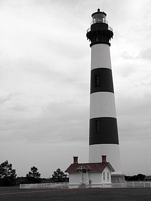
- Bodie Island Lighthouse, south of Nags Head, North Carolina
- Cape Hatteras Lighthouse, in Buxton, North Carolina
- Ocracoke Light, in Ocracoke, North Carolina
- Cape Lookout Lighthouse, in Carteret County, North Carolina
Communities
Here are some towns and communities along the Outer Banks, from north to south:
Currituck Banks
Bodie Island
Roanoke Island
Hatteras Island
Ocracoke Island
Core Banks
Bogue Banks
Parks and Natural Areas
- Back Bay National Wildlife Refuge
- Cape Hatteras National Seashore
- Cape Lookout National Seashore
- Currituck Heritage Park
- Currituck National Wildlife Refuge
- False Cape State Park
- Fort Macon State Park
- Fort Raleigh National Historic Site
- Jockey's Ridge State Park
- Mackay Island National Wildlife Refuge
- Pea Island National Wildlife Refuge
- Wright Brothers National Memorial
Famous People from the Outer Banks
- George Ackles (born 1967), a professional basketball player
- Dennis Anderson (born 1960), a professional Monster Truck driver and creator of Grave Digger
- Marc Basnight (1947–2020), a former member of the North Carolina State Senate
- Emanuel Davis (born 1989), a Canadian Football League defensive back
- Andy Griffith (1926–2012), a famous actor
- Cathy Johnston-Forbes (born 1963), a professional golfer
- Alexis Knapp (born 1989), an actress
- William Ivey Long (born 1947), a costume designer for plays and movies
- Edward Teach (1680–1718), a well-known English pirate who raided the North Atlantic and Caribbean Sea
- Manteo (disappeared after 1587), an important leader in the Croatoan Nation and a helper to England
- Wanchese (disappeared after 1587), an important leader in the Roanoke Nation who was against English settlement
See also
 In Spanish: Bancos Externos para niños
 | James Van Der Zee |
 | Alma Thomas |
 | Ellis Wilson |
 | Margaret Taylor-Burroughs |


