Kitty Hawk, North Carolina facts for kids
Quick facts for kids
Kitty Hawk, North Carolina
|
|||
|---|---|---|---|
|
|||
| Motto(s):
"First in Flight"
|
|||

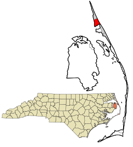
Location in Dare County and the state of North Carolina.
|
|||
| Country | United States | ||
| State | North Carolina | ||
| County | Dare | ||
| Incorporated | 1981 | ||
| Named for | Chickehauk | ||
| Area | |||
| • Total | 8.29 sq mi (21.46 km2) | ||
| • Land | 8.12 sq mi (21.03 km2) | ||
| • Water | 0.17 sq mi (0.43 km2) | ||
| Elevation | 7 ft (2 m) | ||
| Population
(2020)
|
|||
| • Total | 3,689 | ||
| • Density | 454.37/sq mi (175.44/km2) | ||
| Time zone | UTC-5 (Eastern (EST)) | ||
| • Summer (DST) | UTC-4 (EDT) | ||
| ZIP code |
27949
|
||
| Area code(s) | 252 | ||
| FIPS code | 37-36060 | ||
| GNIS feature ID | 1021059 | ||
| Historical population | |||
|---|---|---|---|
| Census | Pop. | %± | |
| 1990 | 1,937 | — | |
| 2000 | 2,991 | 54.4% | |
| 2010 | 3,272 | 9.4% | |
| 2020 | 3,708 | 13.3% | |
| 2021 (est.) | 3,761 | 14.9% | |
| sources: | |||
Kitty Hawk is a town in Dare County, North Carolina, United States. It is located on Bodie Island, which is part of North Carolina's Outer Banks. In 2020, about 3,708 people lived there. The town was first settled in the early 1700s and was known as Chickahawk back then.
Contents
History of Kitty Hawk
How Kitty Hawk Got Its Name
The name Kitty Hawk comes from an old Algonquin Native American word, "Chickahawk." This word means "a place to hunt geese."
The Wright Brothers and First Flight
Kitty Hawk became famous worldwide because of the Wright brothers. On December 17, 1903, they made the first successful powered airplane flights. These flights happened at Kill Devil Hills, which is about 4 miles (6.4 km) south of Kitty Hawk.
After their four flights in the Wright Flyer, the brothers walked back to Kitty Hawk. From the Weather Bureau office there, they sent a telegram to their father to share the exciting news. Kitty Hawk is often given credit for the flights because it was the closest town at that time. The town of Kill Devil Hills didn't exist until 50 years later.
The Wright brothers chose this area because it had strong winds and soft sandy surfaces. These conditions were perfect for their glider experiments, which they worked on for three years before their powered flights.
Connecting to the Mainland
In 1930, the Old Currituck Sound Bridge was finished. This bridge connected the Outer Banks to the mainland across Albemarle Sound. This led to a paved road being built, which finally connected the Outer Banks to the rest of the world by road.
Famous Namesakes
Several important things have been named after Kitty Hawk. These include:
- The aircraft carrier USS Kitty Hawk (CV-63)
- A B-2 Spirit stealth bomber (AV-19)
- The P-40D Kittyhawk fighter aircraft
- The aircraft transport ship USS Kitty Hawk (AKV-1)
- The Apollo 14 command module
Kitty Hawk officially became an incorporated town in 1981. The Kitty Hawk Life-Saving Station was added to the National Register of Historic Places in 1984. This means it's a special place with historical importance.
Geography of Kitty Hawk
Kitty Hawk is located at about 36.1 degrees North latitude and 75.7 degrees West longitude. It is about 7 feet (2 meters) above sea level.
The town covers a total area of about 8.23 square miles (21.3 km2). Most of this area, about 8.18 square miles (21.2 km2), is land. A small part, about 0.0476 square miles (0.123 km2), is water.
Kitty Hawk is served by two main roads: U.S. Route 158 and Highway 12. These roads run side-by-side through the town. US 158 goes west, while Highway 12 runs along the barrier islands, extending north and south.
People of Kitty Hawk
Population in 2020
In 2020, the 2020 United States census counted 3,689 people living in Kitty Hawk. There were 1,532 households and 1,073 families in the town.
| Race | Number | Percentage |
|---|---|---|
| White (non-Hispanic) | 3,324 | 90.11% |
| Black or African American (non-Hispanic) | 18 | 0.49% |
| Native American | 4 | 0.11% |
| Asian | 25 | 0.68% |
| Pacific Islander | 3 | 0.08% |
| Other/Mixed | 134 | 3.63% |
| Hispanic or Latino | 181 | 4.91% |
Sister City
Kitty Hawk has a "sister city" in France. This means they have a special friendship and cultural exchange.
- Coulaines in Pays de la Loire, France (this partnership started in 2005). Coulaines is about 1.7 miles (2.7 km) north of Le Mans.
Climate in Kitty Hawk
Kitty Hawk has a humid subtropical climate. This means it has hot and humid summers, cool winters, and rain throughout the year.
- In summer, a cool sea breeze often blows in the afternoon. However, it can get very hot and humid, with the heat index (how hot it feels) reaching 100°F (38°C) or more.
- Kitty Hawk is in an area where hurricanes can hit, especially from June to November. The peak time for hurricanes is usually in late August and September.
- In winter, it can get cold and windy, with the wind chill (how cold it feels) dropping below 10°F (-12°C).
- The average amount of snow from December to March is less than 2 inches (5 cm).
- The busiest time for "nor'easters" (strong winter storms) is in February.
| Climate data for Kitty Hawk, NC (1981-2010 Averages) | |||||||||||||
|---|---|---|---|---|---|---|---|---|---|---|---|---|---|
| Month | Jan | Feb | Mar | Apr | May | Jun | Jul | Aug | Sep | Oct | Nov | Dec | Year |
| Mean daily maximum °F (°C) | 50.2 (10.1) |
51.9 (11.1) |
57.3 (14.1) |
65.5 (18.6) |
73.0 (22.8) |
80.4 (26.9) |
84.3 (29.1) |
83.0 (28.3) |
78.3 (25.7) |
70.3 (21.3) |
62.3 (16.8) |
54.0 (12.2) |
67.6 (19.8) |
| Daily mean °F (°C) | 43.8 (6.6) |
45.4 (7.4) |
50.3 (10.2) |
58.5 (14.7) |
66.5 (19.2) |
74.9 (23.8) |
79.2 (26.2) |
78.4 (25.8) |
73.8 (23.2) |
64.9 (18.3) |
56.3 (13.5) |
47.6 (8.7) |
61.7 (16.5) |
| Mean daily minimum °F (°C) | 37.4 (3.0) |
38.8 (3.8) |
43.4 (6.3) |
51.5 (10.8) |
60.1 (15.6) |
69.4 (20.8) |
74.1 (23.4) |
73.8 (23.2) |
69.2 (20.7) |
59.5 (15.3) |
50.3 (10.2) |
41.2 (5.1) |
55.8 (13.2) |
| Average precipitation inches (mm) | 4.23 (107) |
3.50 (89) |
3.86 (98) |
3.41 (87) |
3.73 (95) |
4.29 (109) |
4.97 (126) |
5.94 (151) |
5.26 (134) |
3.79 (96) |
3.68 (93) |
3.71 (94) |
50.37 (1,279) |
| Average relative humidity (%) | 69.9 | 69.5 | 67.4 | 67.6 | 70.2 | 73.9 | 75.3 | 74.7 | 73.5 | 71.1 | 72.0 | 71.7 | 71.4 |
| Average dew point °F (°C) | 34.6 (1.4) |
36.0 (2.2) |
39.9 (4.4) |
47.8 (8.8) |
56.5 (13.6) |
66.0 (18.9) |
70.7 (21.5) |
69.7 (20.9) |
64.8 (18.2) |
55.3 (12.9) |
47.4 (8.6) |
38.9 (3.8) |
52.4 (11.3) |
| Source: PRISM | |||||||||||||
| Climate data for Duck, NC Ocean Water Temperature (8 N Kitty Hawk) | |||||||||||||
|---|---|---|---|---|---|---|---|---|---|---|---|---|---|
| Month | Jan | Feb | Mar | Apr | May | Jun | Jul | Aug | Sep | Oct | Nov | Dec | Year |
| Daily mean °F (°C) | 45 (7) |
44 (7) |
46 (8) |
59 (15) |
67 (19) |
74 (23) |
71 (22) |
74 (23) |
75 (24) |
69 (21) |
59 (15) |
52 (11) |
61 (16) |
| Source: NOAA | |||||||||||||
Nature and Environment
Plant Life in Kitty Hawk
Kitty Hawk's natural plant life would mostly be Live oak trees and Sea Oats (a type of grass called Uniola paniculata). This kind of environment is called a Coastal Prairie.
Education in Kitty Hawk
Dare County Schools runs the public schools in the area. Kitty Hawk Elementary School is located right in the town.
Older students go to First Flight Middle School and then to First Flight High School. Before 2004, high school students from Kitty Hawk went to Manteo High School.
See also
 In Spanish: Kitty Hawk (Carolina del Norte) para niños
 | George Robert Carruthers |
 | Patricia Bath |
 | Jan Ernst Matzeliger |
 | Alexander Miles |


