
Dare County, North Carolina facts for kids
Quick facts for kids
Dare County
|
|||
|---|---|---|---|

Dare County Administration Building
|
|||
|
|||
| Nickname(s):
Land of Beginnings
|
|||
| Motto(s):
"Caring for our Community: A Nurturing Place Where We All Can Live and Grow."
|
|||

Location within the U.S. state of North Carolina
|
|||
 North Carolina's location within the U.S. |
|||
| Country | |||
| State | |||
| Founded | 1870 | ||
| Named for | Virginia Dare | ||
| Seat | Manteo | ||
| Largest municipality | Kill Devil Hills | ||
| Area | |||
| • Total | 1,541.74 sq mi (3,993.1 km2) | ||
| • Land | 383.23 sq mi (992.6 km2) | ||
| • Water | 1,158.51 sq mi (3,000.5 km2) 75.14% | ||
| Population
(2020)
|
|||
| • Total | 36,915 | ||
| • Estimate
(2023)
|
38,110 | ||
| • Density | 96.33/sq mi (37.19/km2) | ||
| Time zone | UTC−5 (Eastern) | ||
| • Summer (DST) | UTC−4 (EDT) | ||
| Congressional district | 3rd | ||


Dare County is a county located in the state of North Carolina in the United States. It's the easternmost county in the state. In 2020, about 36,915 people lived here.
The main town, or county seat, is Manteo. Dare County is part of a larger area that includes Kill Devil Hills. This area is also close to the Virginia Beach-Chesapeake, VA-NC Combined Statistical Area.
Dare County is the largest county in North Carolina by total area. This is because it includes a big part of Pamlico Sound, which is a large body of water. If you only count the land area, it's much smaller, ranking 68th out of 100 counties.
Contents
History of Dare County
Dare County got its name from Virginia Dare. She was the very first English child born in the Americas. She was born right within the area that is now Dare County.
The county was created in 1870. It was formed from parts of other counties like Tyrrell, Currituck, and Hyde. Dare County includes a big part of the Outer Banks of North Carolina. It also has Roanoke Island and a piece of land connected to the mainland.
Most of Dare County is made up of popular vacation spots along the Outer Banks. Not many people live there all year round. But in the summer, lots of tourists come to visit, making the population much larger! Long ago, a town called Buffalo City was the biggest community in the county, but it's now abandoned.
Geography and Nature

Dare County covers a total area of about 1,542 square miles (3,994 square kilometers). Most of this area, about 75%, is water. Only about 383 square miles (992 square kilometers) is land. This makes it the largest county in North Carolina by its total size.
The county includes the middle part of the Outer Banks. It also contains Roanoke Island, which is famous for its history.
Special Protected Areas
Dare County is home to several important natural and historical sites. These places are protected to keep them safe for nature and for people to visit.
National Parks and Refuges
- Alligator River National Wildlife Refuge (part of it is in Dare County)
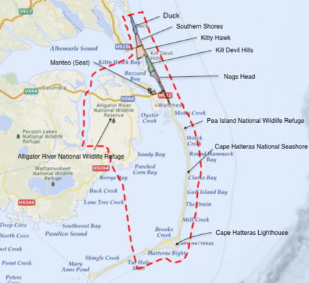
- Cape Hatteras National Seashore (a beautiful coastal area)
- Fort Raleigh National Historic Site (a historical site on Roanoke Island)
- Monitor National Marine Sanctuary (an underwater protected area)
- Pea Island National Wildlife Refuge (a haven for birds and wildlife)
- Wright Brothers National Memorial (where the first flight happened)
State and Local Natural Spots
- Bodie Island Lighthouse (a historic lighthouse)
- Buxton Woods Coastal Reserve Dedicated Nature Preserve (a protected forest)
- Cape Hatteras Lighthouse (the tallest brick lighthouse in North America)
- Graveyard of the Atlantic Museum (learn about shipwrecks!)
- Jennette's Pier (a long fishing pier)
- Jockey's Ridge State Park (the tallest sand dune on the Atlantic coast)
- North Carolina Aquarium on Roanoke Island (see amazing sea creatures)
- Roanoke Island Festival Park (a fun place to learn about history)
- Run Hill State Natural Area (another protected natural area)
Major Waterways
Dare County has many important water bodies that shape its geography:
- Albemarle Sound
- Atlantic Ocean (the big ocean to the east!)
- Croatan Sound
- Currituck Sound
- Pamlico Sound (a very large sound)
- Roanoke Sound
Neighboring Counties
Dare County shares borders with these other counties:
- Currituck County to the north
- Hyde County to the southwest
- Tyrrell County to the west
Main Roads
Several important highways run through Dare County, helping people travel around:
- US 64
- US 158
- US 264
- NC 12 (a scenic road along the Outer Banks)
Important Places and Buildings
- Dare County Regional Airport (a local airport)
- First Flight Airport (located at the Wright Brothers National Memorial)
- Hatteras–Ocracoke Ferry (a ferry that takes you to Ocracoke Island)
Population Facts
| Historical population | |||
|---|---|---|---|
| Census | Pop. | %± | |
| 1870 | 2,778 | — | |
| 1880 | 3,243 | 16.7% | |
| 1890 | 3,768 | 16.2% | |
| 1900 | 4,757 | 26.2% | |
| 1910 | 4,841 | 1.8% | |
| 1920 | 5,115 | 5.7% | |
| 1930 | 5,202 | 1.7% | |
| 1940 | 6,401 | 23.0% | |
| 1950 | 5,405 | −15.6% | |
| 1960 | 5,935 | 9.8% | |
| 1970 | 6,995 | 17.9% | |
| 1980 | 13,377 | 91.2% | |
| 1990 | 22,746 | 70.0% | |
| 2000 | 29,959 | 31.7% | |
| 2010 | 33,920 | 13.2% | |
| 2020 | 36,915 | 8.8% | |
| 2023 (est.) | 38,110 | 12.4% | |
| U.S. Decennial Census 1790–1960 1900–1990 1990–2000 2010 2020 |
|||
In 2020, the census counted 36,915 people living in Dare County. There were about 15,529 households and 10,281 families.
Most people in Dare County are White. Here's a quick look at the different groups:
| Group | Number | Percentage |
|---|---|---|
| White (not Hispanic) | 31,921 | 86.47% |
| Black or African American (not Hispanic) | 678 | 1.84% |
| Native American | 99 | 0.27% |
| Asian | 260 | 0.7% |
| Pacific Islander | 10 | 0.03% |
| Other/Mixed | 1,393 | 3.77% |
| Hispanic or Latino | 2,554 | 6.92% |
Schools and Learning
Public schools in Dare County are managed by Dare County Schools. There are three main high schools for older students:
- Cape Hatteras Secondary School
- First Flight High School
- Manteo High School
For students who want to continue their education after high school, there's College of The Albemarle. It has a campus in Manteo. The Dare County Library also has branches in Manteo, Kill Devil Hills, and Hatteras, where you can find books and resources.
Lighthouses of Dare County
Dare County is famous for its beautiful lighthouses that guide ships.
- The Cape Hatteras Lighthouse is very tall and well-known.
- The Bodie Island Lighthouse is another popular one.
- There's also a light on top of the Wright Brothers National Memorial.
- The Roanoke Marshes Lighthouse is a newer lighthouse built in Manteo. It looks like an old lighthouse from 1877 and is part of the N.C. Maritime Museum.
Communities in Dare County
Towns You Can Visit
- Duck
- Kill Devil Hills (This is the largest town!)
- Kitty Hawk
- Manteo (This is the county seat, where the county government is)
- Nags Head
- Southern Shores
Other Communities
There are also smaller communities in Dare County:
- Avon
- Buxton
- Frisco
- Hatteras
- Manns Harbor
- Rodanthe
- Salvo
- Wanchese
- Waves
- Colington
- East Lake
- Stumpy Point
Ghost Towns
Dare County even has some "ghost towns" – places that used to be busy but are now abandoned:
- Buffalo City (It was founded in the 1870s and abandoned by the 1950s. It once had 3,000 people!)
- Burptoe Village (It was founded in 1892 and abandoned by 1950.)
- Port Frenz (It started as Fort Frent in 1862 and was abandoned by 1932.)
See also
 In Spanish: Condado de Dare para niños
