
Currituck County, North Carolina facts for kids
Quick facts for kids
Currituck County
|
|||
|---|---|---|---|

Currituck County Courthouse
|
|||
|
|||

Location within the U.S. state of North Carolina
|
|||
 North Carolina's location within the U.S. |
|||
| Country | |||
| State | |||
| Founded | 1668 | ||
| Named for | Algonquin term meaning "The Land of the Wild Geese" | ||
| Seat | Currituck | ||
| Largest community | Moyock | ||
| Area | |||
| • Total | 526.43 sq mi (1,363.4 km2) | ||
| • Land | 261.91 sq mi (678.3 km2) | ||
| • Water | 264.52 sq mi (685.1 km2) 50.25% | ||
| Population
(2020)
|
|||
| • Total | 28,100 | ||
| • Estimate
(2023)
|
31,593 | ||
| • Density | 107.29/sq mi (41.42/km2) | ||
| Time zone | UTC−5 (Eastern) | ||
| • Summer (DST) | UTC−4 (EDT) | ||
| Congressional district | 3rd | ||


Currituck County is a county in the northeastern part of North Carolina. It is the very first county you reach when coming from the north.
In 2020, about 28,100 people lived here. The main town, or "county seat," is Currituck. This is where the county government offices are located.
The county was first set up in 1668. It was part of a larger area called Albemarle County. Later, in 1739, it became its own county. The name "Currituck" is thought to come from an old Native American word. It means "The Land of the Wild Geese."
Currituck County is close to Virginia Beach and Chesapeake in Virginia. It touches the Atlantic Ocean and Currituck Sound. It also shares borders with Camden County, Dare County, and the state of Virginia.
Contents
History of Currituck County

Currituck County was formed in 1668. It was created from a larger area called Albemarle County.
The biggest community in Currituck County today is Moyock. The county seat, where the main government offices are, is called Currituck.
Geography and Nature
Currituck County covers about 526 square miles. A little more than half of this area is land. The rest is water, like sounds and the ocean.
The northern part of North Carolina's famous Outer Banks is in Currituck County. These are long, thin islands that separate the mainland from the Atlantic Ocean. The Currituck Sound is the body of water that lies between the mainland and the Outer Banks.
Protected Natural Areas
Currituck County has special places where nature is protected. These areas help keep animals and plants safe.
- Currituck National Wildlife Refuge
- Mackay Island National Wildlife Refuge (part of it is here)
State and Local Protected Sites
- Currituck Banks Estuarine Reserve Dedicated Nature Preserve
- Currituck Banks Game Land
- Currituck Banks Reserve
- Currituck Beach Lighthouse
- Currituck Outer Banks Preserve Dedicated Nature Preserve
- Mackay Island National Wildlife Refuge (part of it is here)
- Monkey Island
- North River Game Land (part of it is here)
- Northwest River Marsh Game Land
Major Waterways
Many important bodies of water are found in or near Currituck County.
- Albemarle Sound
- Atlantic Ocean
- Currituck Sound
- Intracoastal Waterway (a channel for boats)
- North River
- Northwest River
Neighboring Counties and Cities
Currituck County shares its borders with several other places.
- City of Chesapeake, Virginia – to the north
- City of Virginia Beach, Virginia – to the north
- Dare County – to the south
- Tyrrell County – to the southwest
- Camden County – to the southwest
Main Roads and Transportation
Several important roads run through Currituck County.
 US 158
 NC 12
NC 12 NC 34
NC 34 NC 136
 NC 168
 NC 615
Important Places for Travel
- Currituck County Regional Airport (a local airport)
- Knotts Island–Currituck Ferry (a boat service)
Population Information
| Historical population | |||
|---|---|---|---|
| Census | Pop. | %± | |
| 1790 | 5,220 | — | |
| 1800 | 6,928 | 32.7% | |
| 1810 | 6,985 | 0.8% | |
| 1820 | 8,098 | 15.9% | |
| 1830 | 7,655 | −5.5% | |
| 1840 | 6,703 | −12.4% | |
| 1850 | 7,236 | 8.0% | |
| 1860 | 7,415 | 2.5% | |
| 1870 | 5,131 | −30.8% | |
| 1880 | 6,476 | 26.2% | |
| 1890 | 6,747 | 4.2% | |
| 1900 | 6,529 | −3.2% | |
| 1910 | 7,693 | 17.8% | |
| 1920 | 7,268 | −5.5% | |
| 1930 | 6,710 | −7.7% | |
| 1940 | 6,709 | 0.0% | |
| 1950 | 6,201 | −7.6% | |
| 1960 | 6,601 | 6.5% | |
| 1970 | 6,976 | 5.7% | |
| 1980 | 11,089 | 59.0% | |
| 1990 | 13,736 | 23.9% | |
| 2000 | 18,190 | 32.4% | |
| 2010 | 23,547 | 29.5% | |
| 2020 | 28,100 | 19.3% | |
| 2023 (est.) | 31,593 | 34.2% | |
| U.S. Decennial Census 2010–2020 |
|||
The number of people living in Currituck County has grown a lot over the years. In 1790, there were about 5,220 people. By 2020, the population had grown to 28,100.
Who Lives in Currituck County?
Based on the 2020 census, here's a look at the different groups of people living in Currituck County:
| Group | Number | Percentage |
|---|---|---|
| White (not Hispanic) | 23,505 | 83.65% |
| Black or African American (not Hispanic) | 1,377 | 4.9% |
| Native American | 98 | 0.35% |
| Asian | 265 | 0.94% |
| Pacific Islander | 22 | 0.08% |
| Other/Mixed | 1,615 | 5.75% |
| Hispanic or Latino | 1,218 | 4.33% |
In 2020, there were 28,100 people living in the county. These people lived in about 10,522 homes. About 7,467 of these homes were families.
Schools in Currituck County
The schools in Currituck County are managed by a group of five people. They are elected to the Board of Education.
Here are the schools located in the county:
- Central Elementary School
- Currituck County High School
- Currituck County Middle School
- J.P. Knapp Early College High School
- Jarvisburg Elementary School
- Knotts Island Elementary School
- Moyock Elementary School
- Moyock Middle School
- Shawboro Elementary School
- W.T. Griggs Elementary School
- Jarvisburg Christian Academy
Communities in Currituck County

Currituck County has several towns and communities.
Main Communities (Census-designated places)
These are areas that the census bureau counts as specific places.
Townships
Townships are smaller areas within the county.
- Crawford
- Fruitville
- Moyock
- Poplar Branch
Other Smaller Communities
These are other towns and areas that are not officially incorporated as cities or towns.
- Aydlett
- Barco
- Carova Beach
- Corolla
- Currituck (This is the county seat.)
- Gibbs Woods
- Grandy
- Gregory
- Harbinger
- Knotts Island
- Jarvisburg
- Mamie
- Maple
- North Swan Beach
- Point Harbor
- Poplar Beach
- Poplar Branch
- Powells Point
- Swan Beach
- Shawboro
- Sligo
- Spot
- Waterlily
Famous People from Currituck County
Many interesting people have connections to Currituck County.
- Dennis Anderson – He created and drove the famous Grave Digger monster truck.
- Linda Carter Brinson – An American journalist.
- Macon Brock – He founded the store Dollar Tree and had a beach house in Corolla.
- Richard Thurmond Chatham – He once owned a hunt club called Dews Island in Jarvisburg.
- Emerson Etheridge – A congressman who supported the Union during the Civil War.
- John Gibbs – He led a rebellion in colonial times. Gibbs Woods, NC, is named after him.
- Thomas Jarvis – He was a Colonial Governor of North Carolina.
- Thomas Jordan Jarvis – He was also a Governor of North Carolina.
- Joseph P. Knapp – A publisher and generous person. J.P. Knapp Early College High School is named after him.
- Antonin Scalia – A Supreme Court Justice who had a beach house in Corolla.
- Henry Marchmore Shaw – A congressman and officer in the Confederate army.
Images for kids
-
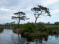
Pine trees are common in Mackay Island National Wildlife Refuge.

See also
 In Spanish: Condado de Currituck para niños
