Camden County, North Carolina facts for kids
Quick facts for kids
Camden County
|
|||||
|---|---|---|---|---|---|
|
Consolidated city-county
|
|||||

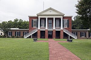
Camden County Courthouse
|
|||||
|
|||||
| Motto(s):
"Boundless Opportunities."
|
|||||

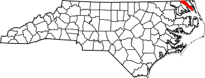
Location within the U.S. state of North Carolina
|
|||||
 North Carolina's location within the U.S. |
|||||
| Country | |||||
| State | |||||
| Founded | 1777 (Consolidated July 1, 2006) |
||||
| Named for | Charles Pratt, 1st Earl Camden | ||||
| Seat | Camden | ||||
| Largest community | Camden | ||||
| Area | |||||
| • Total | 310.25 sq mi (803.5 km2) | ||||
| • Land | 240.33 sq mi (622.5 km2) | ||||
| • Water | 69.92 sq mi (181.1 km2) 22.54% | ||||
| Population
(2020)
|
|||||
| • Total | 10,355 | ||||
| • Estimate
(2023)
|
11,137 | ||||
| • Density | 43.00/sq mi (16.60/km2) | ||||
| Time zone | UTC−5 (Eastern) | ||||
| • Summer (DST) | UTC−4 (EDT) | ||||
| Congressional district | 3rd | ||||
Camden County is a special kind of county in the U.S. state of North Carolina. It's called a consolidated city-county because the county government and the main town government work together as one.
In 2020, about 10,355 people lived here. This makes it one of the least populated counties in North Carolina. The main town and county seat is Camden. Camden County is also part of a larger area that includes Virginia Beach and Chesapeake in Virginia.
Contents
History of Camden County
Camden County was created in 1777. It was formed from the northeastern part of Pasquotank County. The county was named after Charles Pratt. He was a British lord who spoke out against the Stamp Act. This act was a tax that angered the American colonists before the Revolutionary War.
The county is home to the southern end of the Dismal Swamp Canal. This canal is an important waterway. During the American Civil War, a small battle happened here. It was called the Battle of South Mills on April 19, 1862. The Southern forces won this minor battle.
Shiloh Baptist Church is also in Camden County. It was started around 1727 by Paul Palmer. This church is known as the oldest Baptist church in North Carolina. It is located in the Shiloh area.
Even though Camden County didn't have many official towns, it became the first consolidated city-county in North Carolina. This happened on July 1, 2006. This means the county and its main community share one government.
Geography of Camden County
| Weather chart for Camden County, NC | |||||||||||||||||||||||||||||||||||||||||||||||
|---|---|---|---|---|---|---|---|---|---|---|---|---|---|---|---|---|---|---|---|---|---|---|---|---|---|---|---|---|---|---|---|---|---|---|---|---|---|---|---|---|---|---|---|---|---|---|---|
| J | F | M | A | M | J | J | A | S | O | N | D | ||||||||||||||||||||||||||||||||||||
|
3.7
51
31
|
3.4
54
33
|
3.9
61
39
|
3.5
71
47
|
3.9
78
56
|
4.4
86
66
|
5.5
89
70
|
5.5
87
68
|
5
82
63
|
3.5
73
51
|
3.3
64
43
|
3.6
54
34
|
||||||||||||||||||||||||||||||||||||
| temperatures in °F precipitation totals in inches |
|||||||||||||||||||||||||||||||||||||||||||||||
|
Metric conversion
|
|||||||||||||||||||||||||||||||||||||||||||||||
Camden County covers a total area of about 310 square miles (803 square kilometers). Most of this area, about 240 square miles (622 square kilometers), is land. The rest, about 70 square miles (181 square kilometers), is water.
Protected Areas
Camden County has several important natural areas.
National Protected Area
- Great Dismal Swamp National Wildlife Refuge (part of it is in Camden County)
State and Local Protected Areas
- Dismal Swamp State Park
- North River Game Land (part of it is here)
Major Water Bodies
Many rivers and sounds are found in Camden County.
- Albemarle Sound
- Intracoastal Waterway
- North River
- Pasquotank River
Neighboring Counties
Camden County shares borders with several other counties and cities.
- City of Suffolk, Virginia – to the north
- City of Chesapeake, Virginia – to the north
- Currituck County – to the east
- Tyrrell County – to the south
- Pasquotank County – to the southwest
- Gates County – to the northwest
Main Roads
Several important highways run through Camden County.

 Future I-87
 US 17
US 17
 US 17 Bus.
 US 158
 NC 34
NC 34 NC 343
Population Information
| Historical population | |||
|---|---|---|---|
| Census | Pop. | %± | |
| 1790 | 4,022 | — | |
| 1800 | 4,191 | 4.2% | |
| 1810 | 5,347 | 27.6% | |
| 1820 | 6,347 | 18.7% | |
| 1830 | 6,733 | 6.1% | |
| 1840 | 5,663 | −15.9% | |
| 1850 | 6,049 | 6.8% | |
| 1860 | 5,343 | −11.7% | |
| 1870 | 5,361 | 0.3% | |
| 1880 | 6,274 | 17.0% | |
| 1890 | 5,667 | −9.7% | |
| 1900 | 5,474 | −3.4% | |
| 1910 | 5,640 | 3.0% | |
| 1920 | 5,382 | −4.6% | |
| 1930 | 5,461 | 1.5% | |
| 1940 | 5,440 | −0.4% | |
| 1950 | 5,223 | −4.0% | |
| 1960 | 5,598 | 7.2% | |
| 1970 | 5,453 | −2.6% | |
| 1980 | 5,829 | 6.9% | |
| 1990 | 5,904 | 1.3% | |
| 2000 | 6,885 | 16.6% | |
| 2010 | 9,980 | 45.0% | |
| 2020 | 10,355 | 3.8% | |
| 2023 (est.) | 11,137 | 11.6% | |
| U.S. Decennial Census 1790–1960 1900–1990 1990–2000 2010 2020 |
|||
2020 Census
In 2020, the census counted 10,355 people living in Camden County. There were 3,933 households and 3,154 families. Most people identified as White (about 79%). About 10% identified as Black or African American. Other groups made up smaller parts of the population.
2010 Census
The 2010 census showed 9,980 people in the county. The population was mostly White (82.1%) and Black or African American (13.2%). About 2.2% of the people were of Hispanic or Latino background.
The average age of people in the county was 39 years old. About 24.5% of the population was under 18 years old.
Education in Camden County
Camden County has five schools for students. These schools help kids learn and grow.
- Grandy Primary School
- Camden Intermediate School
- Camden Middle School
- Camden County High School
- Camden Early College
There was also an old community school in Shiloh. The sign for Shiloh School can still be seen on the building.
Communities in Camden County
Camden County has several communities.
City
- Elizabeth City (most of this city is in Pasquotank County)
Main Communities (Census-designated places)
- Camden (This is the county seat and the largest community.)
- South Mills
Other Communities (Unincorporated)
- Black Swamp
- Old Trap
- Shiloh
Townships
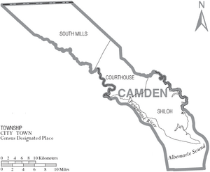
The county is divided into smaller areas called townships.
- Courthouse
- Shiloh
- South Mills
See also
 In Spanish: Condado de Camden (Carolina del Norte) para niños
 | Emma Amos |
 | Edward Mitchell Bannister |
 | Larry D. Alexander |
 | Ernie Barnes |


