Pasquotank County, North Carolina facts for kids
Quick facts for kids
Pasquotank County
|
||
|---|---|---|

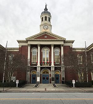
Pasquotank County Courthouse
|
||
|
||

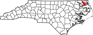
Location within the U.S. state of North Carolina
|
||
 North Carolina's location within the U.S. |
||
| Country | ||
| State | ||
| Founded | 1668 | |
| Named for | Indian word meaning "where the current of the stream divides or forks" | |
| Seat | Elizabeth City | |
| Largest community | Elizabeth City | |
| Area | ||
| • Total | 289.33 sq mi (749.4 km2) | |
| • Land | 226.88 sq mi (587.6 km2) | |
| • Water | 62.45 sq mi (161.7 km2) 21.58% | |
| Population
(2020)
|
||
| • Total | 40,568 | |
| • Estimate
(2023)
|
41,444 | |
| • Density | 178.81/sq mi (69.04/km2) | |
| Time zone | UTC−5 (Eastern) | |
| • Summer (DST) | UTC−4 (EDT) | |
| Congressional district | 1st | |
Pasquotank County is a county in North Carolina, a state in the United States. The name Pasquotank comes from an old Indian word. It means "where the current of the stream divides or forks."
In 2020, about 40,568 people lived here. The main town and county seat is Elizabeth City. Pasquotank County is part of a larger area that includes Elizabeth City and is also connected to the Virginia Beach area.
Contents
History of Pasquotank County
Pasquotank County started as a smaller area called Pasquotank Precinct in 1668. It officially became a county in 1739. Elizabeth City is the biggest town and the county seat.
Geography and Nature
Pasquotank County covers about 289 square miles. Most of this area, about 227 square miles, is land. The rest, about 62 square miles, is water. It is one of the smallest counties in North Carolina by land size.
The land in Pasquotank County is mostly flat and close to sea level. This is typical for the Coastal Plain of North Carolina. Two important rivers flow along the county: the Pasquotank River and the Little River.
Protected Natural Areas
- Great Dismal Swamp National Wildlife Refuge (part of this refuge is in the county)
Local Attractions and Sites
- Museum of the Albemarle
Major Waterways
- Albemarle Sound
- Big Flatty Creek
- Intracoastal Waterway
- Little River
- Newbegun Creek
- Pasquotank River
Neighboring Counties
Pasquotank County shares borders with these other counties:
- Gates County – to the northwest
- Camden County – to the east
- Tyrrell County – to the south
- Perquimans County – to the southwest
Main Roads and Transportation
Several important roads pass through Pasquotank County:

 Future I-87
 US 17
US 17 US 158
 NC 344
The county also has the Elizabeth City Regional Airport.
Population and People
Pasquotank County has grown a lot over the years. In 1790, about 5,477 people lived there. By 2020, the population had grown to 40,568.
Population in 2020
In 2020, there were 40,568 people living in Pasquotank County. These people lived in 14,697 households, with 9,829 of those being families.
The population includes people from many different backgrounds:
| Group | Number | Percentage |
|---|---|---|
| White (not Hispanic) | 21,577 | 53.19% |
| Black or African American (not Hispanic) | 14,316 | 35.29% |
| Native American | 150 | 0.37% |
| Asian | 458 | 1.13% |
| Pacific Islander | 28 | 0.07% |
| Other or Mixed Race | 1,802 | 4.44% |
| Hispanic or Latino | 2,237 | 5.51% |
Education in Pasquotank County
Pasquotank County has several schools and colleges. These include:
- College of The Albemarle
- Elizabeth City State University
- Mid-Atlantic Christian University
- Pasquotank County High School
Towns and Communities
City
- Elizabeth City (This is the county seat and the largest community.)
Other Communities
These are smaller areas that are not officially cities or towns:
Township Areas
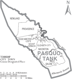
Counties are often divided into smaller areas called townships. Pasquotank County has these townships:
- Elizabeth City
- Mount Hermon
- Newland
- Nixonton
- Providence
- Salem
Images for kids
See also
 In Spanish: Condado de Pasquotank para niños
 | Delilah Pierce |
 | Gordon Parks |
 | Augusta Savage |
 | Charles Ethan Porter |


