
Gates County, North Carolina facts for kids
Quick facts for kids
Gates County
|
|||
|---|---|---|---|

Old Gates County Courthouse in Gatesville
|
|||
|
|||

Location within the U.S. state of North Carolina
|
|||
 North Carolina's location within the U.S. |
|||
| Country | |||
| State | |||
| Founded | 1779 | ||
| Named for | General Horatio Gates | ||
| Seat | Gatesville | ||
| Largest community | Gatesville | ||
| Area | |||
| • Total | 345.74 sq mi (895.5 km2) | ||
| • Land | 340.61 sq mi (882.2 km2) | ||
| • Water | 5.13 sq mi (13.3 km2) 1.48% | ||
| Population
(2020)
|
|||
| • Total | 10,478 | ||
| • Estimate
(2023)
|
10,343 | ||
| • Density | 31.56/sq mi (12.19/km2) | ||
| Time zone | UTC−5 (Eastern) | ||
| • Summer (DST) | UTC−4 (EDT) | ||
| Congressional district | 1st | ||


Gates County is a county in the northeastern part of North Carolina. It shares a border with Virginia. In 2020, about 10,478 people lived here. This makes it one of the least populated counties in North Carolina. The main town and county seat is Gatesville. Gates County is also part of a larger area called the Virginia Beach-Chesapeake, VA-NC Combined Statistical Area. It's located in the Albemarle Sound area, which is part of the Inner Banks.
Contents
History of Gates County
Early Times and Native Americans
For thousands of years, different groups of Native Americans lived in this area. They built settlements along the Chowan River. When Europeans first arrived, the Chowanoke tribe was the largest in North Carolina. They spoke an Algonquian language.
Sadly, many Chowanoke people died from new diseases brought by Europeans. These diseases were new to them, so they had no natural protection. The remaining Chowanoke were often pushed out by other tribes, like the Tuscarora.
In 1585, explorers from the Ralph Lane Colony explored the Chowan River. In 1622, the John Pory Colony also explored the area from Virginia. Later, in 1629, Sir Robert Heath received permission to settle Carolina. This land included what is now Gates County.
The Chowanoke fought against the European settlers in 1644 but lost. In the 1650s, more settlers from Virginia moved into the Albemarle Sound region. The first English settlement in Gates County was started near Corapeake in 1660.
The Chowanoke fought again from 1675 to 1677. After they lost, the English created the first Native American reservation in the United States in 1677. This was the 11,360-acre Chowanoke Indian Reservation. It was located between Bennett's Creek and Catherine Creek in Gates County.
From 1684 to 1722, Gates County was part of the Chowan precinct. In the 1700s, the Chowanoke tribe lost most of their land. They sold parts of it to help their tribe survive. Some members married people from other tribes, like the Meherrin people, or English and African settlers.
Gates County was officially formed in 1779. It was made from parts of Chowan, Hertford, and Perquimans counties. It was named after General Horatio Gates. He led the American forces to victory at the Battle of Saratoga in 1777.
The 1800s in Gates County
In 1806, the first Baptist church in Gates County, Middle Swamp Baptist Church, was built. In 1811, Savages United Methodist Church was established. Both churches welcomed enslaved people and free Black people as members. Sometimes, enslaved people and free Black people even became preachers.
The Chowanoke Indians lost their last piece of shared land in 1821. Even though most farmers in Gates County owned few enslaved people, the South had a society where people were often divided by race. However, Native Americans kept their culture alive. They welcomed people of other races into their families. Many Chowanoke were seen as "free people of color." Gates County also became home to many free Black people who sought better lives than in other states.
In 1825, the Marquis de Lafayette, a French hero of the American Revolution, visited Gates County. He was welcomed at Pipkin's Inn. The town of Gatesville became an official town in 1830. The old courthouse was built in 1836. Its oldest part is a bell bought in 1781.
In 1859, free people of color started the New Hope Baptist Church.
Port of Hamburg and Canals
People in Gates County wanted better ways to reach major ports. From 1805 to 1822, they dug the White Oak Marsh Canal, also called Hamburg Ditch. This canal was about 3 miles (4.8 km) south of the Virginia border. It was Gates County's water path to the big port of Norfolk. It ran east for 10 miles (16 km) through the Great Dismal Swamp. This canal connected to the Dismal Swamp Canal, which led to Norfolk.
Today, the Cross Canal is no longer a through route. Hurricanes have knocked down trees and blocked it.
Civil War and Aftermath
Before the American Civil War, much of Gates County was covered with old forests. In 1861, A. J. Walton represented Gates County at the North Carolina meeting to decide on leaving the Union. After North Carolina voted to leave, two local military companies were formed: the "Gates Guard" and the "Gates Minutemen." Gates County mostly helped the Confederate States Army by providing food.
Two generals from Gates County served in the war: General William Paul Roberts, who became the youngest general, and Brigadier General Laurence S. Baker.
During the war, a group of troublemakers called the "Buffaloes" caused problems in Gates County. They were made up of people who avoided fighting, soldiers who left the army, and other outlaws. They bothered the older men, women, and children who were trying to keep their farms running.
Fort Dillard was a Confederate post in Gates County. Union soldiers sometimes raided the county. There's a story about the "Ellis Girls." While fishing in the Chowan River, the sisters saw a Union gunboat heading to attack Winton. Union soldiers captured the girls and held them until they had burned down the town.
In 1878, peanuts were first grown in Gates County. Thad Eure, who later became a Secretary of State, was born here in 1899.
The 1900s and Modern Times
On May 9, 1925, the first bridge opened across the Chowan River. It connected Gates and Hertford counties. In 1925, U.S. Route 158 opened, going through the Great Dismal Swamp.
In the 1930s, during the Great Depression, Gates County had no paved roads. Few people owned cars. Most families grew their own food and raised animals. In 1935, the Sunbury Ruritan Club was started. This club helped improve the town. For example, they sponsored a fair, helped get a stop signal, bought school books for kids, and helped pay for school shades.
Beckford Junction was a train switch that allowed trains to go to Suffolk, Elizabeth City, or Edenton. It was closed in 1940. The last passenger train in Gates County stopped service in 1954. That same year, the Gates County Historical Society was formed.
In 1973, A.B. Coleman gave 925 acres (3.7 km2) of land to the state. This land became the basis for Merchants Millpond State Park.
In 1984, a tornado hit Gates County. It killed two people and caused a lot of damage. Hurricane Floyd also hit Gates County in 1999.
The 2000s
In 2007, Gates County was considered as a possible location for a US Navy landing field.
In 2014, Delois Chavis, a descendant of the Chowanoke tribe, worked with others to buy 146 acres (0.59 km2) of their tribe's old reservation land. They want to revive the tribe and plan to build a cultural center there.
Geography of Gates County

Gates County covers about 345.75 square miles (895.5 km2). Most of this is land (340.61 sq mi or 882.2 km2). A small part is water (5.13 sq mi or 13.3 km2).
Protected Natural Areas
Great Dismal Swamp
Gates County is home to a large part of the Great Dismal Swamp. In 1973, a company donated land in the swamp to a conservation group. This land then became the Great Dismal Swamp National Wildlife Refuge. This refuge protects about 107,000 acres (433 km2) of swamp and wetlands around Lake Drummond.
State and Local Parks
- Chowan Swamp Game Land (part)
- Chowan Swamp State Natural Area
- Merchants Millpond State Park
In 1811, the Norfleet family built the first dam at what is now Merchants Millpond. It was used to grind corn. In 1910, Charles Lawrence bought the millpond, and it became known as Merchants Millpond. In 1973, A.B. Coleman donated 925 acres (3.7 km2) of the land to North Carolina. He wanted it to become a state park. Today, Merchants Millpond State Park is about 3,200 acres (13 km2).
Major Waterways
Neighboring Counties
- City of Suffolk, Virginia – north
- Camden County – northeast
- Pasquotank County – east
- Perquimans County – south
- Chowan County – south
- Hertford County – west
- Southampton County, Virginia – northwest
Main Roads
 US 13
US 13 US 158


US 158 Bus. NC 32
NC 32 NC 37
NC 37 NC 137
People of Gates County
| Historical population | |||
|---|---|---|---|
| Census | Pop. | %± | |
| 1790 | 5,386 | — | |
| 1800 | 5,881 | 9.2% | |
| 1810 | 5,965 | 1.4% | |
| 1820 | 6,837 | 14.6% | |
| 1830 | 7,866 | 15.1% | |
| 1840 | 8,161 | 3.8% | |
| 1850 | 8,426 | 3.2% | |
| 1860 | 8,443 | 0.2% | |
| 1870 | 7,724 | −8.5% | |
| 1880 | 8,897 | 15.2% | |
| 1890 | 10,252 | 15.2% | |
| 1900 | 10,413 | 1.6% | |
| 1910 | 10,455 | 0.4% | |
| 1920 | 10,537 | 0.8% | |
| 1930 | 10,551 | 0.1% | |
| 1940 | 10,060 | −4.7% | |
| 1950 | 9,555 | −5.0% | |
| 1960 | 9,254 | −3.2% | |
| 1970 | 8,524 | −7.9% | |
| 1980 | 8,875 | 4.1% | |
| 1990 | 9,305 | 4.8% | |
| 2000 | 10,516 | 13.0% | |
| 2010 | 12,197 | 16.0% | |
| 2020 | 10,478 | −14.1% | |
| 2023 (est.) | 10,343 | −15.2% | |
| U.S. Decennial Census 1790–1960 1900–1990 1990–2000 2010 2020 |
|||
Population in 2020
| Race | Number | Percentage |
|---|---|---|
| White (not Hispanic) | 6,705 | 63.99% |
| Black or African American (not Hispanic) | 3,022 | 28.84% |
| Native American | 64 | 0.61% |
| Asian | 21 | 0.2% |
| Pacific Islander | 10 | 0.1% |
| Other/Mixed | 455 | 4.34% |
| Hispanic or Latino | 201 | 1.92% |
In 2020, there were 10,478 people living in Gates County. These people lived in 4,638 households, with 3,205 being families.
Population in 2010
In 2010, Gates County had 12,197 people. The population density was about 31 people per square mile (12 people per km2).
The people living in the county were:
- 63.7% White
- 33.2% Black or African American
- 0.5% Native American
- 0.1% Asian
- 0.1% Pacific Islander
- 0.6% from other races
- 1.8% from two or more races.
- 1.4% of the population were Hispanic or Latino.
About 26.7% of the population was under 18 years old. The average age was 38 years.
Economy
Most of Gates County's money comes from taxes on property. A smaller amount comes from businesses.
Main Industries
The main jobs and businesses in Gates County are related to farming and forest products. Tourism and outdoor activities are also becoming more important.
Education
Gates County Schools has five schools. These schools teach students from pre-kindergarten all the way to twelfth grade. There is one high school (Gates County Senior High School), one middle school, and three elementary schools.
Gates County is proud of its high school sports teams. The Gates County High School football team won a state championship in 1971. In 2010, the football team, called the Red Barons, won their conference. In 2023, the Red Barons soccer team also went undefeated in their conference. Many athletes from Gates County have gone on to play professionally, like Thomas Smith (Buffalo Bills) and Walter Smith I (Toronto Argonauts).
Rosenwald Schools
Rosenwald Schools were special schools built for Black children in the South. They were funded by the Rosenwald Fund, started by Julius Rosenwald in 1917. He was a businessman who led Sears Corporation. The fund helped build schools because the public school system often did not serve Black children well.
For a Rosenwald School to be built, local communities had to raise some money themselves. Black communities worked very hard to raise money. They sometimes even gave land and their own labor to build these schools. The schools were designed by architects at Tuskegee University, a historically Black college. The Rosenwald Fund helped build almost 5,000 schools and other buildings for African-American children. The program ended in 1948.
Seven Rosenwald Schools were built in Gates County:
- Corapeake (still standing)
- Reid's Grove (still standing)
- T.S. Cooper
- Hobbsvile
- Reynoldson
- Sunbury
- Roduco
Communities in Gates County

Town
- Gatesville (This is the county seat and the largest community.)
Townships
- Gatesville
- Hall
- Reynoldson
- Haslett
- Holly Grove
- Hunters Mill
- Mintonsville
Census-designated place
Unincorporated Communities
These are smaller communities that are not officially towns.
- Buckland
- Corapeake
- Eason Crossroads
- Eure
- Gates
- Hoflers Fork
- Holly Grove
- Hobbsville
- Mintonsville
- Roduco
- Sandy Cross
- Selwin
- Sunbury
- Tarheel
- White Oak
Post Offices
- Corapeake
- Sunbury
- Hobbsville
- Gatesville
- Roduco
- Eure
- Gates
Images for kids
-

Seal of Gates County
-
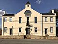
Old Gates County Courthouse in Gatesville
-
Flag of Gates County
See also
 In Spanish: Condado de Gates para niños
