Chowan County, North Carolina facts for kids
Quick facts for kids
Chowan County
|
|||
|---|---|---|---|
|
|||
|
|||
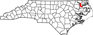
Location within the U.S. state of North Carolina
|
|||
 North Carolina's location within the U.S. |
|||
| Country | |||
| State | |||
| Founded | 1668 | ||
| Named for | Chowanoke Indian Tribe | ||
| Seat | Edenton | ||
| Largest community | Edenton | ||
| Area | |||
| • Total | 233.65 sq mi (605.2 km2) | ||
| • Land | 172.66 sq mi (447.2 km2) | ||
| • Water | 60.99 sq mi (158.0 km2) 26.10% | ||
| Population
(2020)
|
|||
| • Total | 13,708 | ||
| • Estimate
(2023)
|
13,891 | ||
| • Density | 79.39/sq mi (30.65/km2) | ||
| Time zone | UTC−5 (Eastern) | ||
| • Summer (DST) | UTC−4 (EDT) | ||
| Congressional district | 1st | ||
Chowan County (pronounced choh-WON) is one of the 100 counties in the state of North Carolina. It's a cool place with a rich history! As of the 2020 census, about 13,708 people live here. The main town and county seat is Edenton.
Chowan County was first created a long, long time ago, between 1668 and 1671. It was originally called Shaftesbury Precinct. It later became Chowan Precinct and then officially a county in 1739.
Contents
History
Chowan County was formed in 1670. It was first known as Shaftesbury. By 1685, it was renamed after the Chowan Indian tribe. This tribe lived in the northeastern part of the Carolina Colony.
Chowan County is located in the northeastern part of North Carolina. It is surrounded by the Albemarle Sound, the Chowan River, and several other counties. These counties are Bertie, Hertford, Gates, and Perquimans. The land area of the county is about 172.64 square miles.
The town of Edenton was started in 1720. It was named after Governor Charles Eden. In 1722, Edenton became the official county seat, and it still is today.
During the American Civil War, a special group of soldiers was formed here. They were called the Albemarle Artillery. They were recruited in 1862 from men in Chowan and Tyrrell counties. Their cannons were made from bronze bells donated by local churches and courthouses! Because of this, the group was renamed the Edenton Bell Battery. Their cannons had names like Columbia, St. Paul, Fannie Roulac, and Edenton.
Two of these cannons, St. Paul and Edenton, were thought to be lost for a long time. But they have been found and brought back to Edenton! You can now see them on display at Edenton's waterfront park.
Geography
Chowan County covers a total area of about 233.65 square miles. About 172.66 square miles of this is land. The rest, about 61.99 square miles, is water. This means about 26.10% of the county is water. Chowan County is the smallest county in North Carolina by land area. It is also the third smallest by total area.
Important Places to Visit
- Historic Edenton
- James Iredell House
Major Water Bodies
Neighboring Counties
- Gates County (to the north)
- Perquimans County (to the east)
- Tyrrell County (to the southeast)
- Washington County (to the south)
- Bertie County (to the west)
- Hertford County (to the northwest)
Main Roads

 Future I-87
 US 17
US 17
 US 17 Bus.
 NC 32
NC 32 NC 37
NC 37 NC 94
NC 94
Other Important Places
- Northeastern Regional Airport
People of Chowan County
| Historical population | |||
|---|---|---|---|
| Census | Pop. | %± | |
| 1790 | 4,988 | — | |
| 1800 | 5,132 | 2.9% | |
| 1810 | 5,297 | 3.2% | |
| 1820 | 6,464 | 22.0% | |
| 1830 | 6,697 | 3.6% | |
| 1840 | 6,690 | −0.1% | |
| 1850 | 6,721 | 0.5% | |
| 1860 | 6,842 | 1.8% | |
| 1870 | 6,450 | −5.7% | |
| 1880 | 7,900 | 22.5% | |
| 1890 | 9,167 | 16.0% | |
| 1900 | 10,258 | 11.9% | |
| 1910 | 11,303 | 10.2% | |
| 1920 | 10,649 | −5.8% | |
| 1930 | 11,282 | 5.9% | |
| 1940 | 11,572 | 2.6% | |
| 1950 | 12,540 | 8.4% | |
| 1960 | 11,729 | −6.5% | |
| 1970 | 10,764 | −8.2% | |
| 1980 | 12,558 | 16.7% | |
| 1990 | 13,506 | 7.5% | |
| 2000 | 14,526 | 7.6% | |
| 2010 | 14,793 | 1.8% | |
| 2020 | 13,708 | −7.3% | |
| 2023 (est.) | 13,891 | −6.1% | |
| U.S. Decennial Census 1790–1960 1900–1990 1990–2000 2010 2020 |
|||
The population of Chowan County was 13,708 people in 2020. There were 6,133 households and 3,986 families living in the county.
Back in 2010, there were 14,793 people living here. About 23.90% of the people were under 18 years old. About 17.90% were 65 years or older. The average age was 40 years old.
Communities
Town
- Edenton (This is the main town and county seat.)
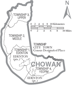
Townships (Smaller Areas)
- Township 1, Edenton
- Township 2, Middle
- Township 3, Upper
- Township 4, Yeopim
Census-designated places (CDPs)
These are areas that are like towns but are not officially incorporated.
- Arrowhead Beach
- Cape Colony
- Chowan Beach
Other Unincorporated Places
These are small communities that are not part of a town or CDP.
See also
 In Spanish: Condado de Chowan para niños
 | Tommie Smith |
 | Simone Manuel |
 | Shani Davis |
 | Simone Biles |
 | Alice Coachman |


