Hertford County, North Carolina facts for kids
Quick facts for kids
Hertford County
|
|||
|---|---|---|---|

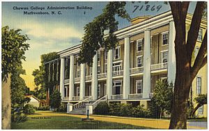
Chowan College Administration Building in Murfreesboro
|
|||
|
|||

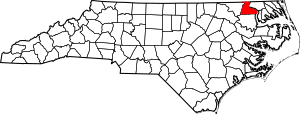
Location within the U.S. state of North Carolina
|
|||
 North Carolina's location within the U.S. |
|||
| Country | |||
| State | |||
| Founded | 1759 | ||
| Named for | Francis Seymour-Conway, 1st Marquess of Hertford | ||
| Seat | Winton | ||
| Largest community | Ahoskie | ||
| Area | |||
| • Total | 360.40 sq mi (933.4 km2) | ||
| • Land | 353.16 sq mi (914.7 km2) | ||
| • Water | 7.24 sq mi (18.8 km2) 2.01% | ||
| Population
(2020)
|
|||
| • Total | 21,552 | ||
| • Estimate
(2023)
|
19,453 | ||
| • Density | 61.03/sq mi (23.56/km2) | ||
| Time zone | UTC−5 (Eastern) | ||
| • Summer (DST) | UTC−4 (EDT) | ||
| Congressional district | 1st | ||
Hertford County is a county in North Carolina, a state in the United States. In 2020, about 21,552 people lived here. The main town and county seat is Winton. Hertford County is part of a region called the Inner Banks.
Contents
History of Hertford County
Hertford County is the home of the Meherrin Indian Tribe. These are descendants of the first people who lived in this area for many hundreds of years. In 1706, the Meherrin Tribe moved from Virginia. They settled on land that another tribe, the Chowanoke, had left.
This land was a six-square-mile area near the Meherrin River. A special agreement, called a treaty, confirmed their right to this land in 1726. Today, the Meherrin Tribe has about 900 members. Most of them live close to their old reservation land. The tribe holds an annual Pow Wow at the end of October.
The county was officially created in 1759. It was formed from parts of Bertie, Chowan, and Northampton counties. It was named after Francis Seymour-Conway, 1st Marquess of Hertford. The county court first met at Cotton's Ferry. Later, in 1766, the town of Winton became the official county seat. In 1779, parts of Hertford County helped form Gates County.
Geography and Nature
Hertford County covers about 360 square miles. Most of this area, about 353 square miles, is land. The rest, about 7 square miles, is water.
Protected Natural Areas
- Chowan Swamp Game Land (part of it is in Hertford County)
Rivers and Streams
Many important water bodies flow through Hertford County:
- Ahoskie River
- Cutawhiskie Creek
- Chowan River
- Indian Creek
- Meherrin River
- Panther Creek
- Potecasi Creek
- Tukey Creek
- Wiccacon River
Neighboring Counties
Hertford County shares borders with several other counties:
- Southampton County, Virginia – to the north
- Gates County – to the east
- Chowan County – to the southeast
- Bertie County – to the south
- Northampton County – to the west
Main Roads and Transportation
 US 13
US 13 US 158


 US 158 Bus.
 US 258
 NC 11
NC 11 NC 35
NC 35 NC 42
NC 42 NC 45
NC 45 NC 305
 NC 461
 NC 561
Key Infrastructure
- Parker's Ferry: This is a river ferry that crosses the Meherrin River.
People and Population
| Historical population | |||
|---|---|---|---|
| Census | Pop. | %± | |
| 1790 | 5,949 | — | |
| 1800 | 6,701 | 12.6% | |
| 1810 | 6,052 | −9.7% | |
| 1820 | 7,712 | 27.4% | |
| 1830 | 8,537 | 10.7% | |
| 1840 | 7,484 | −12.3% | |
| 1850 | 8,142 | 8.8% | |
| 1860 | 9,504 | 16.7% | |
| 1870 | 9,273 | −2.4% | |
| 1880 | 11,843 | 27.7% | |
| 1890 | 13,851 | 17.0% | |
| 1900 | 14,294 | 3.2% | |
| 1910 | 15,436 | 8.0% | |
| 1920 | 16,294 | 5.6% | |
| 1930 | 17,542 | 7.7% | |
| 1940 | 19,352 | 10.3% | |
| 1950 | 21,453 | 10.9% | |
| 1960 | 22,718 | 5.9% | |
| 1970 | 23,529 | 3.6% | |
| 1980 | 23,368 | −0.7% | |
| 1990 | 22,523 | −3.6% | |
| 2000 | 22,601 | 0.3% | |
| 2010 | 24,669 | 9.2% | |
| 2020 | 21,552 | −12.6% | |
| 2023 (est.) | 19,453 | −21.1% | |
| U.S. Decennial Census 1790–1960 1900–1990 1990–2000 2010 2020 |
|||
Population in 2020
In 2020, the census counted 21,552 people living in Hertford County. There were 8,845 households and 5,419 families.
| Race | Number | Percentage |
|---|---|---|
| White (non-Hispanic) | 6,721 | 31.19% |
| Black or African American (non-Hispanic) | 12,215 | 56.68% |
| Native American | 188 | 0.87% |
| Asian | 113 | 0.52% |
| Pacific Islander | 3 | 0.01% |
| Other/Mixed | 733 | 3.4% |
| Hispanic or Latino | 1,579 | 7.33% |
Economy and Jobs
Hertford County has several big employers. These include a federal prison, Chowan University, and a Nucor steel mill. There are also several Perdue chicken processing plants. An aluminum factory is in Winton, and a lumber factory is in Ahoskie.
These industries, along with local shops and restaurants, help the county's economy. Hertford County often has one of the lowest unemployment rates in Northeastern North Carolina.
Education System
Hertford County Public Schools manages seven schools. These schools serve students from pre-kindergarten up to twelfth grade. There are three high schools, including Hertford County High School. There is also one middle school and three elementary schools.
Media and News
Hertford County gets its local news from the Roanoke-Chowan News-Herald newspaper. There are also five radio stations in the county. WDLZ FM 98.3 and WWDR AM 1080 are in Murfreesboro. WQDK FM 99.3 and WRCS AM 970 are in Ahoskie. WBKU FM 91.7, a Christian music station, is also in Ahoskie.
Towns and Communities
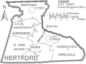
Towns in Hertford County
- Ahoskie (This is the largest community)
- Como
- Harrellsville
- Murfreesboro
- Winton (This is the county seat)
Census-Designated Place
Townships
- Ahoskie
- Harrellsville
- Maneys Neck
- Murfreesboro
- St. John's
- Winton
See also
 In Spanish: Condado de Hertford para niños
 | Roy Wilkins |
 | John Lewis |
 | Linda Carol Brown |


