Southampton County, Virginia facts for kids
Quick facts for kids
Southampton County
|
||
|---|---|---|

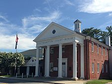
Southampton County Courthouse
|
||
|
||

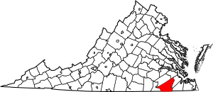
Location within the U.S. state of Virginia
|
||
 Virginia's location within the U.S. |
||
| Country | ||
| State | ||
| Founded | 1749 | |
| Named for | either Southampton, England, or Henry Wriothesley, 3rd Earl of Southampton | |
| Seat | Courtland | |
| Largest town | Courtland | |
| Area | ||
| • Total | 602 sq mi (1,560 km2) | |
| • Land | 599 sq mi (1,550 km2) | |
| • Water | 3.2 sq mi (8 km2) 0.5% | |
| Population
(2020)
|
||
| • Total | 17,996 | |
| • Density | 29.894/sq mi (11.542/km2) | |
| Time zone | UTC−5 (Eastern) | |
| • Summer (DST) | UTC−4 (EDT) | |
| Congressional districts | 4th, 2nd | |
Southampton County is a county located in the southern part of Virginia. It shares its southern border with North Carolina. In 2020, about 17,996 people lived here. The main town and county seat is Courtland.
Contents
History of Southampton County
In the 1600s, after the Jamestown settlement was founded in 1607, English settlers started exploring and moving into areas near Hampton Roads. By 1634, the English colony of Virginia was divided into eight areas called shires. Most of what is now Southampton County was first part of a shire called Warrosquyoake. These shires soon became known as counties. Warrosquyoake Shire was later renamed Isle of Wight County in 1637.
In 1749, the part of Isle of Wight County that was west of the Blackwater River became Southampton County. Later, a piece of Nansemond County was added. That area is now the Independent City of Suffolk.
In August 1831, an enslaved man named Nat Turner led a rebellion of enslaved people in Southampton County. The rebellion was stopped, and Turner and others involved were executed.
Southampton County might have been named after Southampton, a big city in England. Another idea is that it was named for Henry Wriothesley, 3rd Earl of Southampton. He was one of the people who helped start the Virginia Company and supported setting up colonies in North America.
Geography of Southampton County
Southampton County covers a total area of about 602 square miles (1,559 km2). Most of this is land, with about 599 square miles (1,551 km2) being land and 3.2 square miles (8.3 km2) being water.
The Blackwater River forms the eastern border of Southampton County, and the Meherrin River is on its western side. The Nottoway River flows right through the middle of the county. All three of these rivers flow into the Chowan River, which then goes south into Albemarle Sound in North Carolina. The Blackwater River separates Southampton County from Isle of Wight County. The Meherrin River separates it from Greensville County.
Neighboring Counties
Southampton County is bordered by several other counties and cities:
- Surry County to the north
- Isle of Wight County to the northeast
- City of Franklin to the east
- City of Suffolk to the southeast
- Hertford County, North Carolina to the south
- Northampton County, North Carolina to the southwest
- Greensville County to the west
- Sussex County to the northwest
Main Roads
These are some of the major highways that run through Southampton County:
 US 58
US 58 US 258
 US 460
 SR 35
SR 35 SR 186
 SR 189
Population and People
| Historical population | |||
|---|---|---|---|
| Census | Pop. | %± | |
| 1790 | 12,864 | — | |
| 1800 | 13,925 | 8.2% | |
| 1810 | 13,497 | −3.1% | |
| 1820 | 14,170 | 5.0% | |
| 1830 | 16,074 | 13.4% | |
| 1840 | 14,525 | −9.6% | |
| 1850 | 13,521 | −6.9% | |
| 1860 | 12,915 | −4.5% | |
| 1870 | 12,285 | −4.9% | |
| 1880 | 18,012 | 46.6% | |
| 1890 | 20,078 | 11.5% | |
| 1900 | 22,848 | 13.8% | |
| 1910 | 26,302 | 15.1% | |
| 1920 | 27,555 | 4.8% | |
| 1930 | 26,870 | −2.5% | |
| 1940 | 26,442 | −1.6% | |
| 1950 | 26,522 | 0.3% | |
| 1960 | 27,195 | 2.5% | |
| 1970 | 18,582 | −31.7% | |
| 1980 | 18,731 | 0.8% | |
| 1990 | 17,550 | −6.3% | |
| 2000 | 17,482 | −0.4% | |
| 2010 | 18,570 | 6.2% | |
| 2020 | 17,996 | −3.1% | |
| U.S. Decennial Census 1790–1960 1900–1990 1990–2000 2010–2020 |
|||
2020 Census Information
The 2020 census showed that Southampton County had a population of 17,996 people. Here's a look at the different groups living in the county:
| Race / Ethnicity | Pop 2010 | Pop 2020 | % 2010 | % 2020 |
|---|---|---|---|---|
| White alone (NH) | 11,138 | 10,959 | 59.98% | 60.90% |
| Black or African American alone (NH) | 6,893 | 5,908 | 37.12% | 32.83% |
| Native American or Alaska Native alone (NH) | 52 | 56 | 0.28% | 0.31% |
| Asian alone (NH) | 46 | 67 | 0.25% | 0.37% |
| Pacific Islander alone (NH) | 5 | 20 | 0.03% | 0.11% |
| Some Other Race alone (NH) | 13 | 50 | 0.07% | 0.28% |
| Mixed Race/Multi-Racial (NH) | 220 | 604 | 1.18% | 3.36% |
| Hispanic or Latino (any race) | 203 | 332 | 1.09% | 1.84% |
| Total | 18,570 | 17,996 | 100.00% | 100.00% |
2010 Census Information
In 2010, there were 18,570 people living in Southampton County. The county had about 29 people per square mile. About 60.4% of the people were White, and 37.2% were Black or African American. About 1.1% of the population was Hispanic or Latino.
The population was spread out by age. About 22.7% were under 18 years old, and 14.2% were 65 years or older. The average age was 39 years.
Public Services
The Blackwater Regional Library system provides library services to the people of Southampton County.
Communities in Southampton County
Towns
Census-Designated Places
These are areas that are like towns but are not officially incorporated:
Other Unincorporated Communities
These are smaller communities that are not part of a town or census-designated place:
- Berlin
- Black Creek
- Drewryville
Famous People from Southampton County
- Bill Bailey: A famous tap dancer. He was the first person known to do the "moonwalk" dance. He was also the older brother of actress and singer Pearl Bailey.
- John Brown: A person who escaped slavery.
- Samuel Butts: An officer in the US Army.
- Anthony W. Gardiner: The ninth president of Liberia. Liberia was a colony in West Africa created for free Black people. Anthony W. Gardiner moved there from Southampton County.
- S. Bernard Goodwyn: The chief justice of the Supreme Court of Virginia.
- William Mahone: A person who built railroads, was a U.S. Senator, and a general for the Confederacy.
- Dred Scott: An enslaved man famous for the Dred Scott Decision by the U.S. Supreme Court. This decision limited the rights of African Americans at the time.
- George Henry Thomas: A general in the US Army.
- Nat Turner: The leader of a rebellion of enslaved people.
See also
 In Spanish: Condado de Southampton para niños
 | James Van Der Zee |
 | Alma Thomas |
 | Ellis Wilson |
 | Margaret Taylor-Burroughs |


