
Northampton County, North Carolina facts for kids
Quick facts for kids
Northampton County
|
|||||
|---|---|---|---|---|---|

Northampton County Courthouse in Jackson
|
|||||
|
|||||
| Motto(s):
"Living is Easy"
"Rich Tradition" |
|||||

Location within the U.S. state of North Carolina
|
|||||
 North Carolina's location within the U.S. |
|||||
| Country | |||||
| State | |||||
| Founded | 1741 | ||||
| Named for | James Compton, 5th Earl of Northampton | ||||
| Seat | Jackson | ||||
| Largest community | Gaston | ||||
| Area | |||||
| • Total | 550.56 sq mi (1,425.9 km2) | ||||
| • Land | 536.70 sq mi (1,390.0 km2) | ||||
| • Water | 13.86 sq mi (35.9 km2) 2.52% | ||||
| Population
(2020)
|
|||||
| • Total | 17,471 | ||||
| • Estimate
(2023)
|
16,715 | ||||
| • Density | 32.55/sq mi (12.57/km2) | ||||
| Time zone | UTC−5 (Eastern) | ||||
| • Summer (DST) | UTC−4 (EDT) | ||||
| Congressional district | 1st | ||||


Northampton County (pronounced nor-THAMP-tən) is a county in the state of North Carolina. In 2020, about 17,471 people lived there. The main town and county seat (where the county government is) is Jackson.
Northampton County is part of a larger area called the Roanoke Rapids Micropolitan Statistical Area. This area helps describe how towns and counties are connected for things like jobs and travel.
Contents
History of Northampton County
Early Beginnings
The area that is now Northampton County was first set up by English colonists. It was known as the Albemarle Precinct. In 1729, a part of Albemarle was separated to create Bertie County.
Northampton County was officially formed in 1741. It was made from a part of Bertie County. The county was named after James Compton, 5th Earl of Northampton. Later, in 1759, parts of Northampton, Bertie, and Chowan County were combined to form Hertford County.
Voting Rights History
In 1959, Northampton County was involved in an important case about voting rights. This case went all the way to the U.S. Supreme Court. The county was defending the use of a "literacy test" for voting. This test required people to prove they could read and write before they could vote.
The Supreme Court said that these tests were allowed if they were given fairly to everyone, no matter their race. However, the National Voting Rights Act of 1965 later made it illegal to use such tests. This law helped make sure everyone had an equal chance to vote.
Geography and Nature
Northampton County covers about 550 square miles. Most of this area, about 537 square miles, is land. The rest, about 14 square miles, is water.
Important Waterways
The county has many important rivers, swamps, and lakes. These waterways are key for the local environment and for people's activities.
Some of the major water bodies include:
- Lake Gaston
- Meherrin River
- Roanoke Rapids Lake
- Roanoke River
- Bull Neck Swamp
- Corduroy Swamp
- Doolittle Millpond
- Gumberry Swamp
- Occoneechee Creek
- Paddys Delight Creek
- Potecasi Creek
- Ramsey Creek
- Taylors Millpond
- Urahaw Swamp
Nearby Counties
Northampton County shares borders with several other counties:
- To the north: Greensville County, Virginia and Brunswick County, Virginia
- To the northeast: Southampton County, Virginia
- To the east: Hertford County
- To the southeast: Bertie County
- To the southwest: Halifax County
- To the northwest: Warren County
Main Roads
Several important highways pass through Northampton County. These roads help people travel and transport goods.
 I-95
I-95 US 158


US 158 Byp. (a bypass around Garysburg) US 258
 US 301
 NC 35
NC 35 NC 46
NC 46 NC 48
NC 48 NC 186
 NC 305
 NC 308
 NC 561
Population and People
How Many People Live Here?
The number of people living in Northampton County has changed over time.
| Historical population | |||
|---|---|---|---|
| Census | Pop. | %± | |
| 1790 | 9,992 | — | |
| 1800 | 12,353 | 23.6% | |
| 1810 | 13,082 | 5.9% | |
| 1820 | 13,242 | 1.2% | |
| 1830 | 13,391 | 1.1% | |
| 1840 | 13,369 | −0.2% | |
| 1850 | 13,335 | −0.3% | |
| 1860 | 13,372 | 0.3% | |
| 1870 | 14,749 | 10.3% | |
| 1880 | 20,032 | 35.8% | |
| 1890 | 21,242 | 6.0% | |
| 1900 | 21,150 | −0.4% | |
| 1910 | 22,323 | 5.5% | |
| 1920 | 23,184 | 3.9% | |
| 1930 | 27,161 | 17.2% | |
| 1940 | 28,299 | 4.2% | |
| 1950 | 28,432 | 0.5% | |
| 1960 | 26,811 | −5.7% | |
| 1970 | 24,009 | −10.5% | |
| 1980 | 22,584 | −5.9% | |
| 1990 | 20,798 | −7.9% | |
| 2000 | 22,086 | 6.2% | |
| 2010 | 22,099 | 0.1% | |
| 2020 | 17,471 | −20.9% | |
| 2023 (est.) | 16,715 | −24.4% | |
| U.S. Decennial Census 1790–1960 1900–1990 1990–2000 2010 2020 |
|||
In 2020, there were 17,471 people living in the county. There were also 8,547 households and 5,610 families.
Who Lives in Northampton County?
The people of Northampton County come from different backgrounds.
| Group | Number | Percentage |
|---|---|---|
| White (not Hispanic) | 6,835 | 39.12% |
| Black or African American (not Hispanic) | 9,649 | 55.23% |
| Native American | 43 | 0.25% |
| Asian | 27 | 0.15% |
| Pacific Islander | 4 | 0.02% |
| Other/Mixed | 560 | 3.21% |
| Hispanic or Latino | 353 | 2.02% |
In 2010, about 58.4% of the people were Black or African American. About 39.2% were White. Other groups included Native American, Asian, and people of two or more races. About 1.4% of the population was Hispanic or Latino.
Education in Northampton County
The schools in Northampton County are managed by the North Carolina Department of Public Instruction. In the 2021–2022 school year, the county's school system was rated as "low-performing." This happens if most of its schools receive a low grade (D or F).
Here's how some of the schools were rated:
- Central Elementary: D
- Willis Hare Elementary: F
- Gaston STEM Leadership Academy: F
- Conway Middle: D (but it did better than expected)
- Northampton Early College: B (this school did not have expectations set)
- Northampton County High School: D (it did not meet expectations)
- Northampton Virtual Academy: Not rated
Communities and Towns
Northampton County has several towns and smaller communities.

Towns in the County
- Conway
- Garysburg
- Gaston (This is the largest community in the county)
- Jackson (This is the county seat)
- Lasker
- Rich Square
- Seaboard
- Severn
- Woodland
Smaller Communities
These communities are not officially towns but are important parts of the county:
County Divisions (Townships)
The county is also divided into smaller areas called townships. These help with local administration.
- Gaston
- Jackson
- Kirby
- Occoneechee
- Pleasant Hill
- Rich Square
- Roanoke
- Seaboard
- Wiccanee
Images for kids
-
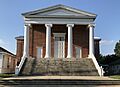
Northampton County Courthouse in Jackson
-
Seal of Northampton County
-

Northampton County logo
-

Northampton County Flag
See also
 In Spanish: Condado de Northampton (Carolina del Norte) para niños
