Roanoke River facts for kids
Quick facts for kids Roanoke River |
|
|---|---|

|
|

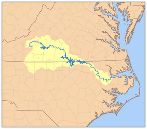
Map of the Roanoke River watershed
|
|
| Other name(s) | Staunton River |
| Country | United States |
| State | Virginia, North Carolina |
| Physical characteristics | |
| Main source | Confluence of North and South Forks Lafayette, Virginia 1,194 ft (364 m) 37°14′15″N 80°12′49″W / 37.23750°N 80.21361°W |
| River mouth | Albemarle Sound Plymouth, North Carolina 0 ft (0 m) 35°56′33″N 76°41′42″W / 35.94250°N 76.69500°W |
| Length | 410 mi (660 km) |
| Basin features | |
| Basin size | 9,680 sq mi (25,100 km2) |
| Tributaries |
|
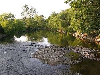
The Roanoke River is a big river in the United States. It flows through southern Virginia and northeastern North Carolina. The river is about 410 miles (660 km) long. It starts near the Appalachian Mountains and flows southeast through flat lands called the coastal plain and rolling hills called the Piedmont. Finally, it empties into Albemarle Sound.
This river has been very important throughout American history. It was a key place for early settlements in the Virginia Colony and the Carolina Colony. A part of the river in Virginia, about 81 miles (130 km) long, is also known as the Staunton River. This section is between Leesville Lake and Kerr Lake. The Roanoke River has several large dams that create a chain of lakes.
The name "Staunton River" is also used for a political area in Pittsylvania County, Virginia. Here, a large part of the river forms the border between Campbell County to the north and Pittsylvania County to the south.
Contents
Where the Roanoke River Flows
The Roanoke River begins in the Blue Ridge Mountains in southwestern Virginia. It starts where two smaller streams, the North Fork and the South Fork, join together near Lafayette in Montgomery County.
North and South Forks
The North Fork is about 30 miles (48 km) long. It starts between two mountain ridges and flows southwest, then turns back to the northeast. The South Fork is about 20 miles (32 km) long. It begins from several streams in the mountains near the borders of Floyd, Roanoke, and Montgomery counties. It generally flows north before joining the North Fork.
Journey to the Sea
After the two forks meet, the river flows northeast through the Roanoke Valley. It passes through the city of Roanoke. Then, it goes through a narrow gorge in the Blue Ridge Mountains. This part of the river forms the border between Franklin and Bedford counties.
The river then flows east-southeast across the Piedmont region of southern Virginia. It enters northeastern North Carolina, passing north of Roanoke Rapids. The river continues southeast through the Roanoke River National Wildlife Refuge. Finally, it turns north for a short distance as it enters Batchelor Bay, which is part of Albemarle Sound.
Dams and Lakes on the River
The Roanoke River has six dams along its course. These dams create large lakes or reservoirs.
Major Dams
- The first dam is the Niagara Dam, located south of the city of Roanoke. It was built in 1906 to provide power for a streetcar system. Today, Appalachian Power owns and operates it.
- Further downstream, two dams create the Smith Mountain Lake and Leesville Lake reservoirs. These are in the Piedmont region of southwestern Virginia.
- Near the North Carolina border, the John H. Kerr Dam forms the very large Kerr Lake.
- In northeastern North Carolina, about 3 miles (4.8 km) west of Roanoke Rapids, the river is dammed to create Lake Gaston.
- The last dam creates Roanoke Rapids Lake.
These dams help control the river's flow and provide power.
History of the Roanoke River
The valley of the Roanoke River was home to many Native American groups. These included the Occaneechi and the Tutelo. The name "Roanoke" comes from an Algonquian word, rawrenok, which means wampum. Because of its powerful and often dangerous spring floods, the river was sometimes called the "River of Death."
Early Settlements
People from Virginia began settling the lower parts of the river valley in the mid-1600s. This area was known as the Albemarle Settlements. Fur traders explored the upper parts of the Roanoke River in the late 1600s. However, English settlers did not move into these higher areas until the early 1700s.
Roanoke City's Name
In 1883, a small town called Big Lick was chosen as a major hub for the new Norfolk and Western Railway. This railway was set to meet the Shenandoah Valley Railroad there. Big Lick was then renamed Roanoke after the river that flowed through it. The surrounding Roanoke County had already been named after the river in 1838.
Controlling Floods
Before the John H. Kerr Dam was finished in 1953, the Roanoke River often had very serious floods. A big hurricane in 1940 caused record-breaking floods in the Roanoke River basin. This event led to strong calls for better ways to control the river's flooding. The construction of the John H. Kerr Dam helped to prevent such large floods in the future.
 In Spanish: Río Roanoke para niños
 | Stephanie Wilson |
 | Charles Bolden |
 | Ronald McNair |
 | Frederick D. Gregory |


