Franklin County, Virginia facts for kids
Quick facts for kids
Franklin County
|
|
|---|---|

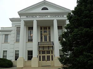
Franklin County Courthouse in May 2010
|
|

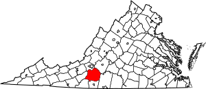
Location within the U.S. state of Virginia
|
|
 Virginia's location within the U.S. |
|
| Country | |
| State | |
| Founded | 1785 |
| Named for | Benjamin Franklin |
| Seat | Rocky Mount |
| Largest town | Rocky Mount |
| Area | |
| • Total | 712 sq mi (1,840 km2) |
| • Land | 690 sq mi (1,800 km2) |
| • Water | 21 sq mi (50 km2) 3.0% |
| Population
(2020)
|
|
| • Total | 54,477 |
| • Density | 77/sq mi (30/km2) |
| Time zone | UTC−5 (Eastern) |
| • Summer (DST) | UTC−4 (EDT) |
| Congressional district | 9th |
Franklin County is a place in the Blue Ridge foothills of Virginia. It is a county in the United States. In 2020, about 54,477 people lived there.
The main town, or county seat, is Rocky Mount. Franklin County is part of the larger Roanoke area. The Roanoke River forms its border with Bedford County to the northeast.
Contents
History of Franklin County
Long ago, Native American tribes lived in the Blue Ridge Foothills. Most of these tribes spoke a language called Siouan.
A few European settlers moved to the area before the American Revolutionary War. But most people came after the war. They were looking for new land because growing tobacco had worn out the soil in eastern Virginia.
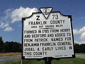
Franklin County was created in 1785. It was formed from parts of Bedford and Henry counties. The county was named after Benjamin Franklin, a famous American leader. Many of the new settlers were Scots-Irish. There were also free people of color who moved to this frontier area. They wanted to escape the strict rules of Virginia's slave society.
The "Moonshine Capital" Era
In the 1900s, during a time called Prohibition, it was against the law to make or sell alcohol. People in Franklin County became very good at making and selling homemade alcohol, often called "moonshine." This activity became a big part of the local economy. Some people even called Franklin County the "Moonshine Capital of the World."
Historians believe that in the 1920s, almost everyone in Franklin County was involved in this illegal trade. This included some local law enforcement officials. In 1935, a big federal investigation led to trials for 34 people. This event was known as the "Great Moonshine Conspiracy." It gained national attention.
The trial was the longest in Virginia's history at that time. Thirty-one people were found guilty. However, most of them received light sentences, like two years or less in jail. Some were only given probation.
This period has been featured in books and movies. T. Keister Greer wrote a history book about the trial. A writer named Matt Bondurant wrote a novel called The Wettest County in the World (2008). This book was based on his ancestors' experiences during this time. The book was later made into a movie called Lawless in 2012.
Recent History
Since the 1980s, many homes have been built around Smith Mountain Lake. People who work in nearby cities like Roanoke and Lynchburg live here. Many retired people have also moved to the area. These changes have helped the county's population grow.
Geography
Franklin County covers about 712 square miles. About 690 square miles are land, and 21 square miles are water. This means about 3% of the county is water. The county is located upstream from the fall line of the Roanoke River.
Districts
The county is divided into different areas called supervisor districts. Some of these are:
- Blackwater
- Blue Ridge
- Boones Mill
- Gills Creek
- Rocky Mount
- Snow Creek
- Union Hall
- Ferrum
- Glade Hill
- Penhook
- Callaway
Neighboring Counties
Franklin County shares borders with these counties:
- Bedford County, Virginia — to the northeast
- Pittsylvania County, Virginia — to the southeast
- Henry County, Virginia — to the south
- Patrick County, Virginia — to the southwest
- Floyd County, Virginia — to the west
- Roanoke County, Virginia — to the northwest
Protected Natural Areas
- Blue Ridge Parkway (part of it)
- Booker T. Washington National Monument
Main Roads
 I-73 (future road)
 US 220
 SR 40
SR 40 SR 116
 SR 122
Population Information
| Historical population | |||
|---|---|---|---|
| Census | Pop. | %± | |
| 1790 | 6,842 | — | |
| 1800 | 9,302 | 36.0% | |
| 1810 | 10,724 | 15.3% | |
| 1820 | 12,017 | 12.1% | |
| 1830 | 14,911 | 24.1% | |
| 1840 | 15,832 | 6.2% | |
| 1850 | 17,430 | 10.1% | |
| 1860 | 20,098 | 15.3% | |
| 1870 | 18,264 | −9.1% | |
| 1880 | 25,084 | 37.3% | |
| 1890 | 24,985 | −0.4% | |
| 1900 | 25,953 | 3.9% | |
| 1910 | 26,480 | 2.0% | |
| 1920 | 26,283 | −0.7% | |
| 1930 | 24,337 | −7.4% | |
| 1940 | 25,864 | 6.3% | |
| 1950 | 24,560 | −5.0% | |
| 1960 | 25,925 | 5.6% | |
| 1970 | 26,858 | 3.6% | |
| 1980 | 35,740 | 33.1% | |
| 1990 | 39,549 | 10.7% | |
| 2000 | 47,286 | 19.6% | |
| 2010 | 56,159 | 18.8% | |
| 2020 | 54,477 | −3.0% | |
| U.S. Decennial Census 1790-1960 1900-1990 1990-2000 2010 2020 |
|||
2020 Census Details
The table below shows the different groups of people living in Franklin County in 2010 and 2020.
| Race / Ethnicity (NH = Non-Hispanic) | Pop 2010 | Pop 2020 | % 2010 | % 2020 |
|---|---|---|---|---|
| White alone (NH) | 49,072 | 46,218 | 87.38% | 84.84% |
| Black or African American alone (NH) | 4,541 | 3,848 | 8.09% | 7.06% |
| Native American or Alaska Native alone (NH) | 112 | 75 | 0.20% | 0.14% |
| Asian alone (NH) | 251 | 303 | 0.45% | 0.56% |
| Pacific Islander alone (NH) | 10 | 20 | 0.02% | 0.04% |
| Some Other Race alone (NH) | 144 | 153 | 0.26% | 0.28% |
| Mixed Race or Multi-Racial (NH) | 605 | 1,905 | 1.08% | 3.50% |
| Hispanic or Latino (any race) | 1,424 | 1,955 | 2.54% | 3.59% |
| Total | 56,159 | 54,477 | 100.00% | 100.00% |
Communities
Towns
Census-designated places
These are areas that are like towns but are not officially incorporated as towns.
Other Unincorporated Communities
These are smaller communities that are not officially part of a town or census-designated place.
- Burnt Chimney
- Callaway
- Glade Hill
- Hale's Ford
- Naff
- Redwood
- Snow Creek
- Wirtz
- Fork Mountain
Notable People from Franklin County
- Jubal Anderson Early: A general who fought for the Confederacy during the American Civil War.
- Booker T. Washington: He was born on a farm in Hale's Ford. He was a freedman (a former slave) who became a very important educator and civil rights activist.
- Adam Clayton Powell Sr. (1865–1953): A well-known Baptist minister. He was born to a free woman of color whose family had been free for many generations. He worked hard to go to college and graduate school at Yale University. He later led the Abyssinian Baptist Church in Harlem, New York, which became the largest church in the U.S. at that time.
- Bondurant Brothers (Howard, Forrest, and Jack): These brothers were involved in making and selling homemade alcohol during the Prohibition Era. They lived in the Snow Creek Area. Their story inspired Matt Bondurant's novel, The Wettest County in the World, and the movie Lawless.
- Ron Hodges: A professional baseball catcher who played for the New York Mets from 1973 to 1984.
- Dwaine Board: A former National Football League player and coach. He won four Super Bowls with the San Francisco 49ers.
- Jesse L. Martin: An actor famous for his role as Detective Ed Green on the TV show Law & Order.
- Tarell Basham: A professional football player who plays as an outside linebacker for the Dallas Cowboys.
In Popular Culture
- Franklin County is the setting for Matt Bondurant's novel, The Wettest County in the World (2008). This book is about the Prohibition era and features his family members.
- The county is also featured in the movie Lawless (2012). This film was based on Bondurant's novel.
- Franklin County, especially Smith Mountain Lake, was the setting for the 1991 movie "What About Bob?". This comedy film starred Bill Murray and Richard Dreyfuss.
- The novella Alien Bootlegger by Rebecca Ore is also set in Franklin County.
See also
 In Spanish: Condado de Franklin (Virginia) para niños
 | Toni Morrison |
 | Barack Obama |
 | Martin Luther King Jr. |
 | Ralph Bunche |


