Floyd County, Virginia facts for kids
Quick facts for kids
Floyd County
|
|||||
|---|---|---|---|---|---|
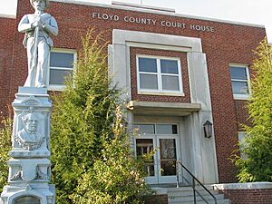
Floyd County Courthouse and Confederate Monument
|
|||||
|
|||||
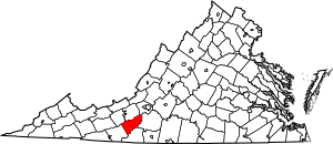
Location within the U.S. state of Virginia
|
|||||
 Virginia's location within the U.S. |
|||||
| Country | |||||
| State | |||||
| Founded | 1831 | ||||
| Named for | John Floyd | ||||
| Seat | Floyd | ||||
| Largest town | Floyd | ||||
| Area | |||||
| • Total | 382 sq mi (990 km2) | ||||
| • Land | 381 sq mi (990 km2) | ||||
| • Water | 0.9 sq mi (2 km2) 0.2% | ||||
| Population
(2020)
|
|||||
| • Total | 15,476 |
||||
| • Density | 41/sq mi (16/km2) | ||||
| Time zone | UTC−5 (Eastern) | ||||
| • Summer (DST) | UTC−4 (EDT) | ||||
| Congressional district | 9th | ||||
Floyd County is a county in the state of Virginia. In 2020, about 15,476 people lived there. The main town and county seat is Floyd. This county is part of the Blacksburg-Christiansburg area.
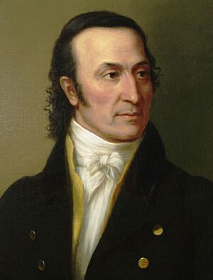
Floyd County was created in 1831. It was named after John Floyd, who was the Governor of Virginia at that time. The county is located high up in the Blue Ridge Mountains. The Little River flows around it. In the 1960s and 1970s, many people who wanted to live closer to nature moved to Floyd County.
Contents
History of Floyd County

The story of Floyd County began in the 1700s. At that time, traders, trappers, and hunters explored this part of Southwest Virginia. One of the first paths through the area was called the Trader's Path. It helped people travel from east to west.
Early Settlements
People first tried to settle here in the 1740s. In 1745, James Patton received a large land grant. This grant was for 100,000 acres (about 400 square kilometers) near the New River. Other groups also received land grants, which led to competition to settle the area. Land surveys began in the late 1740s.
Founding the County
On January 15, 1831, the government of Virginia officially created Floyd County. It was formed from a part of Montgomery County. The county was named after John Floyd, who was the Governor of Virginia. The county's first courthouse was finished in 1834. Later, in 1870, a part of Franklin County was added to Floyd County.
Important people served the county early on. William Ballard Preston, a nephew of John Floyd, was the first Commonwealth's Attorney. This job is like a chief prosecutor. Later, Jubal Early, who became a general in the Confederate States Army, also held this position.
The Town of Floyd
The main town of Floyd County was first named Jacksonville. This was to honor Andrew Jackson, who was the seventh President of the United States. Jacksonville became an official town in 1858. It was re-established in 1892 with larger boundaries. On January 23, 1896, the town's name was officially changed from Jacksonville to Floyd.
Modern Times
In the 1960s and 1970s, Floyd County became a popular place for people who wanted to live a simpler life. They wanted to be closer to nature.
Floyd County is close to the cities of Roanoke and Blacksburg-Christiansburg. This has helped its population grow slowly. Many bloggers live in the county and share their thoughts about the community.
Floyd County is also known for its lively music and writing scene. Several places in Floyd offer live music on weekends. You can hear traditional styles like Bluegrass and Old-time music. The Friday Night Jamboree at The Floyd Country Store is very famous. Both The Floyd Country Store and County Sales are part of "The Crooked Road," a music trail in Virginia. In the early 2000s, Floyd became home to FloydFest, a yearly world music festival. The Alum Ridge Boys & Ashlee, an old-time string band from Floyd County, won first prize at the 85th Annual Old Fiddlers' Convention.
The Chateau Morrisette and Villa Appalaccia wineries have also been around since the 1980s.
Geography of Floyd County
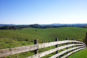
Floyd County covers about 381.8 square miles (989 square kilometers). Most of this is land, with a small amount of water. It is located in the Blue Ridge Mountains of southwestern Virginia.
The town of Floyd, the county seat, is about 40 miles (64 km) southwest of Roanoke. Buffalo Mountain is the highest point in the county. It stands at 3,971 feet (1,210 meters) tall.
Floyd County sits on a high plateau in the Blue Ridge Mountains. This plateau divides rivers that flow east from those that flow west. No streams flow into Floyd County. Instead, all the water flows out of the county. The Little River and its smaller streams drain most of the county. This water eventually flows into the New River, then the Kanawha River, the Ohio River, the Mississippi River, and finally into the Gulf of Mexico.
The Little River has three main parts: the East, West, and South forks. The South Fork is also called Dodd's Creek.
The headwaters of the south fork of the Roanoke River are in the northeastern part of the county. Shooting Creek is a very fast stream, named for how quickly it flows over rocks. This creek follows Shooting Creek Road from Floyd into Franklin County.
Neighboring Counties
Floyd County shares borders with these other counties:
- Franklin County, Virginia – to the east
- Patrick County, Virginia – to the southeast
- Carroll County, Virginia – to the southwest
- Pulaski County, Virginia – to the northwest
- Montgomery County, Virginia – to the northwest
- Roanoke County, Virginia – to the north
Protected Natural Areas
- Blue Ridge Parkway (part), including Rocky Knob Recreation Area (part)
- Buffalo Mountain Natural Area Preserve
Main Roads
 US 221
 SR 8
SR 8 US 58
US 58
Population Information
| Historical population | |||
|---|---|---|---|
| Census | Pop. | %± | |
| 1840 | 4,453 | — | |
| 1850 | 6,458 | 45.0% | |
| 1860 | 8,236 | 27.5% | |
| 1870 | 9,824 | 19.3% | |
| 1880 | 13,255 | 34.9% | |
| 1890 | 14,405 | 8.7% | |
| 1900 | 15,388 | 6.8% | |
| 1910 | 14,092 | −8.4% | |
| 1920 | 13,115 | −6.9% | |
| 1930 | 11,698 | −10.8% | |
| 1940 | 11,967 | 2.3% | |
| 1950 | 11,351 | −5.1% | |
| 1960 | 10,462 | −7.8% | |
| 1970 | 9,775 | −6.6% | |
| 1980 | 11,563 | 18.3% | |
| 1990 | 12,005 | 3.8% | |
| 2000 | 13,874 | 15.6% | |
| 2010 | 15,279 | 10.1% | |
| 2020 | 15,476 | 1.3% | |
| U.S. Decennial Census 1790-1960 1900-1990 1990-2000 2010 2020 |
|||
2020 Census Details
The 2020 census showed the different groups of people living in Floyd County.
| Race / Ethnicity (NH = Non-Hispanic) | Pop 2010 | Pop 2020 | % 2010 | % 2020 |
|---|---|---|---|---|
| White alone (NH) | 14,385 | 14,114 | 94.15% | 91.20% |
| Black or African American alone (NH) | 270 | 234 | 1.77 | 1.51% |
| Native American or Alaska Native alone (NH) | 19 | 18 | 0.12% | 0.12% |
| Asian alone (NH) | 35 | 46 | 0.23% | 0.30% |
| Pacific Islander alone (NH) | 1 | 0 | 0.01% | 0.00% |
| Some Other Race alone (NH) | 16 | 72 | 0.10% | 0.47% |
| Mixed Race or Multi-Racial (NH) | 141 | 505 | 0.92% | 3.26% |
| Hispanic or Latino (any race) | 412 | 487 | 2.70% | 3.15% |
| Total | 15,279 | 15,476 | 100.00% | 100.00% |
Towns and Communities
The main town in Floyd County is Floyd.
Other communities in the county include:
|
|
See also
 In Spanish: Condado de Floyd (Virginia) para niños
 | Sharif Bey |
 | Hale Woodruff |
 | Richmond Barthé |
 | Purvis Young |


