Pulaski County, Virginia facts for kids
Quick facts for kids
Pulaski County
|
||
|---|---|---|

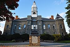
Pulaski County Courthouse
|
||
|
||

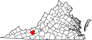
Location within the U.S. state of Virginia
|
||
 Virginia's location within the U.S. |
||
| Country | ||
| State | ||
| Founded | 1839 | |
| Named for | Casimir Pulaski | |
| Seat | Pulaski | |
| Largest town | Pulaski | |
| Area | ||
| • Total | 330 sq mi (900 km2) | |
| • Land | 320 sq mi (800 km2) | |
| • Water | 10 sq mi (30 km2) 3.0% | |
| Population
(2020)
|
||
| • Total | 33,800 |
|
| • Density | 100/sq mi (40/km2) | |
| Time zone | UTC−5 (Eastern) | |
| • Summer (DST) | UTC−4 (EDT) | |
| Congressional district | 9th | |
Pulaski County is a county located in the southwestern part of the U.S. state of Virginia. In 2020, about 33,800 people lived here. The main town and county seat is Pulaski. Pulaski County is also part of the larger Blacksburg-Christiansburg metropolitan area.
Contents
History of Pulaski County
Pulaski County was created on March 30, 1839. It was formed from parts of two other counties, Montgomery and Wythe. This made it the 87th county in Virginia. The county was named after Count Casimir Pulaski. He was a Polish nobleman who came to America and fought alongside George Washington during the American Revolution. He joined the army in 1777 and became a brigadier general. He was a leader of the Continental Army's cavalry (soldiers who fight on horseback). Sadly, he was badly wounded in battle and died on October 11, 1779.
This area is part of the Blue Ridge Mountains. It has rolling hills and was mostly settled by small farmers. Many of these settlers were Scots-Irish and German immigrants, or their children. They moved south from Pennsylvania in the mid to late 1700s. As new settlers arrived, most Native American groups in the area were forced to leave or were killed. These new settlers were mostly "yeomen," meaning they owned their own small farms. They had fewer enslaved people than farmers in other parts of Virginia. However, by 1840, about one-quarter of the people living in Pulaski County were enslaved African Americans. The county had 3,739 people in total. This included 2,768 free white people and 971 Black people. A small number, 17, of the Black residents were free Black people.
Geography and Nature
According to the U.S. Census Bureau, Pulaski County covers a total area of 330 square miles (850 km2). About 320 square miles (830 km2) of this is land, and 10 square miles (26 km2) (3.0%) is water. Pulaski County is one of many counties that are part of the Appalachian Regional Commission. This group works to help the economic development of the Appalachian region.
Pulaski County is home to Claytor Lake State Park. This park is located on Claytor Lake, a large human-made lake. The lake covers 4,500 acres (18 km2) and is 21 miles (34 km) long. It was created on the New River for a hydroelectric project. This project generates electricity using water power. Claytor Lake State Park is on the north side of the lake. It has 497 acres (2.01 km2) with places for camping, cabins, picnic areas, and a swimming beach. There is also a marina for boats. The lake is named after W. Graham Claytor, Sr., who helped supervise the building of the dam and the creation of the lake.
Pulaski County also has other public places where you can go boating. These include Harry DeHaven Park in Allisonia and a site in Dublin. Gatewood Reservoir is another water area, covering 162 acres (0.66 km2). It is owned by the Town of Pulaski and provides water for the town.
Neighboring Areas
Pulaski County shares borders with several other counties and one independent city:
- Bland County – to the northwest
- Giles County – to the north
- Montgomery County – to the northeast
- City of Radford – to the northeast
- Floyd County – to the southeast
- Carroll County – to the south
- Wythe County – to the southwest
Protected Natural Areas
- Jefferson National Forest (part of this large forest is in Pulaski County)
Main Roads and Highways
Major roads that run through Pulaski County include:
 I-81
I-81 US 11
US 11 SR 99
SR 99 SR 100
 SR 114
 SR 9
SR 9
Population and People
| Historical population | |||
|---|---|---|---|
| Census | Pop. | %± | |
| 1840 | 3,739 | — | |
| 1850 | 5,118 | 36.9% | |
| 1860 | 5,416 | 5.8% | |
| 1870 | 6,538 | 20.7% | |
| 1880 | 8,755 | 33.9% | |
| 1890 | 12,790 | 46.1% | |
| 1900 | 14,609 | 14.2% | |
| 1910 | 17,246 | 18.1% | |
| 1920 | 17,111 | −0.8% | |
| 1930 | 20,566 | 20.2% | |
| 1940 | 22,767 | 10.7% | |
| 1950 | 27,758 | 21.9% | |
| 1960 | 27,258 | −1.8% | |
| 1970 | 29,564 | 8.5% | |
| 1980 | 35,229 | 19.2% | |
| 1990 | 34,496 | −2.1% | |
| 2000 | 35,127 | 1.8% | |
| 2010 | 34,872 | −0.7% | |
| 2020 | 33,800 | −3.1% | |
| U.S. Decennial Census 1790–1960 1900–1990 1990–2000 2010 2020 |
|||
The United States Census counts the population every ten years. In 2020, Pulaski County had 33,800 people. This was a slight decrease from 34,872 people in 2010.
Who Lives in Pulaski County?
The 2020 census showed the different groups of people living in Pulaski County:
| Race / Ethnicity | Pop 2010 | Pop 2020 | % 2010 | % 2020 |
|---|---|---|---|---|
| White alone (NH) | 31,972 | 29,716 | 91.68% | 87.92% |
| Black or African American alone (NH) | 1,744 | 1,633 | 5.00% | 4.83% |
| Native American or Alaska Native alone (NH) | 61 | 49 | 0.17% | 0.14% |
| Asian alone (NH) | 179 | 177 | 0.51% | 0.52% |
| Pacific Islander alone (NH) | 7 | 3 | 0.02% | 0.01% |
| Some Other Race alone (NH) | 25 | 100 | 0.07% | 0.30% |
| Mixed Race/Multi-Racial (NH) | 452 | 1,418 | 1.30% | 4.20% |
| Hispanic or Latino (any race) | 432 | 704 | 0.96% | 2.08% |
| Total | 34,872 | 33,800 | 100.00% | 100.00% |
Note: The U.S. Census counts Hispanic/Latino people as an ethnic group. This means they can be of any race.
In 2000, there were 35,127 people living in the county. The average age was 40 years old. About 20.6% of the population was under 18. The median income for a household was $33,873. This means half of the households earned more than this, and half earned less. About 13.1% of the population lived below the poverty line.
Economy and Jobs
The Volvo Trucks North America plant in Pulaski County is a very important part of the local economy. It is the largest Volvo truck plant in the world. In early 2021, the plant started making battery-powered VNR Electric trucks. The facility in Dublin, Virginia employs nearly 3,000 people. They build many different types of heavy-duty trucks there.
Schools and Education
Pulaski County has several schools for students of all ages.
High School and College
- New River Community College
- Southwest Virginia Governor School
- Pulaski County High School
Middle Schools
- Pulaski County Middle School
Elementary Schools
- Pulaski Elementary School
- Dublin Elementary School
- Critzer Elementary School
- Riverlawn Elementary School
- Snowville Elementary School
Communities in Pulaski County
Pulaski County has several towns and other communities.
Towns
Census-Designated Places
These are areas that are like towns but are not officially incorporated as towns.
Other Communities
These are smaller, unincorporated communities.
- Caseknife
- Claytor Lake
- Newbern
- Wurno
- Little Creek
- Delton
- Tinytown
Government and Politics
The Pulaski County Sheriff is Michael W. Worrell. He has worked in law enforcement for over twenty years in Pulaski County. He is a graduate of Pulaski County High School and Radford University.
Voting in Presidential Elections
Pulaski County has often voted for Republican candidates in recent presidential elections.
| Year | Republican | Democratic | Third party | |||
|---|---|---|---|---|---|---|
| No. | % | No. | % | No. | % | |
| 2024 | 12,732 | 71.75% | 4,830 | 27.22% | 182 | 1.03% |
| 2020 | 12,127 | 69.79% | 4,925 | 28.34% | 324 | 1.86% |
| 2016 | 10,322 | 68.06% | 4,172 | 27.51% | 671 | 4.42% |
| 2012 | 8,920 | 60.76% | 5,292 | 36.05% | 468 | 3.19% |
| 2008 | 8,857 | 58.85% | 5,918 | 39.32% | 275 | 1.83% |
| 2004 | 8,769 | 61.53% | 5,310 | 37.26% | 172 | 1.21% |
| 2000 | 7,089 | 55.83% | 5,255 | 41.39% | 353 | 2.78% |
| 1996 | 5,387 | 43.78% | 5,333 | 43.34% | 1,584 | 12.87% |
| 1992 | 6,148 | 43.96% | 5,633 | 40.27% | 2,206 | 15.77% |
| 1988 | 6,844 | 58.40% | 4,686 | 39.99% | 189 | 1.61% |
| 1984 | 8,242 | 64.90% | 4,364 | 34.36% | 93 | 0.73% |
| 1980 | 5,747 | 47.73% | 5,769 | 47.92% | 524 | 4.35% |
| 1976 | 4,764 | 44.84% | 5,546 | 52.20% | 314 | 2.96% |
| 1972 | 6,281 | 72.01% | 2,311 | 26.50% | 130 | 1.49% |
| 1968 | 4,409 | 53.35% | 2,497 | 30.21% | 1,359 | 16.44% |
| 1964 | 3,101 | 46.10% | 3,620 | 53.82% | 5 | 0.07% |
| 1960 | 3,059 | 58.75% | 2,104 | 40.41% | 44 | 0.85% |
| 1956 | 3,517 | 63.05% | 1,994 | 35.75% | 67 | 1.20% |
| 1952 | 2,815 | 62.03% | 1,715 | 37.79% | 8 | 0.18% |
| 1948 | 1,691 | 48.99% | 1,412 | 40.90% | 349 | 10.11% |
| 1944 | 1,302 | 37.65% | 2,155 | 62.32% | 1 | 0.03% |
| 1940 | 1,023 | 31.43% | 2,226 | 68.39% | 6 | 0.18% |
| 1936 | 1,180 | 33.51% | 2,337 | 66.37% | 4 | 0.11% |
| 1932 | 1,109 | 32.11% | 2,314 | 66.99% | 31 | 0.90% |
| 1928 | 1,998 | 52.32% | 1,821 | 47.68% | 0 | 0.00% |
| 1924 | 1,422 | 43.33% | 1,767 | 53.84% | 93 | 2.83% |
| 1920 | 1,710 | 48.43% | 1,814 | 51.37% | 7 | 0.20% |
| 1916 | 721 | 38.68% | 1,057 | 56.71% | 86 | 4.61% |
| 1912 | 196 | 13.27% | 781 | 52.88% | 500 | 33.85% |
State Representatives from Pulaski County
Some notable people who have represented Pulaski County in state government include:
- James A. Walker
- James Hoge Tyler
More to Explore
See also
 In Spanish: Condado de Pulaski (Virginia) para niños
 | Tommie Smith |
 | Simone Manuel |
 | Shani Davis |
 | Simone Biles |
 | Alice Coachman |


