Giles County, Virginia facts for kids
Quick facts for kids
Giles County
|
||
|---|---|---|

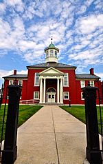
Giles County Courthouse
|
||
|
||

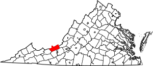
Location within the U.S. state of Virginia
|
||
 Virginia's location within the U.S. |
||
| Country | ||
| State | ||
| Founded | 1806 | |
| Named for | William Branch Giles | |
| Seat | Pearisburg | |
| Largest town | Pearisburg | |
| Area | ||
| • Total | 360 sq mi (900 km2) | |
| • Land | 356 sq mi (920 km2) | |
| • Water | 4.6 sq mi (12 km2) 1.3% | |
| Population
(2020)
|
||
| • Total | 16,787 | |
| • Density | 46.6/sq mi (18.00/km2) | |
| Time zone | UTC−5 (Eastern) | |
| • Summer (DST) | UTC−4 (EDT) | |
| Congressional district | 9th | |
Giles County is a beautiful area in the U.S. state of Virginia. It sits right on the border with West Virginia. In 2020, about 16,787 people lived here. The main town, or county seat, is Pearisburg.
Giles County is part of the larger Blacksburg-Christiansburg area. This means it's connected to a bigger group of towns.
One special thing about Giles County is Mountain Lake. It's one of only two natural freshwater lakes in all of Virginia! Water from this lake flows into Little Stony Creek. This creek then tumbles over a beautiful waterfall called The Cascades before joining the New River.
Contents
History of Giles County
Giles County was created in 1806. It was formed from parts of four other counties: Montgomery, Monroe, Wythe, and Tazewell.
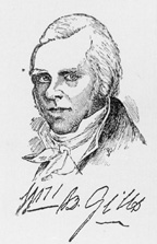
The county is named after a very important person, William Branch Giles. He was born in Amelia County, Virginia, in 1762. William Branch Giles became a lawyer. He was elected to the United States House of Representatives and served there for many years. He also worked in the Virginia General Assembly. Later, in 1827, he became the Governor of Virginia. In total, he served his state and country for about 40 years!
Geography and Nature
According to the U.S. Census Bureau, Giles County covers a total area of about 360 square miles. Most of this, about 356 square miles, is land. The remaining 4.6 square miles, or 1.3%, is water.
Neighboring Counties
Giles County shares its borders with several other counties:
- Summers County, West Virginia – to the north
- Monroe County, West Virginia – to the north
- Craig County – to the east
- Montgomery County – to the southeast
- Pulaski County – to the south
- Bland County – to the west
- Mercer County, West Virginia – to the northwest
Protected Natural Areas
Part of the beautiful Jefferson National Forest is located within Giles County. This forest is a great place for outdoor activities.
Main Roads and Transportation
Several important roads run through Giles County:
 I-73 (future highway)
 US 219
 US 460
 SR 42
SR 42 SR 61
SR 61 SR 100
The Norfolk Southern railroad also has lines running through the county.
Population and People
| Historical population | |||
|---|---|---|---|
| Census | Pop. | %± | |
| 1810 | 3,745 | — | |
| 1820 | 4,521 | 20.7% | |
| 1830 | 5,274 | 16.7% | |
| 1840 | 5,307 | 0.6% | |
| 1850 | 6,570 | 23.8% | |
| 1860 | 6,883 | 4.8% | |
| 1870 | 5,875 | −14.6% | |
| 1880 | 8,794 | 49.7% | |
| 1890 | 9,090 | 3.4% | |
| 1900 | 10,793 | 18.7% | |
| 1910 | 11,623 | 7.7% | |
| 1920 | 11,901 | 2.4% | |
| 1930 | 12,804 | 7.6% | |
| 1940 | 14,635 | 14.3% | |
| 1950 | 18,956 | 29.5% | |
| 1960 | 17,219 | −9.2% | |
| 1970 | 16,741 | −2.8% | |
| 1980 | 17,810 | 6.4% | |
| 1990 | 16,366 | −8.1% | |
| 2000 | 16,657 | 1.8% | |
| 2010 | 17,286 | 3.8% | |
| 2020 | 16,787 | −2.9% | |
| U.S. Decennial Census 1790–1960 1900–1990 1990–2000 2010 2020 |
|||
2020 Census Information
The 2020 census showed that Giles County had a population of 16,787 people. Most residents were White, making up about 93.36% of the population. Other groups included Black or African American, Native American, Asian, and people of mixed races. About 1.45% of the population identified as Hispanic or Latino.
| Race / Ethnicity | Pop 2010 | Pop 2020 | % 2010 | % 2020 |
|---|---|---|---|---|
| White alone (NH) | 16,580 | 15,673 | 95.92% | 93.36% |
| Black or African American alone (NH) | 259 | 238 | 1.50% | 1.42% |
| Native American or Alaska Native alone (NH) | 19 | 28 | 0.11% | 0.17% |
| Asian alone (NH) | 54 | 69 | 0.31% | 0.41% |
| Pacific Islander alone (NH) | 0 | 0 | 0.00% | 0.00% |
| Some Other Race alone (NH) | 7 | 19 | 0.04% | 0.11% |
| Mixed Race/Multi-Racial (NH) | 158 | 516 | 0.91% | 3.07% |
| Hispanic or Latino (any race) | 209 | 244 | 1.21% | 1.45% |
| Total | 17,286 | 16,787 | 100.00% | 100.00% |
Towns and Communities
Giles County has five official towns. Only nine other counties in Virginia have more towns than Giles! About 39% of all people living in Giles County live in one of these five towns. Glen Lyn is the fifth smallest town in Virginia by population.
Main Towns
| Town | Population in 2014 |
|---|---|
| Glen Lyn | 117 |
| Narrows | 1,964 |
| Pearisburg | 2,699 |
| Pembroke | 1,087 |
| Rich Creek | 752 |
Other Communities
Besides the towns, Giles County also has several unincorporated communities. These are smaller places that are not officially towns.
|
|
Schools in Giles County
Giles County has several public schools for students. As of mid-2014, about 2,425 students were enrolled.
- Eastern Elementary/Middle School (in Pembroke)
- Macy McClaugherty Elementary/Middle School (in Pearisburg)
- Narrows Elementary/Middle School (in Narrows)
- Giles High School (in Pearisburg)
- Narrows High School (in Narrows)
- Giles County Technology Center (in Pearisburg)
See also
 In Spanish: Condado de Giles (Virginia) para niños
 | Claudette Colvin |
 | Myrlie Evers-Williams |
 | Alberta Odell Jones |


