Tazewell County, Virginia facts for kids
Quick facts for kids
Tazewell County
|
|||
|---|---|---|---|

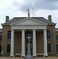
Tazewell County Courthouse
|
|||
|
|||

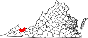
Location within the U.S. state of Virginia
|
|||
 Virginia's location within the U.S. |
|||
| Country | |||
| State | |||
| Founded | December 20, 1799 | ||
| Named for | Henry Tazewell | ||
| Seat | Tazewell | ||
| Largest town | Richlands | ||
| Area | |||
| • Total | 520 sq mi (1,300 km2) | ||
| • Land | 519 sq mi (1,340 km2) | ||
| • Water | 1.1 sq mi (3 km2) 0.2% | ||
| Population
(2020)
|
|||
| • Total | 40,429 | ||
| • Density | 77.7/sq mi (30.02/km2) | ||
| Time zone | UTC−5 (Eastern) | ||
| • Summer (DST) | UTC−4 (EDT) | ||
| Congressional district | 9th | ||
Tazewell County is a county located in the southwestern part of Virginia, a state in the United States. In 2020, about 40,429 people lived here. The main town and county seat is Tazewell.
Tazewell County is part of the Bluefield, WV-VA area. For a long time, its economy depended on mining coal and iron from the Pocahontas Fields.
Contents
History of Tazewell County
Before pioneers arrived, Tazewell County was a hunting ground for Native Americans. You can still find ancient rock carvings, called petroglyphs, near the top of Paintlick Mountain. These are rare in the eastern United States.
In 1771, Thomas and John Witten started the first lasting settlement in Tazewell County. They settled at a place called Crab Orchard.
Tazewell County was officially created on December 20, 1799. Its land came from parts of Wythe and Russell counties. The county was named after Henry Tazewell. He was a U.S. Senator from Virginia, a state lawmaker, and a judge.
The town of Jeffersonville was made the county seat in 1800. Later, on February 29, 1892, Jeffersonville was renamed Tazewell.
A fun fact: The 1994 movie Lassie was filmed here!
Geography of Tazewell County
According to the U.S. Census Bureau, Tazewell County covers about 520 square miles. Most of this (519 square miles) is land, and a small part (1.1 square miles) is water.
Tazewell County has interesting land features because it includes parts of two mountain ranges: the Ridge-and-Valley Appalachians and the Cumberland Plateau. One unique area is Burke's Garden. It's a large, bowl-shaped valley formed by natural erosion.
The county is also where four major river systems begin. These are the Upper Clinch, Middle New, North Fork Holston, and Tug rivers.
Neighboring Counties
- McDowell County, West Virginia (North and West)
- Mercer County, West Virginia (Northeast)
- Buchanan County (Northwest)
- Russell County (West)
- Smyth County (South)
- Bland County (East)
Protected Natural Areas
- Jefferson National Forest (part of it is in Tazewell County)
Main Roads
 US 19
US 19 US 460
 SR 16
SR 16 SR 61
SR 61 SR 67
SR 67 SR 91
SR 91 SR 102
Population of Tazewell County
| Historical population | |||
|---|---|---|---|
| Census | Pop. | %± | |
| 1800 | 2,127 | — | |
| 1810 | 3,007 | 41.4% | |
| 1820 | 3,916 | 30.2% | |
| 1830 | 5,749 | 46.8% | |
| 1840 | 6,290 | 9.4% | |
| 1850 | 9,942 | 58.1% | |
| 1860 | 9,920 | −0.2% | |
| 1870 | 10,791 | 8.8% | |
| 1880 | 12,861 | 19.2% | |
| 1890 | 19,899 | 54.7% | |
| 1900 | 23,384 | 17.5% | |
| 1910 | 24,946 | 6.7% | |
| 1920 | 27,840 | 11.6% | |
| 1930 | 32,477 | 16.7% | |
| 1940 | 41,607 | 28.1% | |
| 1950 | 47,512 | 14.2% | |
| 1960 | 44,791 | −5.7% | |
| 1970 | 39,816 | −11.1% | |
| 1980 | 50,511 | 26.9% | |
| 1990 | 45,960 | −9.0% | |
| 2000 | 44,598 | −3.0% | |
| 2010 | 45,078 | 1.1% | |
| 2020 | 40,429 | −10.3% | |
| 2023 (est.) | 39,120 | −13.2% | |
| U.S. Decennial Census 1790-1960 1900-1990 1990-2000 2010 2020 |
|||
2020 Census Information
The table below shows the different groups of people living in Tazewell County in 2020, based on the U.S. Census.
| Race / Ethnicity | Pop 2010 | Pop 2020 | % 2010 | % 2020 |
|---|---|---|---|---|
| White alone (NH) | 42,692 | 37,336 | 94.71% | 92.35% |
| Black or African American alone (NH) | 1,330 | 961 | 2.95% | 2.38% |
| Native American or Alaska Native alone (NH) | 54 | 56 | 0.12% | 0.14% |
| Asian alone (NH) | 286 | 213 | 0.63% | 0.53% |
| Pacific Islander alone (NH) | 6 | 15 | 0.01% | 0.04% |
| Some Other Race alone (NH) | 23 | 89 | 0.05% | 0.22% |
| Mixed Race/Multi-Racial (NH) | 391 | 1,252 | 0.87% | 3.10% |
| Hispanic or Latino (any race) | 296 | 507 | 0.66% | 1.25% |
| Total | 45,078 | 40,429 | 100.00% | 100.00% |
Note: The U.S. Census counts Hispanic/Latino people as an ethnic group. This table separates them from the racial categories.
Education in Tazewell County
Colleges
Public High Schools
All public schools in Tazewell County are run by the Tazewell County Public Schools system.
Communities in Tazewell County
Towns
Census-Designated Places
These are areas that are like towns but are not officially incorporated.
- Claypool Hill
- Gratton
- Raven (partially in Russell County)
- Springville
Other Communities
Law Enforcement in Tazewell County
| Tazewell County Sheriff's Office | |
|---|---|
| Abbreviation | TCSO |
| Jurisdictional structure | |
| Constituting instrument |
|
| General nature | |
| Operational structure | |
| Headquarters | Tazewell, Virginia |
| Agency executive |
|
| Website | |
| Official Website: http://tazewellcountyva.org/government/sheriffs-office/ | |
The Tazewell County Sheriff's Office (TCSO) is the main law enforcement group in Tazewell County. As of 2022, Sheriff Brian Hieatt leads the agency. Since the Sheriff's Office was created, several officers have bravely lost their lives while serving the community.
See also
 In Spanish: Condado de Tazewell (Virginia) para niños
 | Jessica Watkins |
 | Robert Henry Lawrence Jr. |
 | Mae Jemison |
 | Sian Proctor |
 | Guion Bluford |


