Tug Fork facts for kids
Quick facts for kids Tug Fork |
|
|---|---|

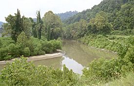
Tug Fork at Williamson, West Virginia
|
|

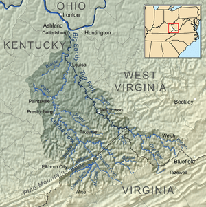
Map of the Big Sandy River watershed, with its Levisa Fork (left) and Tug Fork (right) tributaries shown
|
|
| Country | United States |
| State | Kentucky, Virginia, West Virginia |
| Counties | McDowell WV, Buchanan VA, Pike KY, Mingo WV, Martin KY, Lawrence KY, Wayne WV |
| Physical characteristics | |
| Main source | Big Stone Ridge McDowell County, West Virginia 2,604 ft (794 m) 37°16′38″N 81°26′06″W / 37.27722°N 81.43500°W |
| River mouth | Big Sandy River Louisa, Kentucky 545 ft (166 m) 38°07′05″N 82°36′06″W / 38.11806°N 82.60167°W |
| Length | 159 mi (256 km) |
| Width |
|
| Depth |
|
| Basin features | |
| Tributaries |
|
The Tug Fork is a tributary (a smaller river that flows into a larger one) of the Big Sandy River. It is about 159 miles (256 km) long. This river flows through parts of southwestern West Virginia, southwestern Virginia, and eastern Kentucky in the United States. The Tug Fork is part of a larger water system that eventually reaches the Mississippi River. It connects to the Mississippi River through the Big Sandy River and then the Ohio River.
The river is also sometimes called the Tug Fork River. In 1975, the United States Board on Geographic Names officially decided its name would be "Tug Fork."
Contents
Where the Tug Fork Flows
The Tug Fork starts in the Appalachian Mountains. Its source is in the very southwestern part of West Virginia, in southern McDowell County, close to the Virginia state line.
The river flows in a winding path, generally heading northwest through the mountains. It passes by the town of Welch. For about 4 miles (6 km), it forms a small part of the border between West Virginia (on the northeast side) and Virginia (on the southwest side).
For most of its journey, the Tug Fork creates the border between West Virginia (on the east) and Kentucky (on the west). It continues to flow northwest, passing by Williamson, West Virginia. Finally, it joins with the Levisa Fork at Louisa, Kentucky. When these two rivers meet, they form the larger Big Sandy River.
History of the Tug Fork Valley
The upper part of the Tug Fork flows through a very remote and mountainous area. This river valley, especially between Pike County, Kentucky and Mingo County, West Virginia, was the setting for a famous historical conflict. This was the well-known Hatfield–McCoy feud that happened in the late 1800s.
How the Tug Fork Got Its Name
There are a couple of ideas about how the Tug Fork got its name. A toponymist (someone who studies place names) named George R. Stewart wrote about these ideas.
One story dates back to 1756. A group of Virginians and Cherokees were on a journey. They hunted and ate two buffaloes, hanging their hides on a tree. Later, when they ran out of food, they came back for the hides. They cut the hides into thin strips, which they called "tugs." They then roasted and ate these strips. The story says this event gave the stream its name, "Tug."
Another possible reason for the name might come from the Cherokee language. The Cherokee word "tugulu" means the "forks of a stream." This word is also found in the names of other rivers in areas where the Cherokee people once lived, like the Tugaloo River. So, even if the buffalo hide story is true, the Cherokee word might have helped confirm the name "Tug Fork."
See also
 In Spanish: Río Tug Fork para niños
 | Selma Burke |
 | Pauline Powell Burns |
 | Frederick J. Brown |
 | Robert Blackburn |

