
Lawrence County, Kentucky facts for kids
Quick facts for kids
Lawrence County
|
|
|---|---|

Lawrence County Courthouse in Louisa
|
|

Location within the U.S. state of Kentucky
|
|
 Kentucky's location within the U.S. |
|
| Country | |
| State | |
| Founded | December 14, 1821 |
| Named for | James Lawrence |
| Seat | Louisa |
| Largest city | Louisa |
| Area | |
| • Total | 420 sq mi (1,100 km2) |
| • Land | 416 sq mi (1,080 km2) |
| • Water | 4.5 sq mi (12 km2) 1.1% |
| Population
(2020)
|
|
| • Total | 16,293 |
| • Estimate
(2023)
|
16,000 |
| • Density | 38.8/sq mi (14.98/km2) |
| Time zone | UTC−5 (Eastern) |
| • Summer (DST) | UTC−4 (EDT) |
| Congressional district | 5th |
Lawrence County is a special area in the state of Kentucky, USA. It's called a county. In 2020, about 16,293 people lived here.
The main town and center of the county is Louisa. Lawrence County is named after James Lawrence. It was also helped into being by Isaac Bolt.
Many famous people come from Lawrence County. These include country music star Tyler Childers and former Kentucky Governor Paul E. Patton. Also, a very important judge, Frederick Moore Vinson, who was once the Chief Justice of the United States, was born here.
Contents
History of Lawrence County
Lawrence County was created in 1821. It was formed from parts of two other counties: Floyd County and Greenup County.
The county has had four different courthouses over the years. The very first courthouse was finished in 1823.
Geography of Lawrence County
Lawrence County covers a total area of about 420 square miles. Most of this area, about 416 square miles, is land. The rest, about 4.5 square miles, is water.
The Unique T-Bridge
There is a very interesting bridge in Louisa. It connects Louisa in Kentucky to Fort Gay, West Virginia. This bridge is special because it's a "multi-way T-bridge."
It's a concrete bridge about a quarter-mile long. It crosses over two rivers, the Levisa Fork and the Tug River. These two rivers join to form the Big Sandy River. What makes it unique is that halfway across, the bridge has a right turn! This turn connects traffic to a neighborhood in Louisa called the Point Section.
Yatesville Lake State Park

Yatesville Lake opened in 1992. It is a large lake, covering about 2,300 acres. The U.S. Army Corps of Engineers manages this lake.
Yatesville Lake helps control floods in the area. It also offers many fun things to do outdoors. For example, there's a boat ramp at the Rich Creek area for people who want to go boating.
Neighboring Counties
Lawrence County shares its borders with several other counties:
- Carter County (to the northwest)
- Boyd County (to the north)
- Wayne County, West Virginia (to the east)
- Martin County (to the southeast)
- Johnson County (to the south)
- Morgan County (to the southwest)
- Elliott County (to the west)
People of Lawrence County
| Historical population | |||
|---|---|---|---|
| Census | Pop. | %± | |
| 1830 | 3,900 | — | |
| 1840 | 4,730 | 21.3% | |
| 1850 | 6,281 | 32.8% | |
| 1860 | 7,601 | 21.0% | |
| 1870 | 8,497 | 11.8% | |
| 1880 | 13,262 | 56.1% | |
| 1890 | 17,702 | 33.5% | |
| 1900 | 19,612 | 10.8% | |
| 1910 | 20,067 | 2.3% | |
| 1920 | 17,643 | −12.1% | |
| 1930 | 16,713 | −5.3% | |
| 1940 | 17,275 | 3.4% | |
| 1950 | 14,418 | −16.5% | |
| 1960 | 12,134 | −15.8% | |
| 1970 | 10,726 | −11.6% | |
| 1980 | 14,121 | 31.7% | |
| 1990 | 13,998 | −0.9% | |
| 2000 | 15,569 | 11.2% | |
| 2010 | 15,860 | 1.9% | |
| 2020 | 16,293 | 2.7% | |
| 2023 (est.) | 16,000 | 0.9% | |
| U.S. Decennial Census 1790-1960 1900-1990 1990-2000 2010-2020 |
|||
In 2000, there were about 15,569 people living in Lawrence County. These people made up 5,954 households and 4,477 families.
Most of the people living in the county were White (about 98.93%). A small number were Black or African American, Native American, or Asian. Some people identified with two or more races.
About 35% of the households had children under 18 living with them. Many households (61.3%) were married couples. About 22.4% of households were single people living alone.
The average age of people in Lawrence County was 36 years old. About 25.3% of the population was under 18.
Towns and Communities
Lawrence County has two main cities:
Cities
Other Communities
There are also several smaller, unincorporated communities in Lawrence County. These are places that don't have their own city government.
Images for kids
-
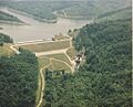
Yatesville Lake, a popular spot for outdoor activities.
See also
 In Spanish: Condado de Lawrence (Kentucky) para niños
