Elliott County, Kentucky facts for kids
Quick facts for kids
Elliott County
|
|
|---|---|

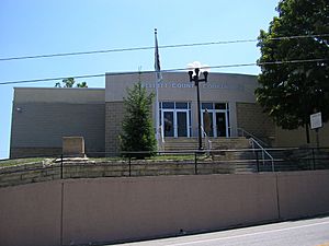
Elliott County courthouse in Sandy Hook
|
|

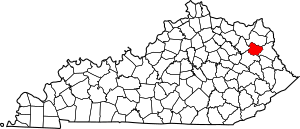
Location within the U.S. state of Kentucky
|
|
 Kentucky's location within the U.S. |
|
| Country | |
| State | |
| Founded | 1869 |
| Named for | John Milton Elliott or John Lyle Elliot |
| Seat | Sandy Hook |
| Largest city | Sandy Hook |
| Area | |
| • Total | 235 sq mi (610 km2) |
| • Land | 234 sq mi (610 km2) |
| • Water | 1.0 sq mi (3 km2) 0.4%% |
| Population
(2020)
|
|
| • Total | 7,354 |
| • Estimate
(2023)
|
7,245 |
| • Density | 31.29/sq mi (12.083/km2) |
| Time zone | UTC−5 (Eastern) |
| • Summer (DST) | UTC−4 (EDT) |
| Congressional district | 5th |
Elliott County is a place in the state of Kentucky, United States. It is known as a county. The main town, or county seat, is Sandy Hook.
Elliott County was created in 1869. It was formed from parts of three other counties: Morgan, Lawrence, and Carter counties. The county is named after John Milton Elliott. He was a judge and a member of the U.S. Congress. Some people think it was named after his father, John Lyle Elliot. He was also a U.S. Congressman. Elliott County is a "dry county." This means that selling alcoholic drinks is not allowed anywhere in the county.
Contents
History of Elliott County
Elliott County was officially started in 1869. The land for the county came from Carter, Lawrence, and Morgan counties. Sadly, a fire happened at the county courthouse in 1957. Many important county records were lost in this fire.
Geography of Elliott County
Elliott County covers a total area of about 235 square miles. Most of this area is land, about 234 square miles. A small part, about 1.0 square mile, is water. This water makes up about 0.4% of the county's total area.
Counties Next to Elliott County
Elliott County shares its borders with four other counties:
- Carter County (to the north)
- Lawrence County (to the east)
- Morgan County (to the south)
- Rowan County (to the west)
People of Elliott County (Demographics)
| Historical population | |||
|---|---|---|---|
| Census | Pop. | %± | |
| 1870 | 4,433 | — | |
| 1880 | 6,567 | 48.1% | |
| 1890 | 9,214 | 40.3% | |
| 1900 | 10,387 | 12.7% | |
| 1910 | 9,814 | −5.5% | |
| 1920 | 8,887 | −9.4% | |
| 1930 | 7,571 | −14.8% | |
| 1940 | 8,713 | 15.1% | |
| 1950 | 7,085 | −18.7% | |
| 1960 | 6,330 | −10.7% | |
| 1970 | 5,933 | −6.3% | |
| 1980 | 6,908 | 16.4% | |
| 1990 | 6,455 | −6.6% | |
| 2000 | 6,748 | 4.5% | |
| 2010 | 7,852 | 16.4% | |
| 2020 | 7,354 | −6.3% | |
| 2023 (est.) | 7,245 | −7.7% | |
| U.S. Decennial Census 1790-1960 1900-1990 1990-2000 2010-2021 |
|||
In 2000, about 6,748 people lived in Elliott County. Most people living here were White, making up about 99% of the population. A very small number of people were from other racial groups. About 0.59% of the people were Hispanic or Latino.
Many people in Elliott County have British ancestry. This means their families originally came from places like England, Scotland, or Wales.
The population in 2000 was spread out by age. About 25% of the people were under 18 years old. About 13% were 65 years or older. The average age in the county was 37 years.
Communities in Elliott County
Elliott County has one official city and many smaller, unincorporated communities.
City
- Sandy Hook (This is the county seat, the main town)
Unincorporated communities
These are smaller towns or areas that are not officially organized as cities.
- Ault
- Bascom
- Beartown
- Bell City
- Bigstone
- Blaines Trace
- Bruin
- Brushy Fork
- Burke
- Clay Fork
- Cliffside
- Culver
- Devil Fork
- Dewdrop
- Dobbins
- Edsel
- Eldridge
- Fannin
- Fannin Valley
- Faye
- Fielden
- Forks of Newcombe
- Gimlet
- Gomez
- Green
- Halcom
- Ibex
- Isonville
- Little Fork
- Little Sandy
- Lytten
- Middle Fork
- Neil Howard's Creek
- Newcombe
- Newfoundland
- Ordinary
- Roscoe
- Shady Grove
- Sarah
- Sideway
- Spanglin
- Stark
- Stephens
- The Ridge
- Wells Creek
- Wyatt
See also
 In Spanish: Condado de Elliott para niños
 | Jessica Watkins |
 | Robert Henry Lawrence Jr. |
 | Mae Jemison |
 | Sian Proctor |
 | Guion Bluford |

