Morgan County, Kentucky facts for kids
Quick facts for kids
Morgan County
|
|
|---|---|

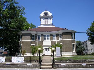
Morgan County courthouse in West Liberty
|
|

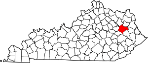
Location within the U.S. state of Kentucky
|
|
 Kentucky's location within the U.S. |
|
| Country | |
| State | |
| Founded | December 7, 1822 |
| Named for | Daniel Morgan |
| Seat | West Liberty |
| Largest city | West Liberty |
| Area | |
| • Total | 384 sq mi (990 km2) |
| • Land | 381 sq mi (990 km2) |
| • Water | 2.7 sq mi (7 km2) 0.7% |
| Population
(2020)
|
|
| • Total | 13,726 |
| • Estimate
(2023)
|
14,283 |
| • Density | 35.74/sq mi (13.801/km2) |
| Time zone | UTC−5 (Eastern) |
| • Summer (DST) | UTC−4 (EDT) |
| Congressional district | 5th |
Morgan County is a county in the state of Kentucky, USA. In 2020, about 13,726 people lived there. The main town and county seat (where the county government is) is West Liberty.
Contents
History
Morgan County was created on December 7, 1822. It was formed from parts of Bath County and Floyd County. The county is named after Daniel Morgan, who was a brave general in the American Revolutionary War.
The first white settler in the area was Daniel Williams. He was a preacher from Virginia. He built the first permanent home a few miles south of where West Liberty is today.
During the American Civil War, many men from Morgan County joined the Confederate army.
On May 29, 1869, a part of Morgan County became part of Menifee County.
Morgan County was hit by a very strong tornado on March 2, 2012. This tornado was an EF3, which is a powerful type of tornado. Six people sadly lost their lives, and many others were hurt. After the tornado, some people moved away, but West Liberty, the county seat, still has a good number of people living there for a small town.
The county had started building a new courthouse in 2011. However, the tornado caused delays. The construction was finished in late 2013.
Geography
Morgan County covers a total area of about 384 square miles (995 square kilometers). Most of this area, about 381 square miles (987 square kilometers), is land. Only a small part, about 2.7 square miles (7 square kilometers), is water.
Adjacent counties
Morgan County shares borders with several other counties:
- Rowan County (to the northwest)
- Elliott County (to the north)
- Lawrence County (to the northeast)
- Johnson County (to the east)
- Magoffin County (to the southeast)
- Wolfe County (to the southwest)
- Menifee County (to the west)
National protected area
A part of the Daniel Boone National Forest is located in Morgan County. This is a large area of protected land.
Population and People
| Historical population | |||
|---|---|---|---|
| Census | Pop. | %± | |
| 1830 | 2,857 | — | |
| 1840 | 4,603 | 61.1% | |
| 1850 | 7,620 | 65.5% | |
| 1860 | 9,237 | 21.2% | |
| 1870 | 5,975 | −35.3% | |
| 1880 | 8,455 | 41.5% | |
| 1890 | 11,249 | 33.0% | |
| 1900 | 12,792 | 13.7% | |
| 1910 | 16,259 | 27.1% | |
| 1920 | 16,518 | 1.6% | |
| 1930 | 15,130 | −8.4% | |
| 1940 | 16,827 | 11.2% | |
| 1950 | 13,624 | −19.0% | |
| 1960 | 11,056 | −18.8% | |
| 1970 | 10,019 | −9.4% | |
| 1980 | 12,103 | 20.8% | |
| 1990 | 11,648 | −3.8% | |
| 2000 | 13,948 | 19.7% | |
| 2010 | 13,923 | −0.2% | |
| 2020 | 13,726 | −1.4% | |
| 2023 (est.) | 14,283 | 2.6% | |
| U.S. Decennial Census 1790-1960 1900-1990 1990-2000 2010-2020 |
|||
In 2000, there were about 13,948 people living in Morgan County. There were 4,752 households, which are groups of people living in one home. About 3,568 of these were families.
The population density was about 37 people per square mile (14 people per square kilometer). This means there were 37 people for every square mile of land.
About 22.4% of the people were under 18 years old. About 10.6% were between 18 and 24 years old. The median age was 36 years. This means half the people were younger than 36, and half were older.
Communities
City
- West Liberty (This is the county seat, the main town where the county government is located.)
Census-designated place
- Ezel (This is a place that the U.S. Census Bureau defines for gathering statistics, but it's not an official city or town.)
Other unincorporated places
These are smaller communities that are not officially organized as cities or towns:
See also
 In Spanish: Condado de Morgan (Kentucky) para niños
 | Leon Lynch |
 | Milton P. Webster |
 | Ferdinand Smith |

