Menifee County, Kentucky facts for kids
Quick facts for kids
Menifee County
|
|
|---|---|

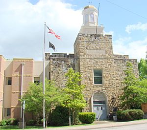
Menifee County courthouse in Frenchburg
|
|

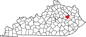
Location within the U.S. state of Kentucky
|
|
 Kentucky's location within the U.S. |
|
| Country | |
| State | |
| Founded | 1869 |
| Named for | Richard H. Menefee |
| Seat | Frenchburg |
| Largest city | Frenchburg |
| Area | |
| • Total | 206 sq mi (530 km2) |
| • Land | 204 sq mi (530 km2) |
| • Water | 2.3 sq mi (6 km2) 1.1% |
| Population
(2020)
|
|
| • Total | 6,113 |
| • Estimate
(2023)
|
6,286 |
| • Density | 29.67/sq mi (11.457/km2) |
| Time zone | UTC−5 (Eastern) |
| • Summer (DST) | UTC−4 (EDT) |
| Congressional district | 6th |
Menifee County is a county located in the state of Kentucky in the United States. In 2020, about 6,113 people lived here. This makes it one of the smallest counties in Kentucky by population.
The main town and county seat is Frenchburg. The county is named after Richard Hickman Menefee. He was a U.S. Congressman. Menifee County is in the foothills of the Cumberland Plateau.
Contents
History of Menifee County
Menifee County was created on May 29, 1869. It was formed from parts of several nearby counties. These included Bath, Montgomery, Morgan, Powell, and Wolfe counties.
On March 2, 2012, a strong tornado hit Menifee County. It also affected other counties nearby. Some people were hurt, and three people sadly died.
Geography and Nature
Menifee County covers about 206 square miles (534 square kilometers). Most of this area, about 204 square miles (528 square kilometers), is land. The rest, about 2.3 square miles (6 square kilometers), is water.
The county has many mountains and thick forests. A large part of the land is inside the Daniel Boone National Forest. Only a small amount of the county's land is used for farming.
Counties Nearby
Menifee County shares borders with these other counties:
- Bath County (to the north)
- Rowan County (to the northeast)
- Morgan County (to the east)
- Wolfe County (to the south)
- Powell County (to the southwest)
- Montgomery County (to the west)
Protected Natural Areas
A part of the Daniel Boone National Forest is located within Menifee County. This forest helps protect nature and offers outdoor activities.
Arts and Culture
Menifee County has a local arts group called the Menifee Community Theatre Group. This group puts on plays and shows. They have produced 17 plays so far.
The group has more than 40 members. Each year, they host a special show during the Menifee Mountain Memories Festival. This show features local stories from the Appalachian region.
Population and People
| Historical population | |||
|---|---|---|---|
| Census | Pop. | %± | |
| 1870 | 1,986 | — | |
| 1880 | 3,755 | 89.1% | |
| 1890 | 4,666 | 24.3% | |
| 1900 | 6,818 | 46.1% | |
| 1910 | 6,153 | −9.8% | |
| 1920 | 5,779 | −6.1% | |
| 1930 | 4,958 | −14.2% | |
| 1940 | 5,691 | 14.8% | |
| 1950 | 4,798 | −15.7% | |
| 1960 | 4,276 | −10.9% | |
| 1970 | 4,050 | −5.3% | |
| 1980 | 5,117 | 26.3% | |
| 1990 | 5,092 | −0.5% | |
| 2000 | 6,556 | 28.8% | |
| 2010 | 6,306 | −3.8% | |
| 2020 | 6,113 | −3.1% | |
| 2023 (est.) | 6,286 | −0.3% | |
| U.S. Decennial Census 1790-1960 1900-1990 1990-2000 2010-2021 |
|||
In 2000, there were 6,556 people living in Menifee County. There were 2,537 households. The average number of people in each household was about 2.49.
The population was spread out by age. About 24.9% of the people were under 18 years old. About 11.8% were 65 years or older. The average age in the county was 36 years.
Towns and Villages
City
- Frenchburg (This is the main town and where the county government is located.)
Unincorporated Communities
These are smaller communities that are not officially cities or towns:
See also
 In Spanish: Condado de Menifee para niños
 | James B. Knighten |
 | Azellia White |
 | Willa Brown |

