Rowan County, Kentucky facts for kids
Quick facts for kids
Rowan County
|
|
|---|---|

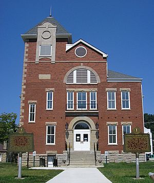
Rowan County Arts Center (formerly Rowan County Courthouse) in Morehead
|
|

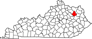
Location within the U.S. state of Kentucky
|
|
 Kentucky's location within the U.S. |
|
| Country | |
| State | |
| Founded | 1856 |
| Named for | John Rowan |
| Seat | Morehead |
| Largest city | Morehead |
| Area | |
| • Total | 286 sq mi (740 km2) |
| • Land | 280 sq mi (700 km2) |
| • Water | 6.5 sq mi (17 km2) 2.3% |
| Population
(2020)
|
|
| • Total | 24,662 |
| • Estimate
(2023)
|
24,409 |
| • Density | 86.23/sq mi (33.29/km2) |
| Time zone | UTC−5 (Eastern) |
| • Summer (DST) | UTC−4 (EDT) |
| Congressional district | 5th |
| Website | www.moreheadrowan.org /rowancounty |
Rowan County is a county located in the northeastern part of Kentucky, a state in the United States. As of 2020, about 24,662 people lived there. Its main town and government center is Morehead.
The county was created in 1856. It was named after John Rowan, who was a politician from Kentucky.
When it comes to selling alcohol, Rowan County is a "moist county." This means that alcohol sales are generally not allowed in most areas. However, the city of Morehead is "wet," which means you can buy packaged alcohol there.
Contents
History
People believe that explorers from Europe first came to Rowan County in 1773. The first settlement was in a town called Farmers, which is west of Morehead. More people moved there quickly because the land was good for farming and there was plenty of water.
Later, in the late 1700s, more settlers came from Virginia. They received land grants, which were gifts of land for helping in the American Revolutionary War. Clearfield was the second settlement. It was started by Dixon Clack in the early 1800s and had the county's first sawmill.
In 1854, Morehead became the third community. Colonel John Hargis bought land and founded the city. He named it after Governor James Morehead.
Rowan County officially started in May 1856. It was formed from parts of Morgan County and Fleming County. Morehead was chosen as the county seat. In 1896, a tax helped Morehead build better roads. By 1920, the road system reached Farmers. In 1961, Rowan County Senior High School was built for students.
Geography
Rowan County covers about 286 square miles. Most of this area, about 280 square miles, is land. The rest, about 6.5 square miles, is water. The highest point in the county is "Limestone Knob." It is about 1,409 feet (429 meters) above sea level.
Neighboring Counties
- Lewis County (north)
- Carter County (northeast)
- Elliott County (east)
- Morgan County (south)
- Menifee County (southwest)
- Bath County (west)
- Fleming County (northwest)
Protected Areas
- Daniel Boone National Forest (part of it is in Rowan County)
Population Facts
| Historical population | |||
|---|---|---|---|
| Census | Pop. | %± | |
| 1860 | 2,282 | — | |
| 1870 | 2,991 | 31.1% | |
| 1880 | 4,420 | 47.8% | |
| 1890 | 6,129 | 38.7% | |
| 1900 | 8,277 | 35.0% | |
| 1910 | 9,438 | 14.0% | |
| 1920 | 9,467 | 0.3% | |
| 1930 | 10,893 | 15.1% | |
| 1940 | 12,734 | 16.9% | |
| 1950 | 12,708 | −0.2% | |
| 1960 | 12,808 | 0.8% | |
| 1970 | 17,010 | 32.8% | |
| 1980 | 19,049 | 12.0% | |
| 1990 | 20,353 | 6.8% | |
| 2000 | 22,094 | 8.6% | |
| 2010 | 23,333 | 5.6% | |
| 2020 | 24,662 | 5.7% | |
| 2023 (est.) | 24,409 | 4.6% | |
| U.S. Decennial Census 1790–1960 1900–1990 1990–2000 2010–2020 |
|||
In 2010, there were 23,333 people living in Rowan County. There were 7,956 households, which are groups of people living together. The county had about 83 people per square mile.
Most people in the county, about 96.1%, were White. About 1.5% were Black or African American. About 0.8% were Asian. About 1.0% were from two or more races. About 1.3% of the people were Hispanic or Latino.
In 7,956 households, about 19.6% had children under 18. About 52.4% were married couples. About 10.2% had a female head of household with no husband.
The average age in Rowan County was 30 years old. A large number of people, about 23.5%, were between 18 and 24. This is mostly because of Morehead State University being in the county.
The average income for a household was $33,081. About 21.3% of the people lived below the poverty line. This included about 20.8% of those under 18.
Media
- WMKY – Morehead State University radio station
- W10BM – A TV channel
- Rowan Review – A local online news source
- The Trail Blazer – Morehead State University's newspaper
- News Center - Morehead State University Television
Communities
Cities
- Lakeview Heights
- Morehead (the main town)
Census-designated place
Other Small Towns
- Clearfield
- Cranston
- Elliottville
- Gates
- Haldeman
- Hayes Crossing
- Hilda
- Paragon
- Pelfrey
- Rodburn
- Sharkey
- Smile
- Triplett
- Wagner Corner
Notable People
- Cora Wilson Stewart (1875–1958) – She was the first woman to lead the Kentucky Education Association. She started "Moonlight School," a program that helped adults learn to read and write at night.
See also
 In Spanish: Condado de Rowan (Kentucky) para niños
 | Mary Eliza Mahoney |
 | Susie King Taylor |
 | Ida Gray |
 | Eliza Ann Grier |


