Cumberland Plateau facts for kids
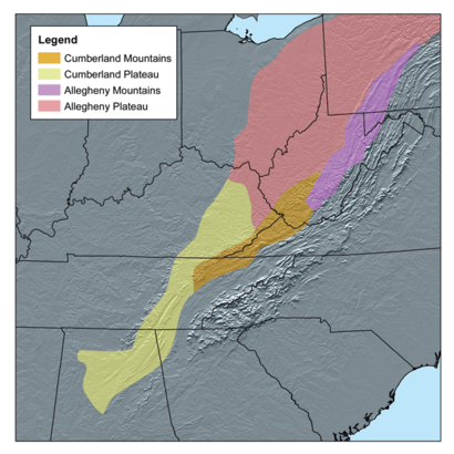
The Cumberland Plateau is a special part of the Appalachian Mountains in the United States. It stretches across parts of eastern Kentucky and Tennessee. It also includes northern Alabama and northwest Georgia. Imagine a huge, flat area that has been carved by rivers and time. This is what we call a "dissected plateau."
The Cumberland Plateau is connected to the Allegheny Plateau further north. These two plateaus share similar features. Two important rivers, the Allegheny River and the Cumberland River, are named after these plateaus. The Cumberland River starts right here in the Cumberland Plateau.
Contents
Exploring the Cumberland Plateau
The Cumberland Plateau is known for its unique landscape. It's like a giant tableland that has been deeply cut by rivers and streams. This creates many hills and valleys. The height difference between the valley floors and the top of the plateau is often about 400 feet (122 meters). You'll often see impressive sandstone cliffs and bluffs here.
Where is the Cumberland Plateau?
In Kentucky, the plateau meets other regions at a place called the Pottsville Escarpment. This area is famous for its stunning cliffs, deep gorges, and hidden rockhouses. You can also find beautiful natural bridges and sparkling waterfalls.
Moving south into Tennessee, the western edge of the Cumberland Plateau borders the Highland Rim. To the east, you'll find Walden Ridge. This ridge continues into Alabama as Sand Mountain. A long, narrow valley called the Sequatchie Valley separates Walden Ridge and Sand Mountain from the main plateau. The Sequatchie River flows through this valley.
The hills in Kentucky's part of the plateau get taller as you go from northwest to southeast. In the western areas, the hills might be around 200 feet (61 meters) high. But near Black Mountain, the highest point in Kentucky, the relief can be more than 2,500 feet (762 meters)!
How the Plateau Was Formed
The Cumberland Plateau is a major part of a larger area called the Appalachian Plateau. It rises about 1,000 feet (305 meters) above the land around it. The rugged landscape of the plateau has led to small, isolated communities. Historically, people here often grew their own food to live, a practice called subsistence agriculture.
The rocks that make up the Cumberland Plateau are very old. They formed during the Mississippian and Pennsylvanian periods of Earth's history. These periods were millions of years ago! The rocks are made of sediments that washed westward from the ancient Appalachian Mountains.
Some layers of rock formed in shallow coastal waters. Other layers, including important bituminous coal seams, formed on land in swampy areas. These layers are mixed with sandstones and sometimes a type of rock called conglomerate. These rocks tell a story of ancient seas and vast swamps that once covered this region.
Nature and Wildlife Conservation
The Cumberland Plateau is home to some of the largest continuous forests in the eastern United States. These forests are a mix of different tree types. You'll find many oak and hickory trees. Pines grow in drier, higher areas. In protected, moist valleys, you can find a rich variety of mesophytic species.
Organizations like the Oak Ridge National Laboratory are working to protect these special forests. Other groups, such as The Nature Conservancy, the Doris Duke Charitable Foundation, and the Natural Resources Defense Council, are also very active in conserving the natural beauty and wildlife of the Cumberland Plateau. Their efforts help keep these important ecosystems healthy for future generations.
See also
 In Spanish: Meseta de Cumberland para niños
- Cumberland Mountains
- Geology of the Appalachians
- List of subranges of the Appalachian Mountains
 | Frances Mary Albrier |
 | Whitney Young |
 | Muhammad Ali |


