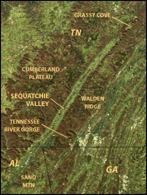
Sequatchie Valley facts for kids
The Sequatchie Valley is a long, narrow valley located in the states of Tennessee and Alabama in the United States. It's part of the larger Cumberland Plateau region, which is itself a part of the Appalachian Mountains. Scientists believe this valley was formed when the land folded upwards, creating a ridge, and then water and weather slowly wore it away over millions of years.
Contents
What is the Sequatchie Valley?
The Sequatchie Valley is a special place known for its unique shape. It stretches for many miles and is quite narrow.
The Sequatchie River
The Sequatchie River flows through the Tennessee part of the valley. It starts in southern Cumberland County, Tennessee, and flows south. The river eventually empties into the Tennessee River close to the Alabama border.
The Valley's Long Journey
Even though the Sequatchie River only flows through the Tennessee section, the valley itself continues into central Alabama. In Alabama, the Tennessee River flows through part of this valley. Further south in Alabama, near Guntersville, Alabama, this same valley is called Browns Valley. It's drained by a stream called Browns Creek. So, while it's all one long valley geologically, the name "Sequatchie Valley" usually refers to the part where the Sequatchie River flows in Tennessee.
How Long and Wide is the Valley?
One cool thing about the Sequatchie Valley is how straight it is. From its very beginning to its end in Browns Valley, it's almost perfectly straight! Geologically, this valley is over 150 miles (240 km) long. The part where the Sequatchie River flows is about 65 miles (105 km) long. The valley is usually about 3 to 5 miles (5 to 8 km) wide.
Mountains and Plateaus Around the Valley
The Sequatchie Valley is surrounded by tall, steep cliffs that are part of the Cumberland Plateau.
East and West Sides
- To the east of the valley, the plateau is narrower. In Tennessee, this eastern side is called Walden Ridge.
- To the west, the plateau is simply known as the Cumberland Plateau. In Bledsoe County, Tennessee, a section of the western cliffs is called Little Mountain. This mountain also marks the Tennessee Valley Divide, which is like a natural line where water flows either to the Tennessee River or away from it.
- In Alabama, the plateau on the east side of the valley is called Sand Mountain. The plateau on the west side is called Gunters Mountain.
The Northern End
At its northern tip, the Sequatchie Valley meets a more mountainous part of the Cumberland Plateau called the Crab Orchard Mountains.
Grassy Cove and Bat Town Cove
Near the Crab Orchard Mountains, a few miles north of the Sequatchie Valley, there's another valley called Grassy Cove. This is a special type of valley called a karst valley. Karst valleys are formed when water slowly dissolves underground rock, creating caves and sinkholes. Over time, these underground changes can cause the surface to collapse, forming a valley. Scientists think that Grassy Cove will eventually grow and become part of the Sequatchie Valley. There's also a smaller karst valley nearby called Bat Town Cove that might also grow and join the Sequatchie Valley in the future.
Towns in the Valley
Many towns are located within the Sequatchie Valley.
Towns in Tennessee
In the Tennessee section of the valley, you can find towns like:
- Pikeville
- Dunlap
- Whitwell
- Jasper
- South Pittsburg (located on the Tennessee River)
Towns in Alabama
In the Alabama part of the geological valley, some towns include:
- Bridgeport
- Scottsboro
- Guntersville
- Blountsville (near the southern end)
 | Precious Adams |
 | Lauren Anderson |
 | Janet Collins |


