Sand Mountain (Alabama) facts for kids
Quick facts for kids Sand Mountain (Alabama) |
|
|---|---|

Sand Mountain in Alabama
|
|
| Geography | |
| Location | Alabama, United States |
| Parent range | Appalachian Mountains |
| Geology | |
| Type of rock | Sandstone |
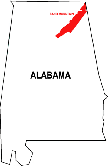
Sand Mountain is a large, flat area of land called a plateau. It's mostly in northeastern Alabama. A small part of it also reaches into northwestern Georgia and southeastern Tennessee. In these states, it's known by names like Raccoon Mountain.
This plateau is made of sandstone. It's part of the southern end of the huge Appalachian Mountains chain. Sand Mountain is actually the biggest plateau in the entire Appalachian chain! It's connected to the Cumberland Plateau, but the Tennessee River separates it.
Sand Mountain sits about 1,500 feet (457 meters) above sea level. The land around it is much lower, about 650 feet (198 meters). This higher elevation means Sand Mountain has the coolest weather in Alabama. The biggest city on Sand Mountain is Albertville. In 2020, about 22,386 people lived there.
Contents
Exploring Sand Mountain's Past
Early History and Native Americans
People have lived in the Sand Mountain area for at least 9,000 years. We know this from old tools and items found nearby at Russell Cave National Monument. Later, Native American groups like the Cherokee and Creek lived in villages close to Sand Mountain.
A very important Cherokee leader named Sequoyah lived near what is now Fort Payne. He created the Cherokee writing system, called a syllabary. This allowed the Cherokee people to read and write in their own language.
First European Visitors
The first Europeans to likely see Sand Mountain were Spanish explorers. Hernando de Soto and his group traveled through the southeastern United States between 1539 and 1543. Historians believe they crossed Sand Mountain on their journey. They were heading south from the Tennessee Valley.
Sand Mountain During the Civil War
During the American Civil War, Sand Mountain saw some action. In September 1863, Union troops tried to cut off Confederate soldiers in Chattanooga. They crossed Sand Mountain but didn't succeed. The two armies later fought at the Battle of Chickamauga.
Many people in northern Alabama, including on Sand Mountain, did not want to leave the United States. They voted against joining the Confederacy. Some even wanted to create a new Union state called Nickajack with parts of Tennessee. Some people on Sand Mountain avoided fighting by working in mines. They mined a material called potassium nitrate to make gunpowder.
Local military groups were formed on Sand Mountain. The "Paint Rock Rifles" joined the Confederate army in 1861. They fought bravely at the Battle of Shiloh. Other groups, like "Gunter's 1st Partisan Ranger Battalion," also formed. They fought in skirmishes along the Tennessee River. Later in the war, a Union regiment was formed in the area. Many men from Sand Mountain, including some who had left the Confederate army, joined it.
A Community in the 20th Century
From 1903 to 1905, a group of about forty Russian Jewish families tried to start a new life on Sand Mountain. They wanted to create a shared farm and factory. However, the area was very isolated from other Jewish communities. The soil was also not ideal for farming. Because of these challenges and disagreements within the group, they left after two years.
Where is Sand Mountain?

Sand Mountain stretches diagonally from the northeast to the southwest. It covers parts of several counties in Alabama: Jackson, DeKalb, Marshall, Etowah, and Blount. It also includes a part of Dade County, Georgia.
The northern part of Sand Mountain is mostly rural. This means it has many farms, including chicken, cow, and potato farms. You can also see large areas of rolling fields and forests. Many small towns and communities are found here.
Life and Culture on Sand Mountain
Sand Mountain is known for being a generally conservative place. People often vote for conservative leaders in elections. The Baptists have the largest number of church members in the area. Many parts of Sand Mountain are "dry," meaning you cannot buy alcoholic drinks there.
Sand Mountain is one of the few places where churches still use Sacred Harp singing. This is a unique style of singing hymns without instruments. Many of the oldest and largest Sacred Harp singing events happen here.
A book called Salvation on Sand Mountain was written in 1996. It talked about snake handling in some churches on Sand Mountain. However, many people who live on Sand Mountain say the book mostly described events in Scottsboro, which is in the valley next to the mountain.
Sand Mountain's Weather
Sand Mountain is in the southern United States. This means it has long, hot, and humid summers. The winters are short and mild compared to many other parts of the country. Snow is very rare here.
Because of its higher elevation, Sand Mountain is cooler than other parts of Alabama. Between 60 and 90 days each year have temperatures over 86°F (30°C). These hot days, combined with high humidity, make summers feel very warm. The average daytime temperature is above 70°F (21°C) for at least five months of the year.
Sand Mountain also gets a lot of rain. It receives more rainfall than almost anywhere else in the South, except for the Gulf Coast area. Some parts get over 66 inches (168 cm) of rain per year.
Here's a general idea of the climate on Sand Mountain, based on data from Ider, Alabama:
| Climate data for Sand Mountain, Alabama (spec. Ider, Ala.) | |||||||||||||
|---|---|---|---|---|---|---|---|---|---|---|---|---|---|
| Month | Jan | Feb | Mar | Apr | May | Jun | Jul | Aug | Sep | Oct | Nov | Dec | Year |
| Mean daily maximum °F (°C) | 48 (9) |
53 (12) |
61 (16) |
70 (21) |
77 (25) |
84 (29) |
88 (31) |
87 (31) |
82 (28) |
72 (22) |
61 (16) |
51 (11) |
70 (21) |
| Mean daily minimum °F (°C) | 26 (−3) |
28 (−2) |
35 (2) |
42 (6) |
52 (11) |
60 (16) |
65 (18) |
64 (18) |
57 (14) |
44 (7) |
36 (2) |
29 (−2) |
45 (7) |
| Average precipitation inches (mm) | 6.06 (154) |
5.62 (143) |
6.57 (167) |
4.73 (120) |
4.70 (119) |
4.33 (110) |
5.18 (132) |
3.49 (89) |
4.27 (108) |
3.29 (84) |
5.00 (127) |
5.12 (130) |
58.36 (1,482) |
| Source: Weather.com | |||||||||||||
The Soil of Sand Mountain
The soil on Sand Mountain is usually about 2 to 4 feet (0.6 to 1.2 meters) deep. Below that, you hit solid sandstone bedrock. The soil is mostly a type called loam, which is a mix of sand and silt. It's very acidic, meaning it has a low pH level. The soil is also considered "well-drained," so water flows through it easily.
Towns and Communities on Sand Mountain
Many towns and communities are located on Sand Mountain.
Jackson County
- Browntown
- Bryant
- Central
- Davistown
- Dutton
- Eliza
- Fabius
- Fair View
- Flat Rock
- Higdon
- Liberty Hill
- Macedonia
- Overlook
- Pisgah
- Rosalie
- Section
- Shrader
DeKalb County
- Blake
- Brooks Crossroads
- Cartersville
- Council Bluff
- Crossville
- Dawson
- Elliott Crossroads
- Five Forks
- Fort Payne
- Fyffe
- Geraldine
- Grove Oak
- Guest
- Henagar
- High Point
- Horton shanna
- Ider
- Kilpatrick
- Lakeview
- Lathamville
- Liberty
- Old Blevins Mill
- Plainview
- Powell
- Rainsville
- Shiloh
- Skaggs Corner
- Sylvania
- Ten Broeck
- Townson Crossroads
- Whiton
Marshall County
- Albertville
- Asbury
- Boaz (partially located in Etowah County)
- Douglas
- Guntersville (only partially located on Sand Mountain)
Etowah County
Blount County
- Oneonta (only partially located on Sand Mountain)
- Snead
- Susan Moore
 | Anna J. Cooper |
 | Mary McLeod Bethune |
 | Lillie Mae Bradford |

