Dade County, Georgia facts for kids
Quick facts for kids
Dade County
|
|||
|---|---|---|---|

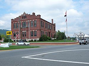
Dade County Courthouse in Trenton
|
|||
|
|||

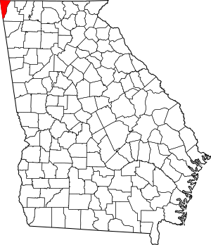
Location within the U.S. state of Georgia
|
|||
 Georgia's location within the U.S. |
|||
| Country | |||
| State | |||
| Founded | 1837 | ||
| Named for | Francis L. Dade | ||
| Seat | Trenton | ||
| Largest city | Trenton | ||
| Area | |||
| • Total | 174 sq mi (450 km2) | ||
| • Land | 174 sq mi (450 km2) | ||
| • Water | 0.2 sq mi (0.5 km2) 0.1%% | ||
| Population
(2020)
|
|||
| • Total | 16,251 | ||
| • Estimate
(2023)
|
16,165 |
||
| • Density | 93.40/sq mi (36.06/km2) | ||
| Time zone | UTC−5 (Eastern) | ||
| • Summer (DST) | UTC−4 (EDT) | ||
| Congressional district | 14th | ||
Dade County is a special place in the U.S. state of Georgia. It's located in the very northwest corner of the state. In fact, its northwest tip is the westernmost point in all of Georgia!
As of 2020, about 16,251 people live here. The main town and only official city is Trenton. Dade County is also part of the larger Chattanooga area, which includes parts of Tennessee and Georgia.
Did you know that in 1860, people in Dade County voted to leave both Georgia and the United States? No government outside the county ever agreed that this was legal. Then, in 1945, the county officially "rejoined" Georgia and the U.S. in a special ceremony.
Contents
History of Dade County
Dade County was created in 1837. It was named after Major Francis Langhorne Dade. He was a brave soldier who died in a battle with Seminole Native Americans in 1835.
The first European settlers in Dade County got their land through the Georgia Land Lotteries. These lotteries helped people settle the land after the Cherokee people were forced to leave their homes. Many early settlers worked in coal mines. These mines helped the nearby city of Chattanooga, Tennessee grow.
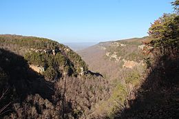
For a long time, Dade County was hard to reach. Mountains and rivers surrounded it, making it quite isolated. For its first 100 years, there was no direct road connecting it to the rest of Georgia. People had to travel through Alabama or Tennessee to get there! This changed in 1939 when Cloudland Canyon State Park was created. Georgia then built Highway 136 to connect the park to other roads. The Civilian Conservation Corps, a group that helped people find jobs during the Great Depression, built many of the park's roads and buildings.
The "Independent State of Dade"
Before the American Civil War, some people in Dade County wanted to leave the United States. In 1860, they were very eager to secede. Legend says that the people of Dade County were so impatient that they declared their own independence from both Georgia and the U.S.
On July 4, 1945, a special message from President Harry S. Truman was read at a celebration. This event marked the county's symbolic "rejoining" of the Union. Historians say that Dade County's individual secession and rejoining were mostly symbolic. They didn't have any legal power. Officially, Dade County left the Union with the rest of Georgia in 1861 and rejoined with the state in 1870.
Famous People and Colleges
A well-known writer named George Washington Harris is buried in Trenton. He wrote funny stories about the South and influenced famous authors like Mark Twain. His grave wasn't marked until 2008.
In 1964, Covenant College moved its campus to Lookout Mountain in Dade County. The college started in California in 1955. After growing in St. Louis, Missouri, it needed more space and chose Dade County for its new home.
Geography
Dade County covers about 174 square miles (450 square kilometers). Almost all of this area is land, with only a tiny bit of water.
The county is in the southern part of the Appalachian Mountains, just like most of northwest Georgia. Most of its rivers and streams flow into the Tennessee River.
Major Highways
Here are some of the main roads that go through Dade County:

 I-24 / SR 409
 I-59 / SR 406
 US 11 / SR 58
 SR 136
 SR 157
 SR 189
 SR 299
 SR 301
Neighboring Counties
Dade County shares borders with counties in Tennessee and Alabama:
- Marion County, Tennessee (north)
- Hamilton County, Tennessee (northeast)
- Walker County (southeast)
- DeKalb County, Alabama (southwest)
- Jackson County, Alabama (west)
Protected Areas
These are special natural or historical places in Dade County:
People in Dade County (Demographics)
| Historical population | |||
|---|---|---|---|
| Census | Pop. | %± | |
| 1840 | 1,364 | — | |
| 1850 | 2,680 | 96.5% | |
| 1860 | 3,069 | 14.5% | |
| 1870 | 3,033 | −1.2% | |
| 1880 | 4,702 | 55.0% | |
| 1890 | 5,707 | 21.4% | |
| 1900 | 4,578 | −19.8% | |
| 1910 | 4,139 | −9.6% | |
| 1920 | 3,918 | −5.3% | |
| 1930 | 4,146 | 5.8% | |
| 1940 | 5,894 | 42.2% | |
| 1950 | 7,364 | 24.9% | |
| 1960 | 8,666 | 17.7% | |
| 1970 | 9,910 | 14.4% | |
| 1980 | 12,318 | 24.3% | |
| 1990 | 13,147 | 6.7% | |
| 2000 | 15,154 | 15.3% | |
| 2010 | 16,633 | 9.8% | |
| 2020 | 16,251 | −2.3% | |
| 2023 (est.) | 16,165 | −2.8% | |
| U.S. Decennial Census 1790–1880 1890-1910 1920-1930 1930-1940 1940-1950 1960-1980 1980-2000 2010 2020 |
|||
2020 Census Information
The 2020 United States census counted 16,251 people living in Dade County. There were 6,195 households and 4,539 families.
| Race / Ethnicity (NH = Non-Hispanic) | Pop 2000 | Pop 2010 | Pop 2020 | % 2000 | % 2010 | % 2020 |
|---|---|---|---|---|---|---|
| White alone (NH) | 14,685 | 15,796 | 14,786 | 96.91% | 94.97% | 90.99% |
| Black or African American alone (NH) | 96 | 142 | 141 | 0.63% | 0.85% | 0.87% |
| Native American or Alaska Native alone (NH) | 67 | 65 | 68 | 0.44% | 0.39% | 0.42% |
| Asian alone (NH) | 56 | 114 | 129 | 0.37% | 0.69% | 0.79% |
| Pacific Islander alone (NH) | 4 | 5 | 5 | 0.03% | 0.03% | 0.03% |
| Other race alone (NH) | 1 | 24 | 31 | 0.01% | 0.14% | 0.19% |
| Mixed race or Multiracial (NH) | 108 | 195 | 727 | 0.71% | 1.17% | 4.47% |
| Hispanic or Latino (any race) | 137 | 292 | 364 | 0.90% | 1.76% | 2.24% |
| Total | 15,154 | 16,633 | 16,251 | 100.00% | 100.00% | 100.00% |
2010 Census Information
In 2010, there were 16,633 people living in Dade County. Most people were white (96%). About 1.8% of the population was of Hispanic or Latino origin.
The average age of people in Dade County was 39 years old. The median income for a family was about $48,881 per year. About 15.5% of the population lived below the poverty line.
Education
Water Supply in Georgia
Dade County is located near Nickajack Lake, which is on the Tennessee River. This lake was created by the Tennessee Valley Authority, a government agency.
The city of Atlanta, Georgia wanted to use water from Nickajack Lake. They also get water from other lakes like Lake Lanier and Lake Allatoona. In 2008, some Georgia lawmakers wanted to change the border between Tennessee and Georgia. They believed the original survey from 1818 was wrong and that Georgia's northern border should extend to the Tennessee River. If the border changed, Georgia would have rights to the water. However, they were not successful in changing the border.
Communities in Dade County
Cities
Census-designated places
These are areas that are like towns but are not officially incorporated as cities.
- New England
- West Brow
- Wildwood
Other Unincorporated Communities
These are smaller communities that are not officially cities or census-designated places.
- Head River
- Hooker
- Morganville
- New Home
- New Salem
- Rising Fawn
- Davis
Ghost Towns
These are towns that used to exist but are now abandoned.
- Cole City
- Tatum
Notable People from Dade County
- The Forester Sisters - A popular country music group.
See also
 In Spanish: Condado de Dade (Georgia) para niños
 | Tommie Smith |
 | Simone Manuel |
 | Shani Davis |
 | Simone Biles |
 | Alice Coachman |


