
Miami-Dade County, Florida facts for kids
Quick facts for kids
Miami-Dade County
|
|||||
|---|---|---|---|---|---|
       Left to right from top down: Downtown Miami Skyline; a lifeguard station on South Beach; South of 15th Street on Ocean Drive (South Beach); Venetian Pool in Coral Gables; Anhinga Trail boardwalk in Everglades National Park; Kaseya Center on Biscayne Boulevard; and an aquatic reef in Biscayne National Park
|
|||||
|
|||||
| Nicknames:
"Dade County", "Dade", "Metro-Dade", "Greater Miami"
|
|||||
| Motto(s):
Delivering Excellence Every Day
|
|||||
 |
|||||

Miami-Dade County
Location in the United States
|
|||||
| Country | |||||
| State | |||||
| Region | South Florida | ||||
| Metro area | Miami | ||||
| Founded | February 4, 1836 | ||||
| Named for | Francis L. Dade and Miami, derived from the Miami River, and ultimately derived from Mayaimi | ||||
| County seat and largest city |
Miami | ||||
| Incorporated municipalities | 34 | ||||
| Government | |||||
| • Type | Two-tier federation | ||||
| • Body | Miami-Dade Board of County Commissioners | ||||
| Area | |||||
| • Total | 2,431.178 sq mi (6,296.72 km2) | ||||
| • Land | 1,898.753 sq mi (4,917.75 km2) | ||||
| • Water | 532.425 sq mi (1,378.97 km2) 21.9% | ||||
| Highest elevation
(Miami Rock Ridge)
|
20-25 ft (6–8 m) | ||||
| Lowest elevation | 0 ft (0 m) | ||||
| Population
(2020)
|
|||||
| • Total | 2,701,767 | ||||
| • Estimate
(2023)
|
2,686,867 |
||||
| • Rank | 7th in the United States 1st in Florida |
||||
| • Density | 1,111.2995/sq mi (429.07515/km2) | ||||
| Demonym(s) | Miamian | ||||
| GDP | |||||
| • Total | $219.476 billion (2022) | ||||
| Time zone | UTC−5 (Eastern Time Zone) | ||||
| • Summer (DST) | UTC−4 (Eastern Daylight Time) | ||||
| ZIP Codes |
33002, 33010–33018, 33030–33035, 33039, 33054, 33056, 33090, 33092, 33101–33102, 33106, 33109, 33111–33112, 33114, 33116, 33119, 33122, 33124–33147, 33149–33158, 33160–33170, 33172–33199, 33206, 33222, 33231, 33233–33234, 33238–33239, 33242–33243, 33245, 33247, 33255–33257, 33261, 33265–33266, 33269, 33280, 33283, 33296, 33299
|
||||
| Area codes | 305, 786, 645 | ||||
| FIPS code | 12086 | ||||
| GNIS feature ID | 295755 | ||||


Miami-Dade County is a large area in the southeastern part of Florida. It's home to over 2.7 million people, making it the most populated county in Florida. It's also the seventh most populated county in the entire United States. The county seat, or main city, is Miami. Miami is a very important city, and the larger Miami area is one of the biggest in the world.
Miami-Dade County is a major economic hub. It has the largest economy of any county in Florida. The county is home to the Port of Miami, which is the world's busiest passenger port. It also has Miami International Airport, a huge airport for international travelers and cargo. The county is nearly 2,000 square miles big, which is larger than two U.S. states: Delaware and Rhode Island.
You'll find several universities here, like Florida International University, one of the biggest public universities in the country. The University of Miami is also here, a private research university known for its strong programs.
Miami-Dade County has a large Hispanic population. It has 34 cities and many other communities. The northern and eastern parts are very urban with tall buildings along the coast. This includes Downtown Miami. The southern part of the county, like the Redland and Homestead areas, is more focused on farming.
The county also includes parts of two national parks: Everglades National Park to the west and Biscayne National Park to the east.
Contents
History of Miami-Dade County
This section explores the past of Miami-Dade County, from its first inhabitants to major events.
Early Native People
The first people lived in the Miami area about 12,000 years ago. They settled along the Miami River. The main villages were on the north side of the river.
When Europeans first arrived, the Tequesta people lived here. They controlled much of southeastern Florida. The Tequesta were hunters and gatherers. They did not farm. They had unique burial customs, keeping larger bones in a box for the village to see. The Miami Circle is a famous site believed to have been made by the Tequesta.
European Explorers and Settlers Arrive
Juan Ponce de León was the first European to visit the area in 1513. He sailed into Biscayne Bay. He recorded the name Chequescha, which was an early name for Miami. Later, in 1566, Pedro Menéndez de Avilés and his men were the first to land. They visited the Tequesta village.
A Spanish mission was built in 1567, but it didn't last long. After the Spanish left, European diseases like smallpox greatly affected the Tequesta. By 1711, most of the Tequesta had died.
The first permanent European settlers came in the early 1800s. People from the Bahamas came looking for treasure from shipwrecks. Some accepted Spanish land offers along the Miami River. Around the same time, Seminole Indians and runaway slaves also arrived.
The Second Seminole War (1835-1842) greatly impacted the area. Most non-Native residents were soldiers at Fort Dallas. This war caused many people to leave Miami.
After the war, William English restarted a farm on the Miami River. He created the "Village of Miami" and sold land plots. In 1844, Miami became the county seat. By 1850, there were 96 residents. The Third Seminole War also slowed settlement, but it was less destructive.
How Miami-Dade County Was Formed

Dade County was officially created on February 4, 1836. It was named after Major Francis L. Dade. He was a soldier killed in 1835 during the Second Seminole War. The place where he died is now called the Dade Battlefield.
The county was almost named "Pinckney County." However, when news of the Dade Massacre reached Tallahassee, they decided to name it after Major Dade instead.
When it was first created, Dade County was much larger. It included land that is now Palm Beach and Broward counties. It also included parts of the Florida Keys. The county seat moved several times before settling in Miami in 1899. In 1909 and 1915, parts of Dade County were used to create Palm Beach and Broward counties. The county's borders haven't changed much since 1915.
Hurricane Andrew's Impact
Hurricane Andrew hit Miami on August 24, 1992. It was one of the most expensive natural disasters in U.S. history at the time. The hurricane caused over $25 billion in damages in the county. Areas like Homestead, Kendall, and Cutler Bay were hit the hardest. It took many years for these areas to recover.
Changing the County's Name
Miami-Dade County tried to change its name five times between 1958 and 1990. Voters rejected every proposal. For example, in 1990, only 13% of voters wanted to change the name to "Metropolitan Miami–Dade County."
However, on November 13, 1997, voters finally approved a name change. The county's name changed from "Dade County" to "Miami-Dade County." This was done to recognize Miami's international fame. Miami-Dade County became the only county in the United States with a hyphenated name.
Geography and Natural Areas
Miami-Dade County covers a large area in South Florida. It has a unique landscape with both urban areas and natural parks.

The county covers about 2,431 square miles. About 1,898 square miles are land, and 533 square miles are water. Much of the water is in Biscayne Bay and the Atlantic Ocean.
Miami-Dade County is very flat, only about 6 feet above sea level. Its land is geologically new. The eastern part is made of Oolite limestone. The western part is mostly Bryozoa. This area was one of the last parts of Florida to get its plants and animals.
Many barrier islands separate Biscayne Bay from the Atlantic Ocean. The city of Miami Beach, known for South Beach and its Art Deco buildings, is on these islands. The Florida Keys are also nearby, extending to the south. Miami is about 68 miles from West Palm Beach and 30 miles from Fort Lauderdale.
Neighboring Counties
- Broward County – to the north
- Monroe County – to the southwest
- Collier County – to the northwest
Protected Natural Areas
Miami-Dade County is home to parts of important national parks:
People and Demographics
Miami-Dade County is a very diverse place with people from many different backgrounds.


As of 2020, about 68.7% of the population is Hispanic or Latino. About 14% are Black or African American (non-Hispanic). And 13.4% are White (non-Hispanic).
Many people in Miami-Dade County were born outside the United States. In 2020, about 54% of the population was foreign-born. The largest group of foreign-born residents came from Cuba. Other large groups came from Venezuela, Colombia, Haiti, and Nicaragua.
Languages Spoken
In 2010, about 28.1% of people in Miami-Dade County spoke only English at home. A large majority, 63.8%, spoke Spanish. Other languages spoken include French Creole (like Haitian Creole), French, and Portuguese.
Religious Groups
Miami-Dade County has many different religious communities. The largest group is Roman Catholics. There are also many non-denominational churches and Baptist congregations. Other groups include Seventh-day Adventists, Pentecostals, Mormons, and Episcopalians.
The county also has a significant Muslim population and smaller communities of Hindus and Buddhists. Miami-Dade County has Florida's third-largest Jewish population.
Economy and Jobs
Miami-Dade County is a hub for many businesses and industries.


Many big companies have their main offices in Miami-Dade County. These include Brightstar Corporation, Burger King, Norwegian Cruise Line, Lennar, and Ryder. Several cargo airlines like Centurion Air Cargo and Florida West International Airways are based at Miami International Airport.
Hewlett Packard has its main Latin America offices here. Other companies like AstraZeneca and Goya Foods also have offices in the county.
Top Employers
Many people work for large organizations in Miami-Dade County. Here are some of the biggest private employers:
- University of Miami
- Baptist Health South Florida
- American Airlines
- Carnival Cruise Line
- Nicklaus Children's Hospital
- Mount Sinai Medical Center
- Florida Power & Light
- Royal Caribbean International
- Wells Fargo
- Bank of America
Agriculture in Miami-Dade
Farming is an important part of the economy in the southern areas of Miami-Dade County.
A lot of the state's summer okra is grown here. Farmers use special methods to grow crops and manage pests. For example, they deal with insects like melon thrips and aphids. Scientists from the University of Florida help farmers with tips on managing diseases and weeds.
Miami-Dade County has the largest greenhousing and nursery industry in Florida. This means many plants are grown in special buildings or outdoor areas for sale. However, the county produces very little livestock.
Public Services
Miami-Dade County provides many important services to its residents, from safety to libraries.
Fire and Rescue Services

The Miami-Dade Fire Rescue Department helps keep people safe. They provide fire protection and emergency medical services. They serve 29 cities and all other areas of the county from 60 fire stations. They also protect Miami International Airport and other smaller airports.
This department also includes Urban Search and Rescue Florida Task Force 1. This team helps in big emergencies and disasters.
Police Department

The Miami-Dade Police Department is the largest police department in Florida. It has 4,700 employees. They patrol the unincorporated areas of the county. They also work with other city police departments, like the City of Miami Police Department. Their main office is in Doral, Florida.
Water and Sewer Services
The Miami-Dade Water and Sewer Department (MDWASD) is one of the biggest public utilities in the U.S. They provide water and sewer services to over 2.4 million customers. Every day, they get about 330 million gallons of water from the Biscayne Aquifer for people to use.
Aviation Department
The Miami-Dade Aviation Department (MDAD) manages several airports. These include Miami International Airport, Miami Executive Airport, and Opa-locka Executive Airport.
Public Libraries


The Miami-Dade Public Library System started in 1894 with a reading room in Lemon City. In 1942, neighborhood libraries joined to form a single system. In 1971, the City of Miami transferred its library system to Miami-Dade County.
In 1972, voters approved funds to build new libraries. Between 1976 and 1990, 14 new libraries opened. Hurricane Andrew in 1992 damaged many libraries in the southern part of the county. After 2001, more funds were approved, leading to 18 new libraries opening by 2011.
Today, the Miami-Dade Public Library System serves most of the county. It has 49 branches, two bookmobiles, and one technobus.
Education in Miami-Dade County
Miami-Dade County offers many educational opportunities, from public schools to large universities.


Colleges and Universities
- The University of Miami in Coral Gables is a top research university.
- Florida International University (FIU) in University Park is one of the largest universities in the U.S. by student numbers.
- Miami Dade College in Miami has one of the largest undergraduate enrollments of any college in the U.S., with over 100,000 students.
Other colleges and universities in the county include:
- Barry University (private/Catholic)
- Nova Southeastern University (private)
- Florida National University (private)
- Florida Memorial University (private/historically black)
- St. Thomas University (private/Catholic)
- Johnson & Wales University (private)
- Carlos Albizu University (private)
- Miami International University of Art & Design (private)
- Yeshiva V'Kollel Beis Moshe Chaim (private/Jewish)
- Miami Ad School (private)
- Southeastern College (private)
K-12 Schools
Each county in Florida has its own school district. Miami-Dade County Public Schools is the fourth-largest public school district in the nation. It serves almost 360,000 students. The district is managed by an elected School Board and a Superintendent.
Miami-Dade County has many public and private schools for students from kindergarten to 12th grade.
Places to Visit
Miami-Dade County has many interesting museums, cultural spots, and attractions.


Museums and Gardens
- Bass Museum of Art, Miami Beach
- Coral Castle, Homestead Miami
- Fairchild Tropical Botanic Garden, Coral Gables
- Frost Art Museum, at Florida International University
- Gold Coast Railroad Museum, Miami
- HistoryMiami, Downtown Miami
- Holocaust Memorial, Miami Beach
- Jewish Museum of Florida, Miami Beach
- Lowe Art Museum, at the University of Miami
- Miami Children's Museum, Miami
- Museum of Contemporary Art, North Miami
- Pérez Art Museum Miami, Miami
- Phillip and Patricia Frost Museum of Science, Miami
- Vizcaya Museum and Gardens, Miami
- Wings Over Miami Museum, Miami
- Wolfsonian, at Florida International University
Culture and Wildlife Attractions


- Adrienne Arsht Center for the Performing Arts, Downtown Miami
- Ancient Spanish Monastery, North Miami Beach
- Bayside Marketplace, Downtown Miami
- Jungle Island, Miami
- Miami Seaquarium, Miami
- Monkey Jungle, Miami
- Vizcaya Museum and Gardens, Miami
- Zoo Miami, Miami
Other Fun Places to Explore

- South Beach
- Ocean Drive
- Calle Ocho
- Lincoln Road
- Downtown Miami
- Bal Harbour Shops
- Dolphin Mall
- Aventura Mall
- Biltmore Hotel
- Freedom Tower
- Miami Art Deco District
- Miami Design District
- Little Havana
- Star Island
- Brickell
- Wynwood Art District
Parks to Enjoy
- Tropical Park
- Bayfront Park
- The Barnacle Historic State Park
- Museum Park
- Crandon Park
- Bill Baggs Cape Florida State Park
- Oleta River State Park
- Everglades National Park
- Biscayne National Park
Sports Venues

.jpg)
Miami-Dade County has many sports arenas and stadiums:
- Hard Rock Stadium – Home to the Miami Dolphins (NFL football) and Miami Hurricanes (college football). It also hosts the Miami Open (tennis) and Miami Grand Prix (Formula 1 racing).
- LoanDepot Park – Home to the Miami Marlins (MLB baseball).
- Kaseya Center – Home to the Miami Heat (NBA basketball).
- Riccardo Silva Stadium – Home to the FIU Panthers (college football) and Miami FC (soccer).
- Homestead-Miami Speedway – Hosts NASCAR and IndyCar auto racing.
Transportation
Getting around Miami-Dade County is possible through various ways, including airports, public transit, and major roads.
Airports in the County

Miami International Airport (MIA) is the main international airport for the Miami area. It's one of the busiest international airports in the world, serving over 35 million passengers each year. It's a major hub for American Airlines. MIA is the third largest international entry point in the U.S. for air passengers. It has flights to over 70 international cities.
Other airports in Miami-Dade County include:
- Miami-Opa Locka Executive Airport – A civil-military airport.
- Miami Seaplane Base – A public seaplane base near downtown Miami.
- Miami Executive Airport – A public airport in southwest Miami-Dade County.
- Homestead General Aviation Airport – A public airport near Homestead.
- Homestead Air Reserve Base – A military base near Homestead.
- Dade-Collier Training and Transition Airport – An airport located in the Florida Everglades, owned by Miami-Dade County.
Public Transportation
Miami-Dade Transit (MDT) runs the public transportation system. It's the largest system in Florida. MDT operates:
- Metrorail: A heavy rail train system.
- Metromover: An elevated train that serves Downtown Miami, Brickell, and the Arts & Entertainment District.
- Metrobus: A county-wide bus system.
Many cities in the county also have their own free local trolleys. These trolleys connect with the MDT network. For example, Aventura, Coral Gables, and Miami Beach have trolley services. The Homestead trolley even offers seasonal service to Biscayne National Park and Everglades National Park.
MDT also works with transit systems in Broward County and Monroe County to provide connecting bus services.
Other train services include Tri-Rail, a commuter rail that connects Miami-Dade with Broward and Palm Beach counties. Amtrak and Brightline offer intercity rail services.
The Miami Intermodal Center (MIC) is a large transportation hub near Miami International Airport. It connects the airport to all these different public transportation options.
Major Roads and Highways
Miami-Dade County has many important expressways:
 I-75
I-75 I-95
I-95
 I-195 / SR 112
 I-395 / SR 836
 US 1
US 1 US 27
US 27 US 41
US 41 US 441
 SR A1A
 Florida's Turnpike
- Florida's Turnpike Extension
 SR 826
 SR 874
 SR 878
 SR 924
Understanding the Street Grid


Most of Miami-Dade County uses a special street grid system. This system was adopted after World War I to make mail delivery easier.
The grid starts with Miami Avenue running north-south and Flagler Street running east-west. Streets are mostly numbered. For example, addresses north of Flagler and west of Miami Avenue have "NW" in them (like NW 27th Avenue). Because the starting point is near the coast, the "NW" and "SW" areas are much larger than the "SE" and "NE" areas. Many roads also have names, but locals often use the numbers more.
Not all areas use this grid. Hialeah has its own system. Coral Gables and Miami Lakes mainly use named streets. Smaller cities like Florida City and Homestead use their own grids along with the Miami-Dade grid, which can sometimes be confusing.
Sister Cities
Miami-Dade County has "sister city" relationships with many places around the world. These partnerships help promote cultural and economic ties.
 Aix-Marseille-Provence, France
 Province of Asti, Italy
 Asunción, Paraguay
 The Bahamas
 Cape Town, South Africa
 County Cork, Ireland
 Curitiba, Brazil
 Dakar, Senegal
 Mancomunidad Gran Ciudad del Sur, Guatemala
 Iquique, Chile
 Kingston, Jamaica
 Madrid, Spain
 Maldonado, Uruguay
 Mendoza Province, Argentina
 Monagas State, Venezuela
 New Taipei, Taiwan
 Paramaribo, Suriname
 Pereira, Colombia
 Petit-Goâve, Haiti
 Prague, Czech Republic
 San José, Costa Rica
 San Pedro de Macorís, Dominican Republic
 Santa Cruz Department, Bolivia
- Santo Domingo, Dominican Republic
- São Paulo, Brazil
 Stockholm County, Sweden
 Tel Aviv, Israel
- Tenerife, Spain
 Veracruz, Mexico
- Viareggio, Italy
Images for kids
-
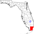
Location of Miami-Dade County in Florida
-
The flag of Miami-Dade County
-
The seal of Miami-Dade County
-

The logo of Miami-Dade County

See also
 In Spanish: Condado de Miami-Dade para niños
