
Miami River (Florida) facts for kids
Quick facts for kids Miami River |
|
|---|---|

The mouth of the Miami River at Brickell Key.
|
|
| Country | United States |
| Physical characteristics | |
| Main source | The Everglades Sea level |
| River mouth | Brickell Point 25°46′14″N 80°11′06″W / 25.7705°N 80.1851°W |
| Length | 5.5 mi (8.9 km) |
| Basin features | |
| Basin size | 2,800 sq mi (7,300 km2) |
The Miami River is a river in Florida, United States. It flows out of the Everglades and goes through the city of Miami. This river is about 5.5 miles (8.9 km) long. It starts where the Miami Canal ends, near Miami International Airport. The river then flows into Biscayne Bay.
Originally, the Miami River was a natural waterway. The Tequesta Indians lived near its mouth. Over time, the river was dredged (deepened) and changed. Today, it is an important part of Miami-Dade County. The mouth of the river is home to the Port of Miami. Many businesses here help keep the river in good condition.
Contents
What's in a Name? The Miami River's Story
Many people think the name "Miami" comes from a Native American word meaning "sweet water." However, the first time the name "Mayaimi" was used was by Hernando de Escalante Fontaneda. He was held captive by Native Americans for 17 years. He called what is now Lake Okeechobee the "Lake of Mayaimi" because it was very large.
The Mayaimi Indians were named after this big lake where they lived. Spanish records from 1710 mention a leader from "Maimi." Reports from a Spanish Mission in 1743 also talk about "Maymies" living nearby. The river has had other names too, like Garband River and Sweetwater River. It has been known as the Miami River since the Second Seminole War (1835–42).
How the Miami River Used to Be

In its natural state, the Miami River began with rapids. These rapids were formed by water from the Everglades flowing over a rocky area. This was about four miles (6.4 km) from where the river met the bay. In 1849, a survey reported that the water in the Everglades was about 6 feet (1.8 meters) above low tide. These rapids were later removed when the Miami Canal was dug. This was done to try and drain the wetland areas.
The river used to split into two main parts: a North Fork and a South Fork. This split happened about three miles (4.8 km) from its mouth. Each fork only went about one mile (1.6 km) before reaching more rapids. The North Fork had a stronger flow of water. There was also a smaller stream called Wagner Creek. It joined the river about 1.5 miles (2.4 km) from the mouth. The Miami River also got water from several natural springs. Sometimes, during dry periods, the river would stop flowing.
Early Life Along the River

The first known people to live around the Miami River were the Tequestas. Their main town was on the north side of the river, close to where it met the bay. Before Miami grew into a big city, the Tequesta people built mounds along the river.
Spanish missions were set up near the river for short periods in the 1500s and 1700s. However, the area was left empty when Spain gave Florida to Britain in 1765.
Settlers began to move to the Miami River area in the 1800s. The only time this stopped was during the Seminole Wars. The United States Army even tried to dig a channel through the sandbar at the river's mouth in 1856. They stopped when they decided not to make Fort Dallas a permanent base.
Changes to the River: Dredging and Pollution

Big changes to the river started when the Florida East Coast Railway arrived in Miami in 1896. A lot of digging and filling of the riverbanks took place. The rapids at the start of the South Fork were removed in 1908.
From 1909 to 1912, the Miami Canal was dug. This canal went around the rapids at the North Fork. When the canal was opened to the river in March 1912, a lot of mud and finely crushed stone from the digging washed into the river. This made the lower part of the river very muddy. Because of this, the river had to be dredged (deepened) three times in just two years.
Dredging of the river and connecting canals continued into the 1930s. Making the Miami River deeper helped drain the Everglades. However, this also caused saltwater intrusion. This means saltwater from the ocean moved further inland, making some drinking water wells unusable. By the 1940s, dams were built on the canals to stop saltwater from going too far inland.
The Miami River also became polluted. In 1897, Miami's first sewer line started dumping waste directly into the river. By the 1950s, 29 sewers were releasing untreated waste into the river. To fix this, Dade County built a sewage treatment plant on Virginia Key. Sewer lines were connected to it, sending the raw sewage away from the river.
The Miami River: A Busy Waterway
The Miami River is probably the shortest working river in the United States. In 2008, a report showed that trade through the Miami River port had doubled. It went from about 250,000 short tons in the early 1970s to about 500,000 in the early 2000s. Most of this trade is with other countries, especially nearby Caribbean nations like the Dominican Republic, Haiti, and the Bahamas. This is because the Miami River is good for smaller ships that can reach the shallower ports in the Caribbean.
The Miami River has many small cargo terminals. Here, smaller ships (up to about 230 feet or 70 meters long) load goods. Most of these goods are sent to ports in the Bahamas and other Caribbean countries.
Even though parts of the river are still polluted, things have gotten much better. Strict rules are now in place about ships dumping oil and waste. Laws against industrial dumping are also strongly enforced. The muddy bottom of the river still has some unwanted substances, though.
In the past, many ships were left abandoned in the river after their last trips. They would sink, making the river look bad and creating dangers for other boats. All of these abandoned ships have now been removed.
The U.S. Coast Guard now checks ships entering the Miami River very carefully. They make sure ships follow international and national rules for safety, building, maintenance, and crew. This has greatly reduced the number of unsafe ships sailing from the U.S.
In recent years, businesses along the river formed the Miami River Marine Group. This group works closely with law enforcement, the U.S. Coast Guard, and other agencies. They help keep communication open and work together. The river now acts like one big port with many different facilities and support services.
Many ships leaving the Miami River carry cargo to ports in Haiti. These ports include Port-au-Prince, Miragoâne, and Cap-Haïtien. The cargo usually includes dry foods like beans and rice, canned goods, clothes, household items, and used cars, trucks, and buses.
Years ago, some cargo terminals on the river were known for illegal activities. However, law enforcement and other agencies have stopped most of this. When new security rules for ships and ports came into effect in 2004, many chances for crime were removed.
Gallery
-
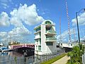
Miami River NW 5th Street Bridge
-
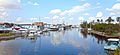
View upriver of the Miami River from NW 5th Street Bridge
-
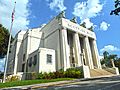
Scottish Rite Temple in the Lummus Park Historic District on the Miami River


Images for kids
-
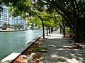
The new Miami Riverwalk as of May 2008. Here, people can walk along the river, eat at cafes, and shop.

See also
 In Spanish: Río Miami para niños
