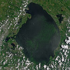
Lake Okeechobee facts for kids
Quick facts for kids Lake Okeechobee |
|
|---|---|
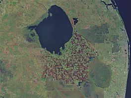
Photographed from space, 2000
|
|
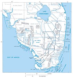
Shown at the top of this map of South Florida
|
|
| Location | Florida |
| Coordinates | 26°56′N 80°48′W / 26.933°N 80.800°W |
| Primary inflows | Kissimmee River, Fisheating Creek, Taylor Creek |
| Primary outflows | Everglades, Caloosahatchee River, St. Lucie River |
| Basin countries | United States |
| Max. length | 57.5 km (36 mi) |
| Max. width | 46.6 km (29 mi) |
| Surface area | 1,900 km2 (734 sq mi) |
| Average depth | 2.7 m (8 ft 10 in) |
| Max. depth | 3.7 m (12 ft) |
| Water volume | 5.2 km3 (1 cu mi) (estimated) |
| Residence time | 3 years |
| Surface elevation | 3.74 to 5.49 m (12 to 18 ft) |
| Islands | Kreamer, Torry, Ritta, Grass, Observation, Bird, Horse, Hog, Eagle Bay |
Lake Okeechobee is the biggest freshwater lake in the U.S. state of Florida. It is the eighth-largest natural freshwater lake in the United States. It is also the second-largest natural freshwater lake completely inside the lower 48 states, right after Lake Michigan.
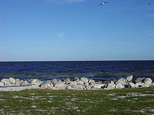
Lake Okeechobee covers about 730 square miles (1,900 km2). It is very shallow for its size, with an average depth of only 9 feet (2.7 metres). The lake is so big that you cannot see across it! The Kissimmee River, located north of the lake, is its main water source. The lake is split between five counties: Glades, Okeechobee, Martin, Palm Beach, and Hendry. All five counties meet near the center of the lake.
Contents
History of Lake Okeechobee
The first people known to live around Lake Okeechobee were the Calusa tribe. They called the lake Mayaimi, which means "big water." This name was reported in the 1500s.
Later, the name Okeechobee came from the Hitchiti words oki (water) and chubi (big). In the 1800s, it was sometimes called Mayacco Lake or Lake Mayaca. This was after the Mayaca people who moved near the lake. Today, the town of Port Mayaca keeps that old name.
On the southern edge of Lake Okeechobee, three islands—Kreamer, Ritta, and Torey—were once home to early settlers. These small towns had stores, post offices, and schools. People mainly farmed the rich but muddy land. By the 1960s, all these island settlements were empty.
When Palm Beach County was created in 1909, all of Lake Okeechobee was part of it. But in 1963, the lake was divided among the five counties that surround it.
Hurricanes and the Herbert Hoover Dike
In 1926, the Great Miami Hurricane hit the Lake Okeechobee area. It caused about 300 deaths. Two years later, in 1928, the Okeechobee Hurricane passed over the lake. This storm killed thousands of people. The Red Cross reported 1,836 deaths, but later the number was changed to at least 2,500.
Both disasters happened because of huge floods. Strong winds pushed water over the 6.6-foot (2-meter) mud dike that was around the lake. After these two hurricanes, the Florida government created the "Okeechobee Flood Control District."
This group worked with the U.S. Army Corps of Engineers to stop future floods. U.S. President Herbert Hoover visited the area. After his visit, the Corps designed a plan to build channels, gates, and nearly 140 miles of levees (raised banks) to protect the areas around the lake.
The Okeechobee Waterway opened in 1937. The new dike was named the "Herbert Hoover Dike" to honor the president. In the 1960s, the dike was made even bigger.
More recently, hurricanes like Frances, Jeanne, Wilma, and Irma did not cause major problems for communities around the lake. Even when the lake rose 18 inches (46 cm) after Hurricane Wilma in 2005, the dike held.
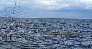
The Rim Canal
While building the dike, workers dug out earth along the inside edge of the lake. This created a deep channel called the rim canal. In some places, this canal is part of the main lake. In other spots, it is separated by low, grassy islands like Kreamer Island.
During dry times, the rim canal stays deep enough for boats. This is helpful when other parts of the lake are too shallow. Even when the water is high, the rim canal is often easier to navigate than the open lake. Boaters can use it to get close to their destination before going into the main lake.
Environmental Concerns
In 2007, during a dry period, water managers removed thousands of truckloads of polluted mud from the lake's bottom. They wanted to bring back the lake's natural sandy base. This would make the water clearer and better for wildlife. The mud had high levels of arsenic and other pesticides.
Sometimes, parts of the lake bed dry out and catch fire. In 2008, Tropical Storm Fay brought a lot of rain. Lake Okeechobee's water level rose by almost 4 feet (1.2 m).
In 2013, heavy rains caused a lot of dirty water to flow into the lake. The rising lake levels forced the Army Corps of Engineers (CoE) to release large amounts of polluted water. This water went into the St. Lucie River to the east and the Caloosahatchee River to the west. This flood of polluted fresh water harmed the natural balance of fresh and salt water in these areas.
Some people say that sugar farms have pumped polluted water from their fields into the lake. However, U.S. Sugar says they only pump water to prevent flooding in nearby communities, not to protect their farms. This pumping causes pollution problems for the Treasure Coast and other waterways.
In 2016, a large algal bloom covered 33 square miles (85 km2) of the southern part of the lake. This bloom was likely caused by nutrient-rich water flowing into the lake from farms and other sources. These blooms can produce toxins like Microcystin.
Geology of Lake Okeechobee
Lake Okeechobee sits in a shallow dip in the land. This dip also goes under the Kissimmee River Valley and the Everglades. About 6,000 years ago, this area was dry land. As sea levels rose and more rain fell, wetlands formed. Over time, water filled the area, creating the lake.
The bottom of the lake is made of limestone. Its deepest point is about 13 feet (4 m). The water can be cloudy because of runoff from nearby farms. The Army Corps of Engineers tries to keep the lake's surface between 12.5 and 15.5 feet (4 and 5 m) above sea level.
The lake is surrounded by the 40 feet (12 m) high Herbert Hoover Dike. This dike was built after a hurricane in 1928 caused massive flooding and killed many people.
Water flows into Lake Okeechobee from several places. The Kissimmee River is the biggest source, providing over 60% of the water. Fisheating Creek is the second largest source. Historically, water flowed out of the lake in a wide sheet into the Everglades. Today, most of the water leaves through canals that connect to coastal rivers.
Uses of Lake Okeechobee
The U.S. Army Corps of Engineers manages Lake Okeechobee for several important reasons:
- Flood Control: To protect nearby areas from floods and storms.
- Navigation: To allow boats to travel across the lake.
- Water Supply: To provide water for:
- Controlling salt levels in river mouths.
- Managing underground water.
- Watering farms.
- Supplying cities and businesses.
- Wildlife: To help fish and other wildlife thrive.
- Recreation: For fun activities like boating and fishing.
Florida National Scenic Trail
The 30-metre (100 ft) wide dike around Lake Okeechobee is part of the Lake Okeechobee Scenic Trail (LOST). This trail is also part of the much longer Florida National Scenic Trail. There is a well-kept paved path along most of the dike. Hikers and bicyclists use it.
Fishing in Lake Okeechobee
The most common fish found in Lake Okeechobee are largemouth bass, crappie, and bluegill. Sometimes, pickerel are also caught.
Lake Okeechobee's Ecosystem
Lake Okeechobee is a shallow lake known for its algal blooms. These blooms happen because of too many nutrients, like phosphorus, in the water. Algal blooms can harm the lake's plants and animals by releasing toxins. The plants in Lake Okeechobee are important for keeping oxygen in the water, which many aquatic creatures need.
Lake Characteristics
Lake Okeechobee is shallow, with an average depth of only 3 metres (9.8 ft). It is usually well-mixed by the wind. However, on calm, sunny days, the water can form layers, with less oxygen at the bottom. The water's clearness, or "transparency," changes with the seasons. It is usually less clear in winter and clearer in summer.
Animals (Fauna) of Lake Okeechobee
Lake Okeechobee is home to over 40 types of native fish. It also has some fish that were brought in, like the Mayan cichlid. Fish populations change depending on the season, water depth, and how clear the water is. More fish are born when water levels are higher, as this provides more places to hide and grow.
These fish are food for many wading birds, such as egrets, ibises, wood storks, and herons. Alligators also live in the lake. Fish in Lake Okeechobee eat small water insects and tiny animals called zooplankton. The lake also supports over 3,800 different types of arthropods (like insects and spiders) and about 400 types of nematodes (tiny worms).
Plants (Flora) of Lake Okeechobee
Water plants, called macrophytes, are very important for the lake. They help control nutrients, create homes for fish and insects, and provide oxygen through photosynthesis. They also help prevent too many nutrients from causing problems. However, too many nutrients and climate change can reduce the number of different macrophytes.
Since animals rely on these plants for food, shelter, and protection, fewer macrophytes can harm the animal populations. The amount of macrophytes depends on things like water depth, how clear the water is, and nutrient levels. When there are too many algae from nutrient pollution, they block sunlight, which harms the submerged macrophytes.
Some submerged plants found in Lake Okeechobee include southern naiad, Illinois pondweed, vallisneria, and hydrilla. The lake also has an invasive plant called torpedograss.
Eutrophication and Algal Blooms
High levels of phosphorus in Lake Okeechobee have been a concern since the 1970s. These levels can change based on how much runoff water enters the lake. For example, in 2005 and 2018, hurricanes caused a lot of runoff and brought in more phosphorus.
Even though efforts have been made to reduce phosphorus from farming, the lake has not reached its target for cleaner water. Too much phosphorus creates perfect conditions for harmful algal blooms (HABs).
Cyanobacteria (also called blue-green algae) are a type of bacteria that cause these blooms. They need nitrogen and phosphorus to grow. Since they can get nitrogen from the air and there's a lot of phosphorus in the lake, Lake Okeechobee is a perfect place for them to grow. The lake is also shallow and warm, which cyanobacteria like.

Cyanobacteria produce different toxins, including microcystin. These toxins are harmful to the environment and to humans. In 2016, Lake Okeechobee had a very large cyanobacteria bloom that lasted from May to mid-July. This bloom happened after a warm winter and a lot of rain from an El Niño event. More rain means more runoff, which brings more phosphorus into the lake, leading to more harmful algal blooms.
See also
 In Spanish: Lago Okeechobee para niños
 | Bessie Coleman |
 | Spann Watson |
 | Jill E. Brown |
 | Sherman W. White |


