
St. Lucie River facts for kids

The St. Lucie River is a 35-mile (56 km) long estuary in Florida, United States. It flows through St. Lucie and Martin counties. This river and its estuary are very important for the environment and the people living nearby. It's part of the larger Indian River Lagoon system. This lagoon is home to over 4,000 types of plants and animals. You can find amazing creatures here like manatees, oysters, dolphins, sea turtles, and seahorses.
Long ago, the St. Lucie was a freshwater river. It didn't connect to the Atlantic Ocean or Lake Okeechobee. But in 1892, people dug a channel to the Atlantic Ocean. Later, in the 1900s, the river was changed more. This was done for boats, flood control, and water supply. These changes turned the river into an estuary, which is a mix of fresh and saltwater.
Contents
Where is the St. Lucie River?
The St. Lucie River has two main parts: the North Fork and the South Fork. The North Fork starts in St. Lucie County and flows south. The South Fork, once called the Halpatiokee River, flows north. They meet near Stuart to form the main St. Lucie River.
From there, the main river flows east. It passes under several bridges, including the Florida East Coast Railway bridge and the new Roosevelt Bridge (part of U.S. Route 1). It then goes past Rio on the north side and Stuart on the south. Finally, it reaches the Indian River Lagoon near the St. Lucie Inlet, which leads to the Atlantic Ocean. You can even reach Lake Okeechobee from the river using the Okeechobee Waterway.
The main river goes through towns like Sewall's Point, Port Salerno, Stuart, and Jensen Beach. The South Fork flows near Palm City. While most of the river has a mix of salt and fresh water (brackish), the South Fork becomes much fresher further south. The North Fork also becomes more like a freshwater creek as you go north from White City. Its very beginning is in farmlands in St. Lucie County.
Environmental Concerns
Changes made to the St. Lucie River over time have caused problems with its water quality. The Okeechobee Waterway (also called the C-44 Navigational Canal) and other drainage canals have had a big impact. Water released from Lake Okeechobee often harms the river and the Indian River Lagoon.
This harmful water causes several issues:
- Nutrient Pollution: The water from Lake Okeechobee often has many nutrients from farm runoff. These nutrients can cause too much algae to grow.
- Other Pollutants: It also carries pollution from city streets and other urban areas. This pollution travels south from the Orlando suburbs into Lake Okeechobee.
- Murky Water: The water can be cloudy and full of tiny particles. These particles settle on the river bottom, creating a layer of muck.
- Dark Water: The freshwater also brings in dark substances. These make the water less clear, so sunlight can't reach plants and animals living deeper down.
- Salt Levels: The large amounts of freshwater drastically reduce the saltiness of the river. This makes it hard for plants and animals that need saltwater to survive.
In 2013, heavy rains made Lake Okeechobee levels rise very high. The U.S. Army Corps of Engineers had to release huge amounts of polluted water. This water flowed into the St. Lucie River and the Caloosahatchee River. This flood of polluted freshwater damaged the natural balance of fresh and saltwater in these areas.
Algae Blooms

Harmful algae blooms have been a problem in the St. Lucie River since the 1980s. These blooms happen when there's too much nutrient pollution and poor water quality. Warm temperatures also help them grow. In 2016, the river, Lake Okeechobee, and the Caloosahatchee River all had huge algae blooms.
These blooms are caused by a type of bacteria called cyanobacteria, or blue-green algae. They can cause serious health problems for animals in the water and for people living nearby. When algae blooms, it uses up oxygen in the water, which harms fish and other aquatic life. It can also create a slimy layer on the shores. Some algae can even make water taste bad or produce toxins. These toxins can poison animals and people.
Cyanobacteria toxins have been linked to brain problems like Alzheimer's disease, Parkinson's disease, and ALS. They can also cause liver problems, skin rashes, stomach cramps, nausea, and vomiting.
Metal Contamination
The St. Lucie River ecosystem also has metal pollution. In 2014, scientists found high levels of copper and zinc in many small creatures living on the river bottom. These levels were higher than what is considered safe for water quality.
How to Improve the River
Many groups are working to make the St. Lucie River and its estuary healthier. The South Florida Water Management District and its partners have several projects. These include:
- The St. Lucie River Watershed Protection Plan
- The Comprehensive Everglades Restoration Plan (CERP), which includes building a reservoir (C-44 Reservoir)
- Plans for the Lake Okeechobee Watershed
- Water Storage Strategies
- The Basin Management Action Plan
- Work on the Herbert Hoover Dike
- Restoring the Kissimmee River
- Studies on the Kissimmee Basin
St. Lucie River Watershed Protection Plan
This plan aims to reduce the amount of pollution entering the river. It will also set goals for how salty the water should be and how much freshwater should flow into the St. Lucie Estuary.
Images for kids
-
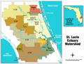
St. Lucie Estuary Watershed
-
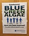
Flyer posted by Martin County's Martin Memorial Hospital warning residents about the 2016 algae blooms.
