
U.S. Route 1 facts for kids
Quick facts for kids
|
||||
|---|---|---|---|---|
 |
||||
| Route information | ||||
| Length | 2,369 mi (3,813 km) | |||
| Existed | 1926–present | |||
| Major junctions | ||||
| South end | Fleming Street in Key West, FL | |||
|
||||
| North end | ||||
| Location | ||||
| States: | Florida, Georgia, South Carolina, North Carolina, Virginia, District of Columbia, Maryland, Pennsylvania, New Jersey, New York, Connecticut, Rhode Island, Massachusetts, New Hampshire, Maine | |||
| Highway system | ||||
| United States Numbered Highways List • Bannered • Divided • Replaced
|
||||

U.S. Route 1 (often called US 1) is a very important highway in the eastern part of the United States. It's one of the longest roads in the country! This road stretches all the way from Key West, Florida, in the south, to the Canadian border in Fort Kent, Maine, in the north.
US 1 connects many big cities along the East Coast. These include Boston, New York, Philadelphia, Baltimore, Washington, DC, Richmond, Virginia, Raleigh, North Carolina, Augusta, Georgia, Jacksonville, Florida, and Miami. It's a key route for travel and trade.
Contents
What is U.S. Route 1?
U.S. Route 1 is a special kind of road called a U.S. Route. These roads are part of a national system that helps people travel across the country. US 1 is known for being super long, covering almost 2,370 miles (about 3,814 kilometers)! That's like driving from one end of the country to the other!
Where Does US 1 Go?
This highway runs through 15 different states and the District of Columbia. It starts in sunny Florida, goes through Georgia, South Carolina, North Carolina, Virginia, Maryland, Pennsylvania, New Jersey, New York, Connecticut, Rhode Island, Massachusetts, New Hampshire, and ends in Maine. It's a great way to see a lot of the East Coast!
Connecting Major Cities
US 1 is important because it links many of the biggest and most famous cities on the East Coast. Imagine being able to drive from the beaches of Florida to the forests of Maine, passing through major city centers like New York and Boston! For much of its journey, US 1 runs close to Interstate 95, another major highway. However, in some areas, like parts of North Carolina and Virginia, it goes further inland.
History of US 1
The path that U.S. Route 1 follows has a long and interesting history. Parts of this road were used hundreds of years ago!
Old Road Names
Some sections of US 1 were originally built in the 1800s. For example, a famous part of the road in the Northeast was known as the Boston Post Road. This was an important route for delivering mail and connecting early American towns. Later, in the 1900s, another part of the highway was called the Atlantic Highway. These old names show how important this route has been for a long time, helping people and goods move up and down the coast.
Images for kids
-
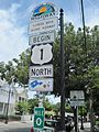
Mile zero in Key West, Florida. This is where US 1 officially begins!
-
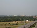
The skyline of Downtown Augusta, Georgia, as seen from US 1.
-
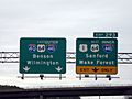
A sign showing US 1 joining I-40 on the Raleigh Beltline in North Carolina.
-
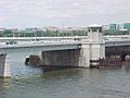
The 14th Street Bridge in Washington, D.C., which carries US 1.
-
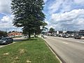
US 1 traveling along Roosevelt Boulevard in Philadelphia, Pennsylvania.
-
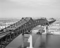
The impressive Pulaski Skyway in New Jersey, part of US 1.
-
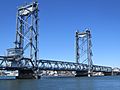
The Memorial Bridge connecting New Hampshire and Maine.
-
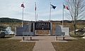
A monument in Fort Kent, Maine, marking the northern end of US 1.
-
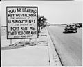
An old photo from 1951 showing the start of US 1 in Key West.


_April_2016.JPG)


See also
 In Spanish: U.S. Route 1 para niños
