
Washington, D.C. facts for kids
Quick facts for kids
Washington, D.C.
|
|||
|---|---|---|---|
| District of Columbia | |||
|
|
|||
|
|||
| Nickname(s):
D.C., The District
|
|||
| Motto(s):
Justitia Omnibus
(English: Justice for All) |
|||
| Anthem: "Washington" | |||

Neighborhoods of Washington, D.C.
|
|||

Washington, D.C.
Location in the United States

Washington, D.C.
Location in North America
|
|||
| Country | |||
| Residence Act | July 16, 1790 | ||
| Organized | February 27, 1801 | ||
| Consolidated | February 21, 1871 | ||
| Home Rule Act | December 24, 1973 | ||
| Named for |
|
||
| Government | |||
| • Type | Mayor–council | ||
| Area | |||
| • Federal capital city and district | 68.35 sq mi (177.0 km2) | ||
| • Land | 61.126 sq mi (158.32 km2) | ||
| • Water | 7.224 sq mi (18.71 km2) | ||
| Highest elevation | 409 ft (125 m) | ||
| Lowest elevation | 0 ft (0 m) | ||
| Population
(2020)
|
|||
| • Federal capital city and district | 689,545 | ||
| • Estimate
(2024)
|
702,250 | ||
| • Rank | 64th in North America 23rd in the United States |
||
| • Density | 11,280.71/sq mi (4,355.39/km2) | ||
| • Urban | 5,174,759 (US: 8th) | ||
| • Urban density | 3,997.5/sq mi (1,543.4/km2) | ||
| • Metro | 6,304,975 (US: 7th) | ||
| Demonym(s) | Washingtonian | ||
| GDP | |||
| • Federal capital city and district | 6.502 billion (2023) | ||
| • Metro | 4.685 billion (2023) | ||
| Time zone | UTC−05:00 (Eastern Time) | ||
| • Summer (DST) | UTC−04:00 (Eastern Daylight Time) | ||
| ZIP Codes |
20001–20098, 20201–20599, 56901–56999
|
||
| Area code(s) | 202 and 771 | ||
| ISO 3166 code | US-DC | ||
| Airports | |||
| Railroads |
Full list
|
||
.jpg)
.jpg)


.jpg)
.jpg)


Washington, D.C. is the capital city of the United States. It is also known as the District of Columbia, or simply D.C.. This special area is not part of any state. It sits on the Potomac River, bordering Virginia and Maryland. The city was named after George Washington, the first U.S. president. The "Columbia" part comes from a poetic name for the United States.
The U.S. Constitution created a special federal district. This district would be under the direct control of the U.S. Congress. This means Washington, D.C., is not a state itself. It is also not part of any other state. In 1790, a law called the Residence Act approved creating this capital district. It was built along the Potomac River. The city was founded in 1791. The U.S. capital moved from Philadelphia to Washington, D.C., in 1800.
A French engineer named Pierre Charles L'Enfant designed the city in 1791. It has wide streets and avenues that spread out from central points. The city is divided into four sections called quadrants. These sections meet at the Capitol Building. Washington, D.C., has many neighborhoods.
In 2020, about 689,545 people lived in Washington, D.C. During the workweek, over one million people are in the city. This is because many people commute from nearby Maryland and Virginia. The larger Washington metropolitan area includes parts of these states. It is the seventh-largest metropolitan area in the country. About 6.3 million people lived there in 2023.
Since 1973, Washington, D.C., has been led by a locally elected mayor. It also has a 13-member council. However, Congress can still change local laws. People in Washington, D.C., do not have voting representatives in Congress. They elect one delegate who can speak but not vote in the House of Representatives. Since 1961, D.C. residents can vote for the U.S. president.
Washington, D.C., is a very important world capital. It is home to the U.S. federal government. You can find famous buildings here like the White House, the Capitol, and the Supreme Court Building. The city also has many national monuments and museums. Most of these are on or near the National Mall. Examples include the Jefferson Memorial and the Lincoln Memorial. Many countries have their embassies here. Important international groups like the World Bank also have their main offices in D.C.
Contents
History of Washington, D.C.
Early History and Founding
When Europeans first arrived in the early 1600s, Algonquian-speaking tribes lived around the Potomac River. These included the Piscataway people. Conflicts with European settlers and other tribes caused the Piscataway people to move.
Before Washington, D.C., nine other cities served as capitals for the U.S. government. New York City was the first capital under the Constitution. Then Philadelphia was the capital from 1790 to 1800. In 1783, Congress decided to look for a new capital location. They wanted it near the Delaware or Potomac Rivers.
James Madison wrote in 1788 that the new federal government needed its own capital. This would help it stay safe and run smoothly. An event in 1783, where soldiers protested, showed that the government needed to be independent.
The U.S. Constitution allows for a special "District" to be the seat of government. This district could be up to ten miles square. It would be given by states and accepted by Congress. The Constitution did not say where the capital should be. In 1790, leaders agreed to pay states' Revolutionary War debts. In return, the new capital would be in the Southern United States.
On July 9, 1790, Congress passed the Residence Act. This law approved a national capital on the Potomac River. President George Washington chose the exact spot. He signed the law on July 16, 1790. The district was formed from land given by Maryland and Virginia. It was a square, ten miles on each side.
Two towns, Georgetown and Alexandria, were already in this area. In 1791 and 1792, a team surveyed the district's borders. This team included Andrew Ellicott and Benjamin Banneker. They placed stone markers at each mile. Many of these stones are still there.
The new federal city was built on the north bank of the Potomac River. It was east of Georgetown. On September 9, 1791, the city was named Washington. This honored President Washington. The district was named Columbia. This was a poetic name for the United States. Congress met there for the first time on November 17, 1800.
In 1801, Congress passed a law that officially organized the district. It placed the whole area under federal control. People in the district were no longer considered residents of Maryland or Virginia. This meant they lost their representation in Congress.
Burning During the War of 1812

On August 24, 1814, during the War of 1812, British forces attacked Washington, D.C. They burned government buildings. This included the United States Capitol, the Treasury Building, and the White House. This event is known as the burning of Washington. A storm forced the British to leave after only 24 hours. Most buildings were quickly fixed. The Capitol, still being built, was not finished until 1868.
Changes and Growth

In the 1830s, the southern part of the district, Alexandria, faced economic problems. Its citizens asked Virginia to take back the land. This process is called retrocession. In 1846, Congress agreed to return the land Virginia had given. This left the district with only the land from Maryland.
The American Civil War began in 1861. The federal government grew, and many freed slaves moved to the city. President Abraham Lincoln signed the Compensated Emancipation Act in 1862. This ended slavery in the district. About 3,100 enslaved people became free. In 1868, African American men in the district gained the right to vote in local elections.
By 1870, the district's population had grown to nearly 132,000 people. But the city still lacked paved roads and good sanitation. Some in Congress wanted to move the capital further west. However, President Ulysses S. Grant said no.
In 1871, Congress combined the cities of Washington and Georgetown. They also got rid of Washington County. This created one single government for the whole District of Columbia. This made the "city of Washington" the same as the "District of Columbia."
Modern Era and Home Rule

In 1961, the Twenty-third Amendment was passed. This gave Washington, D.C., three votes in the Electoral College for presidential elections. But residents still could not vote for members of Congress.
After Martin Luther King Jr. was assassinated in 1968, there were riots in the city. Many buildings were burned. Rebuilding took many years.
In 1973, Congress passed the District of Columbia Home Rule Act. This law allowed D.C. to elect its own mayor and council. In 1975, Walter Washington became the first elected mayor. He was also the first black mayor.
Since the 1980s, there have been efforts to make D.C. a state. In 2016, D.C. voters strongly supported statehood. A bill to make D.C. a state passed the House of Representatives in 2021. However, it did not pass in the Senate.
Geography and Climate
Where is Washington, D.C.?

Washington, D.C., is on the U.S. East Coast. It covers about 68 square miles. About 61 square miles are land, and 7 square miles are water. The district shares borders with Montgomery County, Maryland, Prince George's County, Maryland, Arlington County, Virginia, and Alexandria, Virginia.
The Potomac River forms the border with Virginia. The Anacostia River and Rock Creek are two important rivers in D.C. The highest point in the city is at Fort Reno Park. It is 409 feet above sea level. The lowest point is at the Potomac River, which is sea level.
Washington, D.C., has a lot of parkland. About 19% of the city is parks. This is the second-highest amount among big U.S. cities. The National Park Service manages most of the parkland. Rock Creek Park is a large urban forest. It is one of the country's oldest national parks. It has many plants and animals like raccoons, deer, and owls.
Weather in Washington, D.C.

Washington has a humid subtropical climate. This means summers are hot and humid. The average temperature in July is about 80°F. The humidity can make it feel even hotter. Thunderstorms are common in summer.
Winters are cool to cold. Snow happens, but the amount varies. Big snowstorms, called nor'easters, can affect the East Coast. The biggest snowfall recorded was 28 inches in 1922.
Hurricanes sometimes affect the area in late summer or early fall. But they are usually weaker by the time they reach Washington. Flooding from the Potomac River can cause damage in Georgetown. Rain falls throughout the year.
The hottest temperature ever recorded was 106°F in 1918 and 1930. The coldest was -15°F in 1899.
City Layout and Buildings
How the City Was Designed
.jpg)
Washington, D.C., was a planned city. Pierre Charles L'Enfant designed the capital in 1791. His plan included wide streets and avenues. These streets spread out from central points. He also planned for open spaces and gardens. The National Mall was part of his vision. It was inspired by famous gardens in France.
By the early 1900s, parts of L'Enfant's plan were not followed. Congress created a committee to improve the city. The McMillan Plan in 1901 helped restore L'Enfant's original design. It added more parks and cleared slums.
There is a law about building heights in D.C. The Height of Buildings Act of 1910 limits how tall buildings can be. This is why the city's skyline is low and spread out. This law helps keep the views of monuments clear.
Washington, D.C., is divided into four sections: Northwest (NW), Northeast (NE), Southeast (SE), and Southwest (SW). These sections meet at the U.S. Capitol. All street names include the section abbreviation. Streets are mostly in a grid pattern. East-west streets have letters, and north-south streets have numbers. Diagonal avenues are often named after states.
Some streets are very famous. Pennsylvania Avenue connects the White House to the Capitol. K Street is known for its many lobbying offices. Constitution Avenue and Independence Avenue are on either side of the National Mall. They have many museums. Washington, D.C., has 177 foreign embassies. Many are on Massachusetts Avenue, also known as "Embassy Row."
- Selection of neighborhoods in Washington, D.C.
-
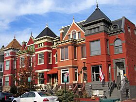
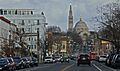
Bloomingdale
-
Columbia Heights
-
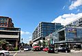
Edgewood
-
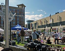
Navy Yard


_(cropped).jpg)

.jpg)
.jpg)

Architecture and Styles

Washington, D.C., is famous for its architecture. Many buildings are inspired by ancient Roman and Greek styles. This is called Neoclassical style. The White House, the U.S. Capitol, and the Supreme Court Building are examples. They have large columns and domes.
Other styles can also be seen. The Eisenhower Executive Office Building is in the French Second Empire style. The Watergate complex is a modern style. The Smithsonian Institution Building is built of red sandstone. It is in the Norman Revival style.

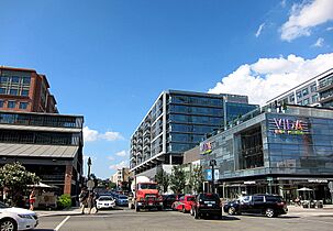
Newer buildings show modern designs. The Wharf has high-rise buildings with glass exteriors. CityCenterDC has sleek glass and metal buildings.
Outside downtown, buildings are more varied. Many historic homes are in Victorian styles. Rowhouses are common in areas built after the Civil War. The Old Stone House in Georgetown was built in 1765. It is the oldest building in the city. Georgetown University has a mix of Romanesque and Gothic Revival styles.
People and Culture
Population and Diversity
| Historical population | |||
|---|---|---|---|
| Census | Pop. | %± | |
| 1800 | 8,144 | — | |
| 1810 | 15,471 | 90.0% | |
| 1820 | 23,336 | 50.8% | |
| 1830 | 30,261 | 29.7% | |
| 1840 | 33,745 | 11.5% | |
| 1850 | 51,687 | 53.2% | |
| 1860 | 75,080 | 45.3% | |
| 1870 | 131,700 | 75.4% | |
| 1880 | 177,624 | 34.9% | |
| 1890 | 230,392 | 29.7% | |
| 1900 | 278,718 | 21.0% | |
| 1910 | 331,069 | 18.8% | |
| 1920 | 437,571 | 32.2% | |
| 1930 | 486,869 | 11.3% | |
| 1940 | 663,091 | 36.2% | |
| 1950 | 802,178 | 21.0% | |
| 1960 | 763,956 | −4.8% | |
| 1970 | 756,510 | −1.0% | |
| 1980 | 638,333 | −15.6% | |
| 1990 | 606,900 | −4.9% | |
| 2000 | 572,059 | −5.7% | |
| 2010 | 601,723 | 5.2% | |
| 2020 | 689,545 | 14.6% | |
| 2024 (est.) | 702,250 | 16.7% | |
| Source: Note: 2010–2020 |
|||
| Demographic profile | 2020 | 2010 | 1990 | 1970 | 1940 |
|---|---|---|---|---|---|
| White | 39.6% | 38.5% | 29.6% | 27.7% | 71.5% |
| —Non-Hispanic whites | 38.0% | 34.8% | 27.4% | 26.5% | 71.4% |
| Black or African American | 41.4% | 50.7% | 65.8% | 71.1% | 28.2% |
| Hispanic or Latino (of any race) | 11.3% | 9.1% | 5.4% | 2.1% | 0.1% |
| Asian | 4.8% | 3.5% | 1.8% | 0.6% | 0.2% |
.png)
The population of Washington, D.C., has grown since 2000. In 2019, about 705,749 people lived there. The city's population is boosted by commuters during the day. The larger Washington metropolitan area has about six million residents.
Washington, D.C., has always had a large African American population. In 2020, about 41.4% of the population was Black or African American. The city is also home to many immigrants. Major groups come from El Salvador, Ethiopia, Mexico, and China.
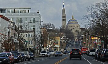
The city has a diverse mix of religions. Many different churches, mosques, and synagogues can be found here. The Basilica of the National Shrine of the Immaculate Conception is the largest Catholic church in the U.S. The Islamic Center of Washington was once the largest mosque in the Western Hemisphere.
Arts and Music Scene
| Dance | Hand dancing |
|---|---|
| Bird | Wood Thrush |
| Fish | American shad |
| Flower | American Beauty rose |
| Tree | Scarlet Oak |

Washington, D.C., is a major center for the arts. The John F. Kennedy Center for the Performing Arts is a famous venue. It hosts the National Symphony Orchestra and the Washington National Opera. The Kennedy Center also gives out special awards each year. These awards honor people who have made great contributions to American culture.
The historic Ford's Theatre is where President Abraham Lincoln was assassinated. It still works as a theater and a museum today. The United States Marine Band is the country's oldest professional music group. It was founded in 1798.
The U Street Corridor was once called "Washington's Black Broadway." It was a hub for jazz music. Famous musicians like Duke Ellington started their careers here. Today, this area is known for its bars, restaurants, and theaters.
.jpg)
Washington has its own music style called go-go. It is a type of rhythm and blues music. It became popular in the 1970s. The city is also important for indie music. The record label Dischord Records helped create punk and indie rock music.
Food and Dining

Washington, D.C., has many different kinds of restaurants. You can find food from all over the world. The city's Chinatown has many Chinese restaurants. D.C. is especially known for its Ethiopian cuisine. Many Ethiopian immigrants moved here in the 20th century. A part of the Shaw neighborhood is called "Little Ethiopia."
Some foods were created in Washington, D.C. The half-smoke is a famous sausage. It is served in a bun with chili and cheese. Mumbo sauce is a sweet and tangy sauce. It is often used on meat and fries. The city also popularized the jumbo slice pizza.
.jpg)
Ben's Chili Bowl is a famous restaurant on U Street. It opened in 1958. It is known for its chili dogs and half-smokes. Many presidents and celebrities have visited it.
Museums and Landmarks
Smithsonian Museums
.jpg)
Washington, D.C., has some of the most visited museums in the world. The Smithsonian Institution manages most of the city's official museums. It is a large research and museum complex. The U.S. government helps fund the Smithsonian. All its museums are free to visit.
The National Museum of Natural History is the most visited Smithsonian museum. Other Smithsonian museums on the National Mall include:
- National Air and Space Museum
- National Museum of African Art
- National Museum of American History
- National Museum of the American Indian
- Sackler and Freer galleries (Asian art)
- Hirshhorn Museum and Sculpture Garden
- Arts and Industries Building
- Smithsonian Institution Building (headquarters)
The Smithsonian American Art Museum and the National Portrait Gallery are in the Old Patent Office Building. The National Zoo is also a Smithsonian museum.
Other Museums

The National Gallery of Art is on the National Mall. It has American and European art. It is owned by the U.S. government but is not part of the Smithsonian. The National Building Museum has exhibits on architecture and design. The Botanic Garden is a museum of plants.
There are also private museums. These include the National Museum of Women in the Arts and The Phillips Collection. The United States Holocaust Memorial Museum has exhibits about the Holocaust.
Famous Landmarks

The National Mall is a large park in downtown Washington. It stretches almost two miles. It goes from the Lincoln Memorial to the United States Capitol. The Mall often hosts protests, concerts, and festivals. It is also where presidential inaugurations happen.
The Washington Monument is near the center of the Mall. The National World War II Memorial, the Korean War Veterans Memorial, and the Vietnam Veterans Memorial are also on the Mall.

South of the Mall is the Tidal Basin. It is a human-made lake. Japanese cherry trees line its paths. Every spring, the cherry blossoms bloom. This attracts visitors from all over the world. The National Cherry Blossom Festival celebrates this event. The Jefferson Memorial and the Martin Luther King Jr. Memorial are around the Tidal Basin.
.jpg)
Many other landmarks are outside the National Mall. These include the Old Post Office and the National Cathedral. The National Archives building holds important documents. These include the Declaration of Independence and the Constitution. The Library of Congress is the largest library in the world. The United States Supreme Court building is next to it.
Chinatown is north of the National Mall. It has the Capital One Arena. This arena is home to the city's basketball and hockey teams. Chinatown also has many Chinese restaurants and shops. The Friendship Archway is a large Chinese ceremonial archway.
The Southwest Waterfront has been redeveloped. It is now a popular cultural center. The Wharf has the historic Maine Avenue Fish Market. This is the oldest fish market in the United States. The Wharf also has hotels, restaurants, and live music venues.
Parks and Green Spaces
.jpg)
Washington, D.C., has many parks, gardens, and squares. The city has 683 parks. Almost a quarter of its land area is green space. This means 99% of residents live close to a park.
Rock Creek Park is the largest park in the city. It is in Northwest D.C. Lafayette Square is a historic public square. It is north of the White House. It has been the site of many protests and speeches.
.jpg)
There are several islands in the Potomac River. Theodore Roosevelt Island has a memorial and trails. Columbia Island has a memorial and a marina.
West Potomac Park is south of the Lincoln Memorial. It has several national landmarks. These include the Korean War Veterans Memorial and the Jefferson Memorial.
Other parks include Dumbarton Oaks, Meridian Hill Park, and Anacostia Park. The city also has many traffic circles with parks in the middle. Examples are Dupont Circle and Logan Circle. The United States National Arboretum is a large garden in Northeast D.C. It has many trees and trails.
Sports in D.C.
.jpg)
Washington, D.C., has teams in all four major professional men's sports. It also has two major professional women's teams. The Washington Nationals (baseball) are very popular. They play at Nationals Park. The Washington Commanders (football) play in nearby Maryland.
The Washington Wizards (basketball) and the Washington Capitals (hockey) play at Capital One Arena. The Washington Mystics (women's basketball) play at Entertainment and Sports Arena. D.C. United (men's soccer) and the Washington Spirit (women's soccer) play at Audi Field.
D.C. teams have won 14 professional championships. The Commanders have won three Super Bowls. D.C. United has won four championships. The Wizards, Capitals, Mystics, Nationals, and Spirit have each won one.

The city also hosts the Washington Open tennis tournament. Two major marathons are held here each year. These are the Marine Corps Marathon and the Rock 'n' Roll USA Marathon.
The city has four NCAA Division I college teams. These are from American University, George Washington University, Georgetown University, and Howard University. The Georgetown men's basketball team is very well known.
Federal Voting Rights


Congress has always controlled the federal district. For a long time, people living there could not vote in federal elections. This changed in 1961. The 23rd Amendment gave Washington, D.C., three votes in presidential elections. This is the same number of votes as the smallest state.
However, Washington, D.C., is not a state. So, its residents do not have voting representatives in Congress. They elect a delegate to the House of Representatives. This delegate can speak and propose laws but cannot vote on the House floor. D.C. has no official representation in the United States Senate.
Even though they don't have full representation, D.C. residents pay all federal taxes. In 2012, they paid more federal taxes than people in 19 states. Many people in D.C. want full voting rights. Their license plates say, "End Taxation Without Representation." Polls show that most Americans think D.C. should have voting representation.
Some people are against D.C. having full voting rights. They say the Founding Fathers did not intend for the district to have a vote. They also say making D.C. a state would give too much power to one city.
In 2021, a bill to make D.C. a state passed the House of Representatives. But it did not pass in the Senate. Another idea is to return the district's land to Maryland. This would give D.C. residents normal state representation.
Education in D.C.
_(cropped).jpg)
The District of Columbia Public Schools (DCPS) runs the city's public schools. In 2010–11, about 46,191 students were in public schools. D.C. also has public charter schools. Many students choose charter schools. The city also has private schools.
Colleges and Universities

Washington, D.C., has many universities. The University of the District of Columbia (UDC) is a public university. Other universities include:
- American University (AU)
- Gallaudet University
- George Washington University (GWU)
- Georgetown University (GU)
- Howard University (HU)
- Catholic University of America (CUA)
- Johns Hopkins University Paul H. Nitze School of Advanced International Studies (SAIS)
- Trinity Washington University
The city also has medical schools and hospitals.
Libraries
Washington, D.C., has many libraries. The District of Columbia Public Library system has 26 branches. The Folger Shakespeare Library has the world's largest collection of items about William Shakespeare.

The Library of Congress is the official library for the U.S. Congress. It is also the national library. It has three buildings on Capitol Hill. It is the world's largest library. It has over 173 million items.
Media in D.C.

Washington, D.C., is a major center for news. The Washington Post is the most widely read local newspaper. It is also one of the most important newspapers in the U.S. The Washington Times is another daily newspaper. The Washington City Paper is a popular weekly paper.
Magazines like The Atlantic and National Geographic are based here. Political publications like Politico also have offices in D.C.

Many media companies have headquarters in the Washington area. These include C-SPAN, National Geographic Channel, and National Public Radio (NPR). Voice of America, the U.S. government's news service, is also in D.C.
Transportation
Getting Around D.C.
.jpg)
Washington, D.C., has about 1,500 miles of streets and avenues. Many planned highways were never built. This was due to protests in the 1960s. Instead, money went to public transportation.
Traffic can be bad in Washington. But many people use public transportation. About 37% of commuters take public transit. Others walk or bike to work.
Biking and Walking

The city has expanded its bike lane network. In 2022, it had 104 miles of bike lanes. D.C. is part of the Capital Bikeshare program. This is one of the largest bike-sharing systems in the country.
Washington, D.C., is a very walkable city. In 2021, it was ranked the fifth-most walkable city in the U.S. Popular walkable neighborhoods include U Street and Dupont Circle.
Crossing Rivers

Many bridges cross the Potomac and Anacostia Rivers. These bridges carry cars, trains, pedestrians, and bikes. Examples include Arlington Memorial Bridge and Francis Scott Key Bridge.
Ferries and water cruises also cross the Potomac River. The Potomac Water Taxi connects different waterfront areas.
Trains and Buses
_052.jpg)
The Washington Metropolitan Area Transit Authority (WMATA) runs the Washington Metro. This is the city's subway system. It has six lines and 98 stations. Metro is the second-busiest subway system in the U.S. It is known for its unique vaulted ceilings.
Washington Union Station is the city's main train station. It serves about 70,000 people daily. It is Amtrak's second-busiest station. Commuter trains like MARC and VRE also use Union Station.

The Metrobus system is the main public bus system. It serves over 400,000 riders each weekday. The city also has the DC Circulator bus system. It connects popular areas for only $1.
Airports

Three major airports serve Washington, D.C., but none are inside the city.
- Ronald Reagan Washington National Airport is the closest. It is in Arlington, Virginia. It mainly handles domestic flights.
- Baltimore/Washington International Airport (BWI) is in Maryland. It is the busiest by total passengers.
- Washington Dulles International Airport is in Virginia. It handles the most international flights.
The U.S. president does not use these airports for travel. The president usually takes Marine One from the White House to Joint Base Andrews. From there, they take Air Force One.
Utilities

The District of Columbia Water and Sewer Authority (D.C. Water) provides drinking water and wastewater services. They get water from the Potomac River. The water is treated and stored in reservoirs.
Pepco is the city's electric company. Many power lines in downtown Washington are underground. This is due to a law from 1889. Washington Gas provides natural gas. It installed the city's first gas lights in 1848.
D.C. National Guard
The D.C. National Guard is different from state National Guards. The president of the United States, not city officials, can deploy it. The president can also take control of the police force in emergencies.
Sister Cities
Washington, D.C., has fifteen official sister city agreements. Most of these cities are national capitals.
 Bangkok, Thailand (1962)
 Dakar, Senegal (1980)
 Beijing, China (1984)
 Brussels, Belgium (1985)
 Athens, Greece (2000)
 Paris, France (2000)
 Pretoria, South Africa (2002)
 Seoul, South Korea (2006)
 Accra, Ghana (2006)
 Sunderland, United Kingdom (2006)
 Rome, Italy (2011)
 Ankara, Turkey (2011)
 Brasília, Brazil (2013)
 Addis Ababa, Ethiopia (2013)
 San Salvador, El Salvador (2018)
Images for kids
-

Bloomingdale
-

Columbia Heights
-
Edgewood
-
Navy Yard
See also
 In Spanish: Washington D. C. para niños
