
Accra facts for kids
Quick facts for kids
Accra
|
||
|---|---|---|
|
Accra central skyline
Schoolchildren celebrating Ghana's Independence Day at Black Star Square
National Theatre
University of Ghana Great Hall
King Tackie Tawia I statue
Jamestown Lighthouse
The Octagon
West Ridge
Labadi Beach
General Post Office
|
||
|
||

Accra
Location in Ghana

Accra
Location in Africa
|
||
| Country | ||
| Region | Greater Accra Region | |
| Districts |
13 districts
Accra Metropolitan District, La Dade Kotopon Municipal District, Ledzekuku Municipal District, Krowor Municipal District, Okaikwei North Municipal District, Ablekuma North Municipal District, Ablekuma Central Municipal District, Ablekuma West Municipal District, Ayawaso East Municipal District, Ayawaso North Municipal District, Ayawaso Central Municipal District, Ayawaso West Municipal District, Korle Klottey Municipal District
|
|
| Settled | 15th century | |
| Area | ||
| • Accra Metropolitan | 20.4 km2 (7.9 sq mi) | |
| • Urban | 199.4 km2 (77.0 sq mi) | |
| • Metro | 3,245 km2 (1,253 sq mi) | |
| Elevation | 61 m (200 ft) | |
| Population
(2021 census)
|
||
| • Accra Metropolitan | 284,124 | |
| • Density | 13,930/km2 (36,070/sq mi) | |
| • Urban | 1,782,150 | |
| • Urban density | 8,937.6/km2 (23,148/sq mi) | |
| • Metro | 5,455,692 | |
| • Metro density | 1,681.26/km2 (4,354.4/sq mi) | |
| Demonym(s) | Accran | |
| Time zone | UTC+00:00 (Greenwich Mean Time) | |
| • Summer (DST) | (Not Observed) | |
| Postcode districts |
GA, GL, GZ
|
|
| Area code(s) | 030 | |


.jpg)

.jpg)


Accra is the capital and largest city in Ghana. It is located on the southern coast, right by the Gulf of Guinea. This gulf is part of the huge Atlantic Ocean.
As of 2021, the main Accra Metropolitan District has about 284,124 people. The larger Greater Accra Region has over 5.4 million people. When people say "Accra," they often mean the bigger area that was once the Accra Metropolitan District before 2008. This area is now split into 13 smaller local government districts.
Accra was formed when different settlements grew together. These settlements were around British Fort James, Dutch Fort Crêvecoeur, and Danish Fort Christiansborg. Accra became the capital of the British Gold Coast in 1877. It has grown into a modern city since Ghana became independent in 1957. The buildings in Accra show its long history, from old colonial styles to modern skyscrapers.
Today, Accra is the main place for business and government in the Greater Accra Region. It is also a very important city in Africa. In 2020, experts called Accra a "Gamma −" level global city. This means it has a growing influence around the world.
Contents
- What Does "Accra" Mean?
- Accra's History
- Accra's Weather and Environment
- How Accra is Governed
- Accra's City Layout
- People and Homes in Accra
- Accra's Economy
- Education in Accra
- Transportation in Accra
- Sports in Accra
- Places of Worship
- Culture and Tourism
- Sister Cities
- UNESCO World Book Capital
- See Also
- Images for kids
What Does "Accra" Mean?
The name Accra comes from the Akan word Nkran. This word means "ants." It was used because there were many anthills in the countryside around Accra. The name specifically refers to soldier ants. The Twi speakers used this name for both the town and its people.
In the local Ga language, Accra is called Ga or Gaga. This is the same name as the Ga people. Historians believe the name links the Ga people's fighting spirit to the way soldier ants behave. Anthills were even seen as sacred places.
The Ga people used the idea of swarming ants to show their military strength. They used it to remember their old victories over other groups in the Accra Plains. The name Ga is also related to the name Akan.
Europeans changed Nkran to Accra. The Danes used to spell it Akra.
Accra's History

The main Ga group, led by Ayi Kushie, arrived in the area by sea. When the Guan people saw them in their canoes, they thought they looked like ants. So, they called them Nkran (ants). This name later became Akra by the Danes, and then Accra. The Ga people also started calling themselves Ga. Because so many Ga people arrived, the local Larteh people moved away.
At first, Accra was not the biggest trading center. Other ports like Ada and Prampram were more important. The Dutch, British, and Swedes built forts in the area. By the 17th century, Portugal, France, and Denmark also had forts in the city.
Britain slowly took over the interests of other countries. In 1851, Denmark sold its forts, including Christiansborg, to the British. The Netherlands sold their forts in 1871. In 1873, after many disagreements with the Ashantis, the British captured Kumasi.
In 1874, the British captured Accra. In 1877, after a war, Accra became the capital of the British Gold Coast. This was because Accra had a drier climate than the previous capital, Cape Coast. At this time, Accra was only between Ussher Fort and the Korle Lagoon.
As Accra became the new capital, more British officials and European settlers moved in. The city grew to make space for them. Victoriaborg was created in the late 1800s as a neighborhood just for Europeans. In 1908, Accra expanded even more. A new neighborhood, Adabraka, was built for the local people to help with overcrowding.

A very important decision was made in 1908: to build the Accra-Kumasi railway. This railway connected Accra, which was the main port, to Ghana's cocoa-producing areas. By 1923, the railway was finished. By 1924, cocoa was Ghana's biggest export.
The colonial period greatly shaped Accra. For example, European and African neighborhoods were kept separate by law until 1923. New buildings had to be made of stone or concrete. However, European settlers did not want to spend much money on the city's infrastructure. This changed when Sir Frederick Gordon Guggisberg became governor. During his time, the three separate settlements (Osu, La, and Jamestown) joined to become modern Accra. Guggisberg's government planned the street layouts for areas like Tudu and Adabraka.
Guggisberg also built a bridge over the Korle Lagoon in 1923. This opened up land west of the lagoon for new settlements. He also oversaw the building of a major hospital (Korle-Bu) and a secondary school (Achimota). These improvements made more people move to Accra from rural areas. More British business people and officials also came to the city.
After World War II

After World War II, neighborhoods like Ridge and Cantonments were planned for Europeans. Many people from rural areas moved into places like Nima, which were not yet part of Accra. These areas grew without government planning, leading to crowded, unplanned settlements.
The central business district (CBD) also developed. More government buildings were built on High Street. The growing economy led to many more commercial buildings in the CBD.
In 1948, Ghana was still a British colony. The chief of Osu Alata, Nii Kobina Bonney III, called for a boycott of European goods. This was because prices for important items were rising. At the same time, war veterans were asking for their promised pay. On February 28, 1948, unarmed ex-servicemen marched towards Christiansborg Castle. They wanted to give a petition to the colonial governor. However, the colonial police chief ordered them to stop, and they were fired upon. Three leaders were killed, including Sergeant Nii Adjetey, who now has a memorial in Accra.
Plans for Accra's Future

In 1944, a city planner named Maxwell Fry made a plan for Accra. This plan was updated in 1958. It showed how the British wanted Accra to grow. They wanted to reorganize the CBD and develop the coastal area. They also planned for many public squares, fountains, and statues. However, the British rule in the Gold Coast ended before this plan could be fully carried out.
When Kwame Nkrumah became Ghana's first Prime Minister in 1957, he made his own plan for Accra. He wanted to create places that would make Ghanaians proud and inspire nationalism. Instead of fountains, he built landmarks like Independence Square and the State House. He also improved Christiansborg Castle. Nkrumah wanted these places to be important symbols for the country.
Today, Accra is built around the original British, Danish, and Dutch forts. These include Jamestown (near James Fort), Osu (near Christiansborg, now Osu Castle), and Ussherstown (near Ussher Fort).
Popular places to visit include the National Museum of Ghana, the National Theatre, and the Jamestown Lighthouse. Important government buildings like the Parliament and Supreme Court of Ghana are also in Accra.
The city is also a major transport hub. It has the Kotoka International Airport and railway links to other cities.
Accra's Weather and Environment
| Weather chart for Accra | |||||||||||||||||||||||||||||||||||||||||||||||
|---|---|---|---|---|---|---|---|---|---|---|---|---|---|---|---|---|---|---|---|---|---|---|---|---|---|---|---|---|---|---|---|---|---|---|---|---|---|---|---|---|---|---|---|---|---|---|---|
| J | F | M | A | M | J | J | A | S | O | N | D | ||||||||||||||||||||||||||||||||||||
|
15
31
23
|
33
31
24
|
56
31
24
|
81
31
24
|
142
31
24
|
178
29
23
|
46
27
23
|
15
27
22
|
36
27
23
|
64
29
23
|
36
31
24
|
23
31
24
|
||||||||||||||||||||||||||||||||||||
| temperatures in °C precipitation totals in mm source: BBC Weather |
|||||||||||||||||||||||||||||||||||||||||||||||
|
Imperial conversion
|
|||||||||||||||||||||||||||||||||||||||||||||||
Accra has a tropical wet and dry climate. This means it has a rainy season and a dry season. The average rainfall is about 730 mm per year. Most rain falls during two rainy seasons. The main one is from April to mid-July. A smaller one happens in October. Rain often comes in short, heavy storms. These can cause local flooding if drains are blocked.
The temperature does not change much throughout the year. The average monthly temperature is around 25.9°C in August (coolest) to 29.6°C in March (hottest). The "cooler" months are usually more humid. The warmer months, especially during the windy harmattan season, feel drier.
As a city by the sea, Accra is affected by climate change and rising sea levels. More people living near the coast puts extra pressure on the area. The city's drainage systems are especially at risk. This can affect how people make a living, especially in informal settlements.
Accra is close to the equator, so daylight hours are almost the same all year. The air is usually very humid. Winds mostly blow from the southwest to the northeast. Strong winds can happen during thunderstorms, sometimes damaging roofs.
| Climate data for Accra (Accra International Airport) 1991–2020, extremes 1936–present | |||||||||||||
|---|---|---|---|---|---|---|---|---|---|---|---|---|---|
| Month | Jan | Feb | Mar | Apr | May | Jun | Jul | Aug | Sep | Oct | Nov | Dec | Year |
| Record high °C (°F) | 36.6 (97.9) |
38.0 (100.4) |
36.5 (97.7) |
38.7 (101.7) |
35.0 (95.0) |
33.5 (92.3) |
32.3 (90.1) |
32.8 (91.0) |
33.9 (93.0) |
34.5 (94.1) |
38.0 (100.4) |
36.0 (96.8) |
38.7 (101.7) |
| Mean daily maximum °C (°F) | 32.6 (90.7) |
33.0 (91.4) |
33.0 (91.4) |
32.7 (90.9) |
31.8 (89.2) |
29.8 (85.6) |
28.6 (83.5) |
28.4 (83.1) |
29.6 (85.3) |
31.1 (88.0) |
32.1 (89.8) |
32.4 (90.3) |
31.3 (88.3) |
| Daily mean °C (°F) | 28.5 (83.3) |
29.2 (84.6) |
29.2 (84.6) |
29.0 (84.2) |
28.3 (82.9) |
26.8 (80.2) |
25.9 (78.6) |
25.6 (78.1) |
26.5 (79.7) |
27.5 (81.5) |
28.3 (82.9) |
28.6 (83.5) |
27.8 (82.0) |
| Mean daily minimum °C (°F) | 24.5 (76.1) |
25.4 (77.7) |
25.4 (77.7) |
25.3 (77.5) |
24.7 (76.5) |
23.8 (74.8) |
23.3 (73.9) |
22.9 (73.2) |
23.4 (74.1) |
23.8 (74.8) |
24.6 (76.3) |
24.7 (76.5) |
24.3 (75.7) |
| Record low °C (°F) | 15.0 (59.0) |
16.7 (62.1) |
18.9 (66.0) |
19.4 (66.9) |
18.6 (65.5) |
17.8 (64.0) |
17.8 (64.0) |
17.2 (63.0) |
18.3 (64.9) |
19.4 (66.9) |
17.8 (64.0) |
16.7 (62.1) |
15.0 (59.0) |
| Average precipitation mm (inches) | 11.8 (0.46) |
25.5 (1.00) |
61.1 (2.41) |
87.8 (3.46) |
151.4 (5.96) |
189.6 (7.46) |
63.0 (2.48) |
21.0 (0.83) |
42.9 (1.69) |
80.0 (3.15) |
37.2 (1.46) |
27.2 (1.07) |
798.5 (31.44) |
| Average precipitation days (≥ 1.0 mm) | 0.8 | 1.6 | 4.1 | 4.7 | 8.3 | 10.2 | 5.4 | 3.6 | 5.4 | 5.7 | 2.8 | 1.5 | 54.1 |
| Average relative humidity (%) | 77 | 78 | 79 | 80 | 81 | 85 | 84 | 83 | 81 | 82 | 80 | 80 | 81 |
| Mean monthly sunshine hours | 185.9 | 189.7 | 211.9 | 221.2 | 219.4 | 157.9 | 150.8 | 146.8 | 173.0 | 237.6 | 244.9 | 222.7 | 2,361.8 |
| Source 1: NOAA | |||||||||||||
| Source 2: Deutscher Wetterdienst (extremes 1936–1990, humidity 1952–1967) | |||||||||||||
How Accra is Governed
Accra is managed in two main ways. Big projects, like city transportation, are planned by different district leaders working together. Local services, like planning roads and collecting trash, are handled by local government groups.

The area that used to be the Accra Metropolitan District is now split into 13 separate local government districts. Each of these districts has its own town hall and a leader chosen by the President of Ghana. These local groups are in charge of most local services. The smaller Accra Metropolitan District (also called City of Accra) is the historic center. The other 12 districts were created between 2008 and 2019.
Accra's Districts
Accra Metropolitan District (City of Accra)
This district is the historic heart of Accra and its main business area. To make things run smoothly, it is divided into three smaller sub-districts: Ashiedu Keteke, Okaikoi South, and Ablekuma South.
The Accra Metropolitan Assembly governs the City of Accra. It is led by a Chief Executive appointed by the President. The Mayor of Accra is Elizabeth K. T. Sackey.
- The Ablekuma South sub-metropolitan district covers about 6 square kilometers. It includes areas like Korle Gonno and Mamprobi.
- The Okaikoi South sub-metropolitan district includes communities like Darkuman and Kaneshie.
- The Ashiedu Keteke sub-metropolitan district is the main business hub. It has major markets like Makola and Agbogbloshie.
Other important municipal districts include:
- Ledzekuku Municipal District, with its capital at Teshie.
- Krowor Municipal District, created in 2018, with its capital at Nungua.
- La Dadekotopon Municipal District, created in 2012. It includes Kotoka International Airport and the US Embassy.
- Ablekuma North Municipal District, created in 2018, with its capital at Darkuman Kokompe.
- Ablekuma Central Municipal District, with its capital at Lartebiokorshie.
- Ablekuma West Municipal District, created in 2018, with its capital at Dansoman.
- Ayawaso East Municipal District, created in 2018, with its capital at Nima.
- Ayawaso North Municipal District, created in 2018, with its capital at Accra Newtown.
- Ayawaso Central Municipal District, with its capital at Kokomlemle.
- Ayawaso West Municipal District, with its capital at Dzorwulu.
- Okaikwei North Municipal District
- Korley Kottey Municipal District, created in 2019. It includes Osu and Ringway Estates.
Accra's City Layout
The Ring Road circles the oldest parts of Accra. It separates central Accra from the newer areas.
Central Accra
Central Accra includes the main business district (CBD). This area has historic neighborhoods like Usshertown and Victoriaborg. It also has older residential areas like Jamestown and Christiansborg/Osu.
Even though new business areas have grown, Central Accra is still the main place for government and culture. It has government offices, hotels, and banks.
Key attractions in Central Accra include the Kwame Nkrumah Mausoleum, the National Museum, and Independence Square.
Northern Accra
Northern Accra is a mix of homes and businesses. It has the "37" Military Hospital and many foreign embassies. You can also find Achimota School and the University of Ghana's Legon campus here. Some areas include Ashongmman, Madina, and Haatso.
Eastern Accra
Eastern Accra is mostly residential. It stretches north from Ring Road East.
Western Accra
Western Accra is also mostly residential and business-focused. It has an important landmark: the Korle Bu Teaching Hospital. This area includes places like Dansoman.
People and Homes in Accra
Between 1960 and 1970, Accra grew quickly with new factories and businesses. This made many people move from rural areas to the city. The population grew a lot. When Ghana's economy slowed in the 1970s, population growth also slowed. But later, farming in rural areas declined, and city industries grew. This, plus a boom in services in the late 1980s, again brought many people to Accra. Accra's role as a center for government, education, industry, and business is the main reason for its population growth. Over 35% of Accra's population growth comes from people moving there.
Population Density
In 2000, the Accra Metropolitan Area had about 10 people per hectare. This was up from 6.23 people per hectare in 1970. The most crowded areas were in the Accra Metropolitan Assembly. Some old parts of Accra, like Accra New Town and Nima, had over 250 people per hectare. In richer areas, there were fewer people, about 17.5 to 40 people per hectare.
Age and Gender
Accra has a very young population. About 56% of the people are under 24 years old. This is expected to continue. About 51% of the population are females, and 49% are males. This is similar to the rest of Ghana.
Migration
About 45% of Accra's residents are immigrants from other African countries. Efforts to spread development away from Accra are expected to reduce how many people move to the city.
Housing in Accra
Some parts of Central Accra have very few buildings, even though they have good services. Other parts are very crowded with too many buildings and not enough services. As Accra grew, some old settlements were neglected. Meanwhile, new suburban areas are getting services for middle-income families.
Many houses in Accra are not finished. There are also empty plots of land. These are often involved in legal disputes because owners cannot finish building due to lack of money. Housing in Accra falls into three main groups: low-income, middle-income, and high-income areas.
- Low-income areas include places like Osu, Jamestown, and Nima. These areas are home to about 58% of Accra's population. Most of Accra's informal businesses are found here. These areas are often fully built up with little room for new construction.
- Middle-income areas are mostly for Ghanaian citizens and families working in business or professions. Much of the housing here was built by the government or private companies. These areas include Dansoman Estates and Achimota. They are usually planned developments but still need better services. The buildings are generally of better quality. About 32% of the city's population lives in these areas.
- High-income areas house the remaining 10% of the population. These include North Ridge, Airport Residential Area, and East Legon. These areas are well-planned with good services and spacious, green grounds. Buildings are usually made of strong materials. There are also high-income areas on the outskirts, like Haatso, where building is still ongoing. Most houses in Accra are made of cement.
Accra's Economy
In 2008, experts thought Accra's economy was worth about US$3 billion. This was a part of Ghana's total economy. About 823,327 people in Accra are working.

Accra is a hub for making goods, selling things, banking, insurance, and transport. Its financial sector has many banks, stock exchanges, and insurance companies. The city has over 50,506 homes and about 4,054 business properties. There are also supermarkets, parking areas, and shopping malls.
Economic Sectors
.jpg)
Accra's economy has three main parts:
- Primary sector: This is the smallest sector, with about 91,556 workers. It mainly involves fishery (fishing) and urban agriculture (farming in the city). Fishing makes up 78% of this sector's work. About 10% of the fish caught is exported, and the rest is eaten locally. Fishing is busiest from June to September.
- Secondary sector: This includes manufacturing, electricity, water, and construction. It employs about 183,934 people.
- Tertiary sector: This is the largest sector, employing about 531,670 people. It includes services like supermarkets, hotels, restaurants, transport, communication, banking, and real estate.
About 12.2% of the city's workers are unemployed.
Education in Accra
Pre-school
Pre-school includes nursery and kindergarten. In 2001, there were about 7,923 children in pre-schools. By 2010, 98% of children were enrolled in pre-school. Most pre-schools are privately owned.
Primary School
More girls than boys are enrolled in primary school. In 2010, 95% of children were in primary school.
Junior High School (JHS)
Junior High School is part of Ghana's basic education. It started nationwide in 1987. In 2001/2002, over 61,000 students were in JHS in Accra. By 2010, 95% of students were enrolled. Again, more girls than boys attend JHS.
Senior High School (SHS)

The number of students moving from junior high to senior high school has grown. In 2010, 95% of students were enrolled in senior high school.
Several well-known schools are in Accra:
- Ghana International School (GIS) is a private school for ages 3–18.
- Lincoln Community School is another private school for ages 3–18.
- Other international schools include Al-Rayan International School and Association International School.
Notable public secondary schools near Accra include:
- Achimota School (founded 1924)
- Accra Academy
- Presbyterian Boys' Secondary School in Legon
- St. Mary's Senior High School (a girls' boarding school)
- St. Thomas Aquinas Senior High School
- Accra High School
- West Africa Secondary School
- Accra Girls' Senior High School
Universities
The University of Ghana is located about 13 km north of the city center. Many other public and private universities are also in Accra.
| Institution | Location | Public/Private |
|---|---|---|
| University of Ghana (Legon) | Legon | Public |
| Accra Institute of Technology (AIT) | Cantonments | Private |
| Regional Maritime University (RMU) | Nungua | Private |
| Ghana Communication Technology University (GCTU) | Tesano | Public |
| Islamic University College (ICUG) | East Legon | Private |
| Knutsford University College (Knutsford) | East Legon | Private |
| Methodist University College (MUCG) | Dansoman | Private |
| Regent University College of Science and Technology (Regent) | Mataheko | Private |
| Ashesi University (Ashesi) | Berekuso | Private |
| Heritage Christian College | Amasaman | Private |
| Central University College (Central) | Mataheko/Miotso | Private |
| Zenith University College (ZUC) | La, Trade Fair | Private |
| Ghana Institute of Journalism (GIJ) | Ridge | Public |
| Accra Technical University(ATU) | Tudu | Public |
| Advanced Business University College (ABUC) | Kaneshie | Private |
| Ghana Institute of Management and Public Administration (GIMPA) | Achimota | Public |
| The University of Professional Studies (UPS) | Legon | Public |
| National Film and Television Institute (NAFTI) | Cantonments | Public |
| Valley View University (VVU) | Oyibi | Private |
| African University College of Communications (AUCC) | Adabraka | Private |
| University of Professional Studies, Accra (UPSA) | East-Legon | Public |
| Academic City University College (ACUC) | Haatso | Private |
| Pentecost University (Pentvars) | Sowutuom | Private |
| Wisconsin International University College, Ghana | North Legon | Private |
| Webster University, Ghana | East Legon | Private |
Transportation in Accra


Accra is on the Atlantic coast. However, it has not been a port city since the 1950s. The Port of Tema, about 29 km east, was built for large ships. Tema is now part of Accra's metropolitan area.
Transportation within Accra includes roads, railways, and an international airport.
Public Transport
Public transport connects Accra to major cities like Kumasi and Tamale.
In 2003, the Metro Mass Transit Service started in Accra. It offers a more comfortable and cheaper way to travel than the local trotros.
Accra also has the Aayalolo bus system, which began in 2016. It was planned as a fast bus system but became a "Quality Bus System" because it did not get its own special lanes.
There are plans to build a five-line, 194 km elevated light railway system called Accra Skytrain. As of 2021, construction had not started, but the government intends to move forward with the project.
Accra is connected by railway to Kumasi and Takoradi. There is also a local train line from Accra Central Station to Tema.
Air Travel
Accra is served by Kotoka International Airport. This airport handles all scheduled passenger flights for the city. It is about 6 km from downtown Accra. There are plans to build a second airport at Prampram to ease pressure on Kotoka Airport.
Taxis

Accra has many taxis. Most do not have meters, so you need to agree on a price with the driver. Metered taxis exist but are usually more expensive. Taxis in Ghana have yellow/orange bumpers and a different color for the rest of the car. They often pick up several passengers going in the same direction. Newer taxi services like Uber and Taxify are also available.
Tro tros and Buses
Tro tros are the most common way to get around Accra. These are minibuses or vans used for passenger transport. They are the second most efficient and cost-effective way to travel. Trotros often have decorations like flags or sayings. They pick up and drop off passengers at bus stops, but can also stop by request. Most routes start and end at large transport terminals.
Sports in Accra
Football is the most popular sport in Accra. The city's most famous football clubs are Accra Great Olympics F.C. and Accra Hearts of Oak. Their main rival is Asante Kotoko from Kumasi. The Accra Sports Stadium is home to these clubs and the Black Stars. In 2008, the Accra Sports Stadium hosted nine matches for the 2008 African Cup of Nations.
Another notable club is Accra Lions FC, which also plays at Accra Sports Stadium.
Accra is home to the Right to Dream Academy. This academy helps young Ghanaians become professional footballers. Many famous players, including Asamoah Gyan and Michael Essien, were born in Accra.
Boxing is also popular. Many former world champions from Ghana, like Azumah Nelson, came from Accra.
Accra hosted the 2023 African Games.
Places of Worship
-
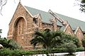
Holy Trinity Cathedral (Anglican Church)
-
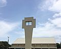
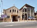
Christ the King Parish in Accra (Catholic Church)
-
All Saints church in Adabraka
-
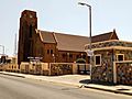
Accra Wesley Cathedral, one of Ghana's oldest churches.
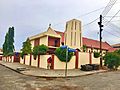
-
The St. Augustine Anglican Church in Dansoman.
-
Anglican Diocese of Accra — ST. Mary the Virgin Church.


Accra has many places of worship. Most are Christian churches, such as:
- Church of the Province of West Africa (Anglican)
- Presbyterian Church of Ghana
- Ghana Baptist Convention
- Lighthouse Chapel International
- Church of Pentecost
- Assemblies of God
- Roman Catholic Archdiocese of Accra (Catholic Church)
There are also Muslim mosques.
Important places of worship include the Holy Trinity Cathedral, Wesley Methodist Cathedral, the Ghana National Mosque, and the Accra Ghana Temple of The Church of Jesus Christ of Latter-day Saints.
Culture and Tourism

Tourism in Ghana is growing, with over a million international visitors in 2011. Accra is the main tourist spot in the Greater Accra region. It has many hotels, monuments, museums, and nightclubs. There are several five-star hotels, like the Labadi Beach Hotel. The Accra International Conference Centre hosts many meetings.
The Du Bois Centre has a research library and a gallery. It is also the burial place of scholar W.E.B. Du Bois and his wife. The Kwame Nkrumah Mausoleum is where Ghana's first President, Kwame Nkrumah, is buried. He led Ghana to independence and was a key figure in Pan-Africanism.
The National Theatre in Accra is home to the National Symphony Orchestra Ghana. It has a unique modern Chinese design.
The city's most historic area is Jamestown. It has the Ussher Fort and James Fort. Osu Castle (also known as Christiansborg) was built by Danish settlers in the 17th century.
Other important sites include the Jubilee House (the President's office), the Parliament House of Ghana, and the Black Star Square. The African Fashion Foundation in Accra supports the African fashion industry.
Accra has beaches along the Atlantic coast. The most popular are Labadi Beach and Kokrobite Beach. The Academy of African Music and Arts is also located near the beach.
Ghana's film industry is also growing. A documentary about climate change impacts, made by young Ghanaians, premiered in Accra in 2022.
Sister Cities
Accra has several official sister cities around the world:
| City | Province / Region / State | Nation | Year | Ref |
|---|---|---|---|---|
| Gauteng | ||||
| Sterling | Connecticut | |||
| District of Columbia | 2006 | |||
| Columbia | South Carolina | |||
| Columbus | Ohio | 2015 | ||
| Chattanooga | Tennessee | 2024 |
UNESCO World Book Capital
In October 2022, the United Nations Educational, Scientific and Cultural Organization (UNESCO) named Accra the World Book Capital for 2023.
See Also
 In Spanish: Acra para niños
Images for kids
-
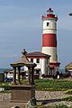
Jamestown Lighthouse
-
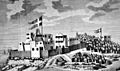
A drawing of Fort Christiansborg, now Osu Castle.
-
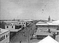
A main street of central Accra (1885-1908).
-
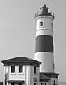
Jamestown Lighthouse in Jamestown/Usshertown.
-
Black Star Square.
-
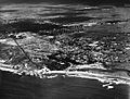
Aerial photograph of Accra (1929).
-
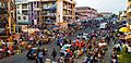
Accra Central.
-
PricewaterhouseCoopers building, Accra.
-
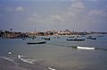
Fishing boats off the coast of Accra.
-
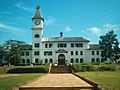
Achimota School.
-
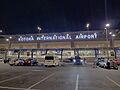
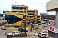
Kotoka International Airport Terminal 3.
-
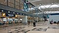
Terminal 3 Departure Hall.
-
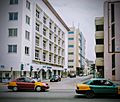
Taxis on Accra's High Street.
-

Ghana national football team (Black Stars) badge.
-
Holy Trinity Cathedral.
-
Christ the King Parish in Accra.
-
All Saints church in Adabraka.
-
Accra Wesley Cathedral.
-
The St. Augustine Anglican Church.
-
Anglican Diocese of Accra — ST. Mary the Virgin Church.
-
The Black Star Square in Accra.

_badge_and_national_anthem.jpg)
