
Gulf of Guinea facts for kids
.jpg)
 Earth's ocean, showing common divisions Earth's ocean, showing common divisions Earth's thermohaline circulation seawater flow Earth's thermohaline circulation seawater flow Map with five-oceans (approximate boundaries) Map with five-oceans (approximate boundaries) |
| Earth's ocean |
|---|
|
Main five oceans division: Further subdivision: Marginal seas |
The Gulf of Guinea is a large part of the Atlantic Ocean located off the west coast of Africa. It stretches from Cape Lopez in Gabon all the way north and west to Cape Palmas in Liberia.
This gulf is a special place because it's where the Equator (zero degrees latitude) and the Prime Meridian (zero degrees longitude) cross paths. Imagine a giant "X" on the map – that's where they meet in the Gulf of Guinea!
Many important rivers flow into this gulf. Two of the biggest are the Niger River and the Volta River. The coastline of the Gulf of Guinea also includes two large bays: the Bight of Benin and the Bight of Bonny.
Contents
Islands in the Gulf of Guinea
The Gulf of Guinea is home to several islands. The largest ones form a chain that runs from southwest to northeast. These islands are actually part of a group of volcanoes called the Cameroon line.
Annobón Island
Annobón is a small island that is part of Equatorial Guinea. It is also known by the names Pagalu or Pigalu.
Bioko Island
Bioko is a larger island located off the west coast of Africa. It is also part of Equatorial Guinea and sits right in the Gulf of Guinea.
Corisco Island
Corisco is another island that belongs to Equatorial Guinea. It is smaller than Bioko.
The Elobeys Islands
The Elobeys are two small islands named Elobey Grande and Elobey Chico. Both of these islands are also part of Equatorial Guinea.
São Tomé and Príncipe
São Tomé and Príncipe is a unique island nation in the Gulf of Guinea. Its official name is the Democratic Republic of São Tomé and Príncipe. People there speak Portuguese because it used to be a colony of Portugal. This country became independent in 1975.
More Pictures
-
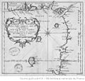
An old French map of the Gulf of Guinea from the 18th century.
-
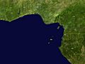
Satellite imagery of the Gulf of Guinea, showing the borders of the countries along its shores.


See also
 In Spanish: Golfo de Guinea para niños
