
Annobón facts for kids
Quick facts for kids
Annobón
|
||
|---|---|---|
|
||
 |
||
| Country | ||
| Capital | San Antonio de Palé | |
| Area | ||
| • Total | 17 km2 (7 sq mi) | |
| Population
(2015)
|
||
| • Total | 5,232 | |
| • Density | 308/km2 (797/sq mi) | |

|
Designations
|
|
| Official name: Isla de Annobón | |
| Designated: | 2 June 2003 |
|---|---|
| Reference #: | 1309 |
Annobón (Portuguese: Ano-Bom) is a province of Equatorial Guinea. It includes the island of Annobón and some smaller islands. These islands are located in the Gulf of Guinea and the Atlantic Ocean.
The main town and capital of Annobón is San Antonio de Palé. It is on the north side of the island. Another town is Mabana. Annobón has a safe place for ships to anchor. Ships sometimes stop there to get fresh water and supplies. However, there isn't a regular shipping service to the rest of Equatorial Guinea. Ships might only visit every few months.
In 2015, about 5,232 people lived on Annobón. This was a small increase from 5,008 people in 2001. The official language is Spanish. But most people speak a creole language based on Portuguese. The main jobs on the island are fishing and cutting timber.
Contents
What Does the Name Annobón Mean?
The name Annobón comes from the Portuguese words Ano Bom. This means "Good Year." The island was named this because Portuguese explorers found it on New Year's Day in 1473.
Later, during the time of Francisco Macías Nguema, the island was called Pigalu or Pagalu. These names came from the Portuguese word papagaio, which means "parrot."
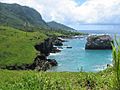
Where is Annobón Located?

.jpg)

Annobón is an extinct volcano. It is about 220 miles (350 km) west of Cape Lopez in Gabon. It is also about 110 miles (180 km) southwest of São Tomé Island. The main island is about 4 miles (6.4 km) long and 2 miles (3.2 km) wide. Its total area is about 6.75 square miles (17.5 square km).
Several small rocky islands surround Annobón. One of these is Santarém, to the south. The island has a crater lake called Lago A Pot. The highest point is Quioveo, which is 1,962 feet (598 meters) tall. Annobón has many green valleys and steep mountains. These areas are covered with thick forests and plants.
Even though Annobón is often said to be in the Gulf of Guinea, the official boundary line for the Gulf of Guinea is actually north of it.
A Brief History of Annobón
How Annobón Was Discovered
The Portuguese discovered Annobón on January 1, 1473. This is why it got its name, meaning "New Year." However, a Spanish explorer named Diego Ramirez de la Diaz first saw the island in 1470. He named it San Antonio.
The island was empty until the Portuguese started settling it in 1474. They brought people from Angola through São Tomé Island. These people were the first members of Annobonese society. Over time, some of these people married Europeans. Their children were called forros, meaning "slaves about to be free." The forros started to form their own unique culture and gained some power. This is also when the Annobonese Creole language began to develop.
Annobón Becomes Spanish
In 1778, the island was given to Spain through the Treaty of El Pardo. This treaty gave Spain control of Annobón and Fernando Po (now Bioko). It also gave Spain control of the coast between the Niger and Ogooué rivers. In return, Spain agreed that Portugal could keep lands in Brazil. This new Spanish colony later became known as Spanish Guinea.
The people of Annobón did not like this change. They were not friendly to the Spanish. When the Spanish flag was raised, the islanders protested. They thought the Spanish flag showed dogs, which they considered bad luck. (The flag actually showed lions.) They forced the Spanish to leave. For a while, the island was run by five local leaders. This self-governance continued until Spain took full control again later in the 1800s. The island was briefly part of the Elobey, Annobón and Corisco colony until 1909.
British Presence and Later Challenges
The British built a fort in "St Antony" in 1801. This was made legal in 1827 when they leased the land from Spain. The British used this base to stop the Atlantic slave trade.
During the last years of Francisco Macías Nguema's rule, the first president of Equatorial Guinea, the island was called Pigalu or Pagalu. The people of Annobón felt treated unfairly by the government of Equatorial Guinea. Some even wanted to separate and form their own country. In 1993, the government cut off the island from the outside world. They even made humanitarian groups leave. The people rebelled and attacked the governor's house. The government responded with unfair punishments. But international pressure helped ease the situation, and political prisoners were set free.
Because of Annobón, Equatorial Guinea asked to be an observer in the Community of Portuguese Language Countries in 1996. This group helps countries that speak Portuguese. In 2006, Equatorial Guinea became an observer. With support from Portuguese-speaking African countries, it became a full member in 2014. The Portuguese language was made an official language again in Equatorial Guinea.
Plants and Animals of Annobón
Unique Wildlife
Annobón was originally an empty island with many different kinds of plants and animals. When people came, they used small boats called "cayucos" to hunt humpback whales and other sea creatures near the island.
Today, Annobón has special birds found nowhere else. These include the Annobón white-eye and the Annobón paradise flycatcher. The São Tomé Island pigeon is also found here. There are 29 types of birds on the island. There are also two types of bats, with one found only on Annobón.
The island has five types of reptiles that are unique to it. These include one snake, three geckos, and two types of lizards. Three kinds of sea turtles visit the island. In the rivers, there are 18 types of fish, with one found only here. You can also find mosquitoes, scorpions, and large centipedes. Animals brought by people include fish, guinea fowl, rats, dogs, and cats. Annobón does not have any natural predators that are mammals. Sharks live in the sea around the island.
Rich Plant Life
Annobón has 208 types of vascular plants. About 15% of these plants are found only on the island. These include the "point up" baobab trees and ceiba trees. Ceiba wood is used to make cayuco boats. You can also find ficus trees, ferns, tree ferns, and large amounts of moss.
Images for kids
-
Annobón in 2011

See also
 In Spanish: Provincia de Annobón para niños
