
Equatorial Guinea facts for kids
Quick facts for kids
Republic of Equatorial Guinea
|
|
|---|---|
 Coat of arms
|
|
|
Anthem: Caminemos pisando las sendas de nuestra inmensa felicidad (Spanish)
Let Us Walk Treading the Paths of Our Immense Happiness |
|
 Show globe Show globe Show map of Africa Show map of Africa |
|
| Capital | Malabo (current) Ciudad de la Paz (under construction) 3°45′N 8°47′E / 3.750°N 8.783°E |
| Largest city | Malabo, Bata |
| Official languages |
|
| Recognised regional languages |
List
|
| Ethnic groups
(2020)
|
|
| Religion
(2020)
|
|
| Demonym(s) |
|
| Government | Unitary dominant-party presidential republic under a totalitarian dictatorship |
| Teodoro Obiang Nguema Mbasogo | |
| Teodoro Nguema Obiang Mangue | |
| Manuel Osa Nsue Nsua | |
| Legislature | Parliament |
| Senate | |
| Chamber of Deputies | |
| Independence
from Spain
|
|
|
• Declared
|
12 October 1968 |
| Area | |
|
• Total
|
28,050 km2 (10,830 sq mi) (141st) |
|
• Water (%)
|
negligible |
| Population | |
|
• 2024 estimate
|
1,795,834 (154th) |
| GDP (PPP) | 2023 estimate |
|
• Total
|
|
|
• Per capita
|
|
| GDP (nominal) | 2023 estimate |
|
• Total
|
|
|
• Per capita
|
|
| HDI (2022) | medium · 133rd |
| Currency | Central African CFA franc (XAF) |
| Time zone | UTC+1 (WAT) |
| Date format | dd/mm/yyyy |
| Driving side | right |
| Calling code | +240 |
| ISO 3166 code | GQ |
| Internet TLD | .gq |
|
|

Equatorial Guinea, officially known as the Republic of Equatorial Guinea, is a country located on the west coast of Central Africa. It covers an area of about 28,000 square kilometres (11,000 sq mi). The country was once a colony of Spanish Guinea. Its name comes from its location near the Equator and the African region of Guinea.
As of 2024, Equatorial Guinea has a population of about 1.8 million people. More than 85% of the people belong to the Fang people, which is the main ethnic group. The Bubi people, who are native to Bioko island, are the second largest group. They make up about 6.5% of the population.
Equatorial Guinea has two main parts: an island region and a mainland region. The island region includes Bioko (once called Fernando Pó) in the Gulf of Guinea. It also has Annobón, a small volcanic island south of the equator. Bioko Island is the northernmost part of the country. It is home to the capital city, Malabo. The Portuguese-speaking island nation of São Tomé and Príncipe is located between Bioko and Annobón.
The mainland region, called Río Muni, shares borders with Cameroon to the north and Gabon to the south and east. Here you will find Bata, the second largest city. Ciudad de la Paz is also on the mainland. It is being built to become the country's future capital. Río Muni also has small islands nearby, like Corisco, Elobey Grande, and Elobey Chico. Equatorial Guinea is a member of important groups like the African Union and OPEC.
After gaining independence from Spain in 1968, Equatorial Guinea was led by Francisco Macías Nguema. He was later overthrown in 1979 by his nephew, Teodoro Obiang Nguema Mbasogo. Obiang has been the country's president ever since. Since the mid-1990s, Equatorial Guinea has become a major oil producer in sub-Saharan Africa. This has made it one of the richest countries per person in Africa. However, this wealth is not shared equally among everyone.
Spanish is the main official language because Equatorial Guinea was a Spanish colony. French and Portuguese are also official languages. However, they are not used as widely as Spanish.
Contents
Exploring Equatorial Guinea's Past
The first people to live in the mainland area of Equatorial Guinea were likely Pygmies. Today, only small groups of them remain in southern Río Muni. Later, Bantu people moved into the area around 500 BC. The first settlements on Bioko Island date back to AD 530. The people of Annobón originally came from Angola. They were brought there by the Portuguese.
First European Visitors and Portuguese Control (1472–1778)
.jpg)
In 1472, the Portuguese explorer Fernão do Pó was the first European to see Bioko island. He named it Formosa, meaning "Beautiful." But it soon became known by his name. Portugal took control of Fernando Pó and Annobón in 1474. They tried to start a sugarcane farm on Fernando Pó around 1500. However, this failed because of local resistance and diseases. The island's wet climate and high humidity made it hard for European settlers.
Early Spanish Rule and British Lease (1778–1844)

In 1778, Portugal gave Bioko and nearby islands to Spain. This was part of the Treaty of El Pardo. In return, Spain gave Portugal large areas in South America. Spain faced difficulties in its new colony, including disease and a crew mutiny. Despite this, Spaniards began using the island for slave trading. From 1778 to 1810, the area was managed from Buenos Aires.
Spain did not want to spend much on Fernando Pó. So, from 1827 to 1843, they leased a base on Bioko to the United Kingdom. The British used this base to help stop the Atlantic slave trade. Spain agreed to abolish slavery in 1817, which made the colony seem less valuable. An agreement for Spain to sell the colony to the British was canceled in 1841.
The Late 1800s (1844–1900)
_Golfo_de_Guinea.jpg)
In 1844, the British returned the island to Spain. The area was then called "Territorios Españoles del Golfo de Guinea." Spain did not invest much due to epidemics. In 1862, a yellow fever outbreak killed many European settlers. Despite this, private citizens continued to set up plantations.
Plantations on Fernando Pó were mostly run by a black Creole elite, known as Fernandinos. Many of these were freed slaves from Sierra Leone and other parts of West Africa. They became traders and helped connect locals with Europeans. William Pratt, a freed slave, helped start cocoa farming on Fernando Pó.
The Early 1900s (1900–1945)

Spain had not fully taken control of all the land it claimed in the Bight of Biafra. France had expanded its own territory. The Treaty of Paris in 1900 left Spain with the mainland area of Río Muni. This was much smaller than what Spain had originally claimed.
Rules for land ownership in 1904–1905 favored Spaniards. An agreement was made with Liberia in 1914 to bring in workers. However, this agreement ended in 1930 due to bad practices. After this, plantation owners on Fernando Pó turned to Río Muni for workers. The Fang people were brought under control in the 1920s. By 1929, the entire colony was considered 'pacified'.

By the late 1800s, Claretian missionaries protected the Bubi people from plantation demands. The Bubi were disarmed in 1917. They became dependent on the missionaries. A temporary solution to labor shortages came from refugees and soldiers from German Kamerun.
Between 1926 and 1959, Bioko and Río Muni were combined as the colony of Spanish Guinea. The economy relied on large cacao and coffee farms and logging. Most workers were immigrants from Liberia, Nigeria, and Cameroun.
_(1941)_(5811105541).jpg)
The Spanish Civil War also affected the colony. Nationalist forces took control of Río Muni in September 1936. This secured Equatorial Guinea for Francisco Franco. Río Muni suffered from labor shortages. Many Igbo from Nigeria were brought in. This helped Fernando Pó become a very productive farming area after World War II.
The Road to Independence (1945–1968)

After World War II, the colony's status changed. In 1959, it became a "province" of Spain. From 1960 to 1968, Spain tried to give the territory some self-rule. This was meant to keep it connected to Spain. However, by the late 1960s, many African countries were gaining independence. Spain began preparing Equatorial Guinea for independence.
The country's wealth per person was high in 1965. Spain built an international airport and a television station. They also improved literacy rates. In 1967, Equatorial Guinea had more hospital beds per person than Spain.

In 1963, the territory gained some self-rule. But the United Nations pushed for full independence. In 1965, the UN passed resolutions telling Spain to grant independence. In 1966, a UN team visited the country and recommended independence. Spain then announced a meeting in 1967 to create a new constitution. The main groups were the Fernandinos and Bubi, who feared losing power, and the Fang nationalists. The leading Fang figure, Francisco Macías Nguema, made a controversial speech. The conference faced disagreements. Macías went to the UN to gain international support. This led Spain to set a date for independence and elections.
Independence Under Macías (1968–1979)

Equatorial Guinea became independent from Spain on 12 October 1968. The new country was named the Republic of Equatorial Guinea. This day is celebrated as the country's Independence Day. Macías became president after the country's only free and fair election. Spain had supported Macías.
During the Nigerian Civil War, many Biafran workers and refugees were on Fernando Pó. The International Committee of the Red Cross tried to send aid flights from Equatorial Guinea. But Macías stopped these flights.
Macías Nguema became a very powerful leader. He outlawed other political parties in 1970. In 1972, he declared himself president for life. He cut ties with Spain and Western countries. Equatorial Guinea developed special relationships with communist countries like China, Cuba, and the USSR. The Soviet Union gained access to a naval base at Luba.
By 1974, many people had been killed. A quarter of the population fled the country. Prisons were full. It is estimated that 80,000 people died out of a population of 300,000. Macías Nguema ordered the deaths of many suspected opponents. He closed churches and the economy collapsed.
Obiang's Leadership (1979–Present)

Teodoro Obiang, Macías Nguema's nephew, overthrew his uncle on 3 August 1979. Macías Nguema was captured, tried, and executed. Obiang then became president.
In 1995, an American oil company, Mobil, found oil in Equatorial Guinea. The country's economy grew very quickly. However, the money from oil has not reached most of the people. Many still lack access to clean drinking water. President Teodoro Obiang is believed to use the country's oil wealth for himself and his friends.
In 2011, the government announced plans for a new capital city called Oyala. The city was renamed Ciudad de la Paz ("City of Peace") in 2017.
As of As of February 2016[update], Obiang is one of Africa's longest-serving leaders. Equatorial Guinea was a temporary member of the United Nations Security Council from 2018 to 2019. In November 2022, Obiang was re-elected president.
Discovering Equatorial Guinea's Geography
Equatorial Guinea is located on the west coast of Central Africa. It has a mainland area, Río Muni. This part is bordered by Cameroon to the north and Gabon to the east and south. The country also includes five small islands: Bioko, Corisco, Annobón, Elobey Chico (Small Elobey), and Elobey Grande (Great Elobey). Bioko, where the capital Malabo is, lies about 40 kilometers (25 mi) off the coast of Cameroon. Annobón Island is about 350 kilometers (220 mi) west-south-west of Cape Lopez in Gabon. Corisco and the two Elobey islands are in Corisco Bay, near the border of Río Muni and Gabon.
Equatorial Guinea is located between 4°N and 2°S latitude. It is also between 5° and 12°E longitude. Even though it's called "Equatorial" Guinea, most of the country is in the Northern Hemisphere. Only the island of Annobón Province is south of the equator.
Climate and Weather Patterns

Equatorial Guinea has a tropical climate. It has clear wet and dry seasons. From June to August, Río Muni is dry, while Bioko is wet. From December to February, the opposite happens. Annobón has rain or mist every day. A day without clouds has never been recorded there.
Temperatures in Malabo, Bioko, range from 16 °C (61 °F) to 33 °C (91 °F). On the Moka Plateau in the south, high temperatures are around 21 °C (70 °F). In Río Muni, the average temperature is about 27 °C (81 °F). Annual rainfall varies greatly. Malabo gets about 1,930 mm (76 in) of rain. Ureka, Bioko, gets up to 10,920 mm (430 in). Río Muni is a bit drier.
Nature and Wildlife
.svg)
Equatorial Guinea has many different natural areas. The Río Muni region is covered by Atlantic Equatorial coastal forests. There are also patches of Central African mangroves along the coast. The Cross-Sanaga-Bioko coastal forests cover most of Bioko. The Mount Cameroon and Bioko montane forests are found in the highlands of Bioko. Annobón is part of the São Tomé, Príncipe, and Annobón moist lowland forests region.
In 2018, the country had a high score for its natural forest areas. This ranked it 30th globally out of 172 countries.
- Nature in Equatorial Guinea
-
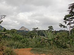
Near Ciudad de la Paz


Amazing Wildlife
Equatorial Guinea is home to many animals. You can find gorillas, chimpanzees, and various monkeys. There are also leopards, buffalo, antelope, elephants, hippopotamuses, and crocodiles. Different types of snakes, including pythons, also live here.
- Wildlife of Equatorial Guinea
-
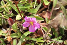
Dissotis
-
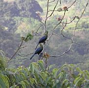
Yellow-billed turaco


How Equatorial Guinea is Divided
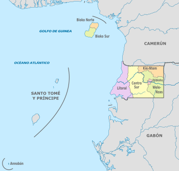
Equatorial Guinea is divided into eight provinces. The newest province is Djibloho. It was created in 2017. Its main office is in Ciudad de la Paz, the future capital. The eight provinces are:
- Annobón (San Antonio de Palé)
- Bioko Norte (Malabo)
- Bioko Sur (Luba)
- Centro Sur (Evinayong)
- Djibloho (Ciudad de la Paz)
- Kié-Ntem (Ebebiyín)
- Litoral (Bata)
- Wele-Nzas (Mongomo)
These provinces are further divided into 19 districts and 37 municipalities.
Understanding Equatorial Guinea's Economy
.svg)
Before gaining independence, Equatorial Guinea exported cocoa, coffee, and timber. These products mostly went to Spain, its colonial ruler. On 1 January 1985, the country joined the franc zone. It adopted the CFA franc as its money. Before this, its money, the ekwele, was linked to the Spanish peseta.

In 1996, large oil reserves were found. This led to a huge increase in government money. As of As of 2004[update], Equatorial Guinea was the third-largest oil producer in Sub-Saharan Africa. Oil companies like ExxonMobil and Marathon Oil operate there.
Forestry, farming, and fishing are also important parts of the country's economy. Most farming is for people to feed themselves. Agriculture provides jobs for 57% of rural families. From 2000 to 2010, Equatorial Guinea had the highest average yearly increase in its gross domestic product (GDP).
Equatorial Guinea is a member of the Central African Monetary and Economic Union (CEMAC). This group includes over 50 million people.

According to the World Bank, Equatorial Guinea has the highest gross national income (GNI) per person in Africa. However, there is a lot of poverty. This is because wealth is not shared equally. In 2019, 70% of the population lived on about one dollar a day. The country ranks 145th out of 189 on the United Nations Human Development Index.
Oil and gas make up 97% of the country's exports. The economy has faced challenges, partly due to corruption. In 2022, the country's economy was expected to shrink by about 4.4%.
Getting Around: Transportation


Because of the large oil industry, many international airlines fly to Malabo International Airport. In May 2014, this airport had direct flights to Europe and West Africa. Equatorial Guinea has three airports: Malabo International Airport, Bata Airport, and the Annobón Airport. Malabo International Airport is the only one for international travel.
Airlines registered in Equatorial Guinea are not allowed to fly in the European Union (EU). However, cargo planes still fly from European cities to the capital.
People and Population

| Year | Million |
|---|---|
| 1950 | 0.2 |
| 2000 | 0.6 |
| 2020 | 1.4 |
Most people in Equatorial Guinea are of Bantu origin. The largest group is the Fang. They are native to the mainland. However, many Fang people have moved to Bioko Island. So, their population there is now larger than the original Bubi inhabitants. The Fang make up 80% of the population. They have about 67 different clans.
Coastal ethnic groups are sometimes called Ndowe or "Playeros" (Beach People). These include the Combes, Bujebas, Balengues, and Bengas. They live on the mainland and small islands. The Fernandinos, a Krio community, live on Bioko Island. These groups together make up 5% of the population. Most ethnic Spaniards left after independence.

More and more foreigners from nearby countries like Cameroon, Nigeria, and Gabon have moved to Equatorial Guinea. Some Igbo from Nigeria also live on Bioko island. People from other parts of Africa and Asia came to work on cocoa and coffee farms. Most of the Asian population is Chinese.
Languages Spoken in Equatorial Guinea
.jpg)
Since its independence in 1968, Spanish has been the main official language. It helps different ethnic groups communicate. In 1970, during Macías' rule, Fang became the official language. This was changed back in 1979. Spanish was the only official language until 1998. Then, French was added as a second official language. This happened because the country joined a group of French-speaking nations. Portuguese became the third official language in 2010.
Spanish has been an official language since 1844. It is still used in schools and government. About 67.6% of people can speak Spanish, especially in the capital, Malabo. French is not widely spoken locally. It was made official mainly to join the Francophonie.

Local languages are important to the "national culture." These include Fang, Bube, Benga, and others. Most African ethnic groups speak Bantu languages.
Fa d'Ambô, a Portuguese creole language, is used in Annobón Province. Many people on Bioko can also speak Spanish. Pichinglis, an English-based creole, is also used for trade.
In 2010, the government added Portuguese as an official language. This was to improve communication and trade with Portuguese-speaking countries. It also recognized historical ties with Portugal.
Equatorial Guinea wanted to join the Community of Portuguese Language Countries (CPLP). This would give them access to exchange programs. Adopting Portuguese was a main requirement. The country also needed to make political reforms and respect human rights. In July 2014, Equatorial Guinea was accepted as a CPLP member.
Religion in Equatorial Guinea
| Religion in Equatorial Guinea | ||||
|---|---|---|---|---|
| Religion | per cent | |||
| Roman Catholic | 88% | |||
| Other (indigenous beliefs / Baháʼí) | 5% | |||
| Protestant | 5% | |||
| Muslim | 2% | |||

The main religion in Equatorial Guinea is Christianity. About 93% of the people are Christian. Most Christians are Roman Catholics (88%). A smaller number are Protestants (5%). About 2% of the population follows Islam. The remaining 5% practice Animism, Baháʼí, and other beliefs. Traditional animist beliefs are often mixed with Catholicism.
Health and Well-being
Equatorial Guinea has made progress in reducing malaria. Their programs include spraying homes twice a year. They also use special medicines and mosquito nets. These efforts led to a 64% drop in deaths of children under five.
In June 2014, four cases of polio were reported. This was the country's first outbreak of the disease.
Learning and Education
_(6510104101).jpg)
Equatorial Guinea has one of the highest literacy rates in sub-Saharan Africa. As of as of 2015[update], 95.3% of people aged 15 and over could read and write. Under President Obiang, the number of primary school students increased greatly. Education is free and required for children aged 6 to 14.
The government has partnered with companies to improve teacher training. There are now 51 model schools. These schools use modern teaching methods.
The country has one university, the Universidad Nacional de Guinea Ecuatorial (UNGE). It has a campus in Malabo. There is also a Faculty of Medicine in Bata. This medical school is supported by the government of Cuba.
Culture and Lifestyle

In June 1984, the First Hispanic-African Cultural Congress was held. It explored the cultural identity of Equatorial Guinea.
Tourism and Attractions
.jpg)
As of As of 2020[update], Equatorial Guinea does not have any UNESCO World Heritage Sites.
Tourist attractions include the old colonial area in Malabo. In southern Bioko island, you can hike to the Iladyi cascades. You can also visit remote beaches to watch nesting turtles. Bata has a nice shoreline walk called Paseo Maritimo. Mongomo has the basilica, which is the second largest Catholic church in Africa. The new capital, Ciudad de la Paz, is also a place to visit.
Media and Communication
.jpg)
The main ways to get information are three state-run FM radio stations. International stations like BBC World Service also broadcast there. There is also an independent online radio called Radio Macuto. It is known for reporting news about Obiang's government. There are five shortwave radio stations.
Televisión de Guinea Ecuatorial is the state-run television network. Its international program is available worldwide online. There are also two newspapers and two magazines.
Equatorial Guinea ranks low in press freedom. The state-owned media follows government orders. Most media companies avoid criticizing public figures. The president's son directs the state-owned media.
Few people have landline telephones. There is one mobile phone company, Orange. It covers Malabo, Bata, and some mainland cities. As of As of 2009[update], about 40% of the population had mobile phones. By 2022, over a million people used the Internet.
Music and Arts
Popular music styles include Pan-African sounds like soukous and makossa. Reggaeton, Latin trap, reggae, and rock and roll are also enjoyed.
Cinema and Films
In 2014, the drama film Where the Road Runs Out was filmed in the country. There is also a documentary called The Writer from a Country Without Bookstores. This film openly criticizes Obiang's government.
Sports and Athletics
.jpg)
Equatorial Guinea co-hosted the 2012 African Cup of Nations with Gabon. It also hosted the 2015 edition alone. The country hosted and won the 2008 Women's African Football Championship. The women's national team played in the 2011 FIFA Women's World Cup in Germany. In June 2016, Equatorial Guinea was chosen to host the 2019 African Games.
Equatorial Guinea is known for swimmers Eric Moussambani, called "Eric the Eel," and Paula Barila Bolopa, "Paula the Crawler." They both competed in the 2000 Summer Olympics.
Basketball has become more popular in the country.
National Public Holidays and Cultural Festivals
- Independence Day: This is the most important national holiday. It commemorates the country's independence from Spain in 1968. The capital, Malabo, is the center of the festivities. The national flag is displayed prominently everywhere.
- Armed Forces Day (August 3): A day to honor the country's military forces. Features a major military parade in Malabo, showcasing troops, vehicles, and equipment. It's a day of national pride and display of state power.
- Constitution Day (August 15): Celebrates the adoption of the country's constitution. Lower-key than Independence Day, it is marked by official ceremonies and reflections on the nation's governance.
Religious Holidays
As a predominantly Catholic country, Equatorial Guinea celebrates:
- Christmas (December 25): Celebrated with church services, family feasts, and gift-giving.
- Good Friday and Easter Sunday: Solemn religious processions and joyful celebrations.
- Immaculate Conception (December 8): A public holiday with religious observances.
Cultural and Local Festivals
- Aban-Abana (Malabo Sea Festival): A relatively new festival aimed at promoting tourism, featuring boat races, traditional music, dance, and seafood.
- Traditional Fang and Bubi Festivals: These often involve rituals, masks, music, and dance that have been passed down for generations. They are more common in villages and rural areas and are often tied to harvests, initiations, or other community milestones.
See also
 In Spanish: Guinea Ecuatorial para niños
