
Treaty of Paris (1900) facts for kids
|
27 June 1900 |
|
| Type | Bilateral treaty |
|---|---|
| Signed | 27 June 1900 |
| Location | Paris, France |
| Original signatories |
|
| Ratifiers |
|
.svg)
.svg)
The Treaty of Paris was an important agreement signed on June 27, 1900. It was made between two countries: Spain and France. This treaty helped draw the lines (or borders) for their colonies in Africa. It decided which parts of the Sahara desert (like a place called Río de Oro) and Equatorial Africa (like Spanish Guinea) belonged to Spain and which belonged to France.
How the Treaty Changed Things
The Treaty of Paris settled arguments over land in Africa. Spain had claimed a very large area, about 300,000 square kilometers. This land stretched all the way to the Ubangi River.
However, after the treaty, Spain was left with a much smaller area. They only kept about 26,000 square kilometers. This meant France gained a lot of territory.
The treaty also had a special rule. If Spain ever decided to give up its land in Río Muni, France would have the first chance to take it. This showed how much power France had in the agreement.
Maps of the Area
-
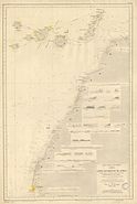
This map from 1896 shows the coast of Río de Oro before the treaty.
-
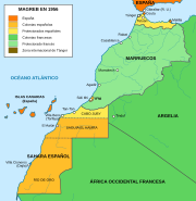
This map shows the borders of Spanish territories after the 1900 treaty. It includes Río de Oro within Spanish Sahara.
-
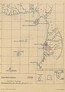
This map from 1897 shows Spanish lands in the Gulf of Guinea before the Treaty of Paris.
-
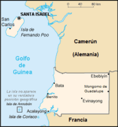
This map shows the new borders after the 1900 agreement. This land later became Spanish Guinea, which is now Equatorial Guinea.

.svg)
_Golfo_de_Guinea.jpg)

See Also
