Bight of Biafra facts for kids
Quick facts for kids Bight of Biafra |
|
|---|---|

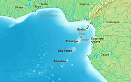
Gulf of Guinea map showing the Bight of Biafra.
|
|
| Coordinates | 2°50′N 8°0′E / 2.833°N 8.000°E |
| Native name | Golfo de Biafra (Portuguese) |
| River sources | Niger |
| Ocean/sea sources | Gulf of Guinea Atlantic Ocean |
| Basin countries | Nigeria, Cameroon, Equatorial Guinea, Gabon |
| Max. length | 300 km (190 mi) |
| Max. width | 600 km (370 mi) |
| Islands | Bioko |
The Bight of Biafra is a large bay located off the west-central coast of Africa. It's the easternmost part of the Gulf of Guinea. In Nigeria, this bay is also known as the Bight of Bonny. It's a significant part of the Atlantic Ocean.
Contents
Geography of the Bight of Biafra
A bight is a large curve or bend in a coastline, forming a wide open bay. The Bight of Biafra stretches from Cape Formosa to Cape Lopez. It is the most eastern part of the Gulf of Guinea.
The Bight of Biafra extends east from the Niger Delta of the Niger River in the north. It reaches all the way to Cape Lopez in Gabon. Many rivers flow into this bay. Besides the Niger River, important rivers include the Cross River, Calabar River, Wouri, and Sanaga.
The main islands in the bay are Bioko and Príncipe. Other important islands include Ilhéu Bom Bom and Elobey Grande. The countries that border the Bight of Biafra are Cameroon, Nigeria, Equatorial Guinea, and Gabon.
History of the Bight of Biafra
The Bight of Biafra played a big role in history. From the 1500s to the 1800s, it was a major area for the transatlantic slave trade. Many people were taken from this region and forced into slavery in the Americas.
- Between 1519 and 1700, about 10.7% of all enslaved people sent to the Americas came from here.
- From 1701 to 1800, this number grew to about 14.97%.
- People from groups like the Igbo, Fang, and Bubi were among those taken.
By the mid-1700s, Bonny became the most important port for slave trading in the Bight of Biafra. Other major ports were Elem Kalabari and Old Calabar. Together, these three ports handled over 90% of the slave trade from this area.
Between 1525 and 1859, Britain was responsible for over two-thirds of the enslaved people sent from the Bight of Biafra to the New World.
Efforts to Stop the Slave Trade
In 1777, Portugal gave control of Fernando Po and Annobón islands to Spain. This brought Spain into the early colonial history of the Bight of Biafra.
In 1807, the United Kingdom made the international slave trade illegal. The Royal Navy was sent to stop ships from various countries that were still involved in this trade.
Britain also set up a naval base and consulate on Fernando Po island in 1849. This helped them to enforce the ban on slave trading. British Consuls were in charge of this area.
- From 1861, the Bight of Biafra and the nearby Bight of Benin were united under one British consulate. Famous explorers like Richard Francis Burton served as consuls here.
Name Change and Modern History
In 1967, the eastern part of Nigeria decided to become its own country. It took the name Republic of Biafra, named after the coastline. However, this new country did not last long. It lost the Nigerian Civil War that followed.
In 1975, the Nigerian government officially changed the name of the Bight of Biafra to the Bight of Bonny.
Earth's Pulse in the Bight of Bonny
Did you know the Earth has a "pulse"? In 1962, a geologist named Jack Oliver noticed that the Earth makes a tiny, regular vibration. This is called a "microseism" in geology.
Scientists later found that the Earth pulses about every 26 seconds. No one is completely sure why this happens. Some ideas include ocean waves hitting the continental shelf or volcanic activity.
Using special methods, scientists were able to find the source of this mysterious pulse. It comes from the Bight of Bonny, which is the same as the Bight of Biafra!
See also
 In Spanish: Golfo de Biafra para niños
 | Toni Morrison |
 | Barack Obama |
 | Martin Luther King Jr. |
 | Ralph Bunche |


