
Drainage basin facts for kids
A drainage basin is a special area of land. It's all about how water flows into rivers. You might also hear it called a river basin or catchment area.
Imagine rain falling on a huge piece of land. All that water, whether it's from rain or melting snow, will eventually flow into one main river. Sometimes, smaller rivers called tributaries join the main river first. Think of them as branches feeding into a tree trunk.
Some drainage basins are enormous! For example, the Mississippi River and its tributaries drain more than half of the United States. The Amazon basin in South America is another giant example.
A river basin is like an open system. Water enters as precipitation (rain or snow). It then leaves the basin as discharge, which is the water flowing out of the main river.
What is a Watershed?
The word "watershed" can have two main meanings:
- It can mean a drainage divide. This is like an imaginary line on high ground. It separates one drainage basin from another. Water on one side flows into one river, and water on the other side flows into a different river.
- In North America, "watershed" often means the same thing as a drainage basin. It describes the whole area of land where surface water collects and flows into a single river system.
Related Topics
Images for kids
-
A digital map showing the Latorița River's drainage basin in Romania.
-
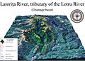
A 3D model of the Latorița River's drainage basin in Romania.
-
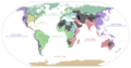
This map shows how water from different land areas flows into the oceans. The grey areas are endorheic basins, which means their water doesn't reach the ocean.
-
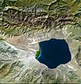
An Endorheic basin in Central Asia. Its water stays within the basin and doesn't flow to the sea.
-
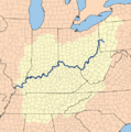
The drainage basin of the Ohio River. This river is a big part of the larger Mississippi River drainage basin.
-
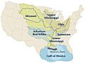
The Mississippi River drains the largest area of any river in the United States. Much of this land is used for farming. Water pollution from these areas can cause a "dead zone" in the Gulf of Mexico.


See also
 In Spanish: Cuenca hidrográfica para niños
