
Sanaga River facts for kids
Quick facts for kids Sanaga River |
|
|---|---|

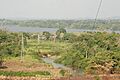
The Sanaga River after the Edea Hydroelectric Power Station
|
|

Map of the Sanaga River drainage basin
|
|
| Country | Cameroon |
| Regions | East Region, Centre Region, Littoral Region |
| Cities | Edéa, Nanga Eboko, Bélabo |
| Physical characteristics | |
| Main source | Confluence of Djérem River and Lom River 628 m (2,060 ft) 5°19′26″N 13°23′52″E / 5.323772°N 13.397769°E |
| River mouth | Bight of Biafra 0 m 3°33′34″N 9°39′08″E / 3.559338°N 9.652175°E |
| Length | 603 km (375 mi), with Djérem River 1,067.5 km (663.3 mi) |
| Discharge (location 2) |
|
| Basin features | |
| River system | Sanaga River |
| Basin size | 132,990 km2 (51,350 sq mi) |
| Tributaries |
|
| Waterbodies | Song Loulou Hydroelectric Power Station, Edea Hydroelectric Power Station |
| Bridges | Japoma Bridge |
The Sanaga River is the biggest river in Cameroon. It flows through the East, Centre, and Littoral parts of the country. Its main part is about 603 km (375 mi) long. This length is measured from where the Djérem and Lom Rivers join.
If you include the Djérem River, which is its longest source, the whole Sanaga-Djérem river system is about 1,067.5 km (663.3 mi) long. The Djérem River itself stretches for 464.5 km (288.6 mi).
Contents
Where the Sanaga River Starts and Flows
The Sanaga River begins high up on the Adamawa Plateau. It forms when two other rivers, the Djérem and the Lom River, meet. This meeting point is in the northern part of the East Region.
The Djérem River is about 464.5 km (288.6 mi) long. The Lom River is a bit shorter, at about 424.2 km (263.6 mi). Besides these two starting rivers, the biggest river that flows into the Sanaga is the Mbam River. The Mbam River is about 548 km (341 mi) long.

Climate and Forests Around the Sanaga River
The Sanaga River acts like a natural border. It separates two different types of tropical moist forests. These are special areas called ecoregions.
To the north of the Sanaga River, you'll find the Cross-Sanaga-Bioko coastal forests. These forests stretch between the Sanaga River and the Cross River in Nigeria. South of the Sanaga River, the Atlantic Equatorial coastal forests begin. These forests spread through southwestern Cameroon and into other countries like Equatorial Guinea, Gabon, the Republic of the Congo, Cabinda, and the Democratic Republic of the Congo.
How Much Water the Sanaga River Carries
Scientists measure how much water flows in the Sanaga River. This is called its flow or discharge. They measure it in cubic meters per second (m³/s). Here's how much water was measured flowing through the river at Edéa each month:
Dams and Reservoirs on the Sanaga River
There are two important dams built on the Sanaga River. Dams help control the river's flow and can be used to create electricity.
| Dam | Power it can make (MW) |
Reservoir | Water surface area (km2) |
Total water it can hold (Mio. m³) |
|---|---|---|---|---|
| Song Loulou | 384 | 10 | ||
| Edea | 264 |
Bridges Over the Sanaga River
The Sanaga River is crossed by bridges that help people and goods move around.

- The Camrail railway has a bridge that crosses the Sanaga River near the city of Edea.
Images for kids
-
Forests grow all around the Sanaga River.
-
Another view of the area near the Sanaga River.


