
Ciudad de la Paz facts for kids
Quick facts for kids
Ciudad de la Paz
|
|
|---|---|
|
Urban district
|
|

Ciudad de la Paz
Location in Equatorial Guinea

Ciudad de la Paz
Location in Equatorial Guinea

Ciudad de la Paz
Location in Africa
|
|
| Country | |
| Province | Djibloho |
| Region | Río Muni |
| Area | |
| • Total | 81.5 km2 (31.5 sq mi) |
| Elevation | 454 m (1,490 ft) |
| Population
(2022)
|
|
| • Total | 2,000 |
| • Density | 25/km2 (64/sq mi) |
| Time zone | WAT |
| Climate | Am/As |
Ciudad de la Paz (which means "City of Peace" in Spanish) is a brand new city being built in Equatorial Guinea. It used to be called Oyala. This city is planned to become the new capital of the country. It will replace the current capital, Malabo.
The city started as an urban district in 2015. In 2017, it became the main office for Djibloho, Equatorial Guinea's newest province. Ciudad de la Paz is located near the town of Mengomeyén. Its location was chosen because it's easy to get to and has good weather. Unlike Malabo, which is on an island, Ciudad de la Paz is on the mainland.
The city was designed by a Portuguese architecture company. It is expected to have about 200,000 people living there. Plans include a new Parliament building and many homes for the president. The city will cover a large area of 81.5 square kilometers. Some people have criticized building this new capital. However, the government of Equatorial Guinea started moving into the city in early 2017.
Contents
Where is Ciudad de la Paz Located?
Its Spot in Equatorial Guinea
Ciudad de la Paz is located near the center of Río Muni. This is the mainland part of Equatorial Guinea. It sits between the cities of Bata and Mongomo. The city is also just 20 kilometers from the Mengomeyén airport. The city gets its electricity from the 120 MW Djibloho Dam. This dam is in the Djibloho Evinayong district.
What is the Climate Like?
Ciudad de la Paz has a tropical climate. This means it's usually warm and wet. It gets a lot of rain, about 2142 millimeters each year. This rain helps the rainforests in the area grow.
The city has a long wet season that lasts for 10 months, from September to June. There's a short, slightly cooler dry season in July and August. Even in December and January, it's still wet, but a bit drier than other months. Temperatures stay very warm all year. This is normal for places close to the equator.
| Climate data for Ciudad de la Paz | |||||||||||||
|---|---|---|---|---|---|---|---|---|---|---|---|---|---|
| Month | Jan | Feb | Mar | Apr | May | Jun | Jul | Aug | Sep | Oct | Nov | Dec | Year |
| Mean daily maximum °C (°F) | 27.7 (81.9) |
28.2 (82.8) |
28.4 (83.1) |
28.2 (82.8) |
27.8 (82.0) |
26.4 (79.5) |
25.2 (77.4) |
25.6 (78.1) |
26.3 (79.3) |
26.9 (80.4) |
26.9 (80.4) |
27.1 (80.8) |
27.1 (80.8) |
| Daily mean °C (°F) | 23.1 (73.6) |
23.2 (73.8) |
23.2 (73.8) |
23.3 (73.9) |
23.1 (73.6) |
22.2 (72.0) |
21.1 (70.0) |
21.2 (70.2) |
21.9 (71.4) |
22.3 (72.1) |
22.4 (72.3) |
22.9 (73.2) |
22.5 (72.5) |
| Mean daily minimum °C (°F) | 18.5 (65.3) |
18.3 (64.9) |
18.1 (64.6) |
18.4 (65.1) |
18.4 (65.1) |
18.0 (64.4) |
17.0 (62.6) |
16.9 (62.4) |
17.6 (63.7) |
17.8 (64.0) |
17.9 (64.2) |
18.7 (65.7) |
18.0 (64.4) |
| Average rainfall mm (inches) | 89 (3.5) |
181 (7.1) |
228 (9.0) |
270 (10.6) |
240 (9.4) |
125 (4.9) |
14 (0.6) |
37 (1.5) |
233 (9.2) |
352 (13.9) |
254 (10.0) |
119 (4.7) |
2,142 (84.4) |
| Source: Climate-Data.org | |||||||||||||
Building the New Capital City
What is Being Built?
The government plans to build a new city in the middle of the undeveloped forest. This city will be the future home for the government. It will house the president's office, government buildings, police, and military leaders. It will take over from Malabo as the capital.
The city is designed to hold between 160,000 and 200,000 people. It will cover an area of 81.5 square kilometers. By 2013, a golf course, a university, and a fancy hotel were already finished. A six-lane highway is also almost done.
Future plans include more government buildings, a financial area, and places for people to live. Three bridges and more highways are either finished or being built. There will be a direct road connecting the city to the new airport in Mengomeyen. The city of Bata will also be important for trade with nearby Gabon and other parts of Central Africa.
How is the Construction Happening?
To build the highways, large parts of the forest were cleared. The Portuguese Chamber of Commerce said the city should use clean, renewable energy. This means it should be a sustainable city.
Money for the project comes from the Portuguese Chamber of Commerce. The building plans were made by a Portuguese architecture company. Countries like China, Poland, Brazil, and North Korea are helping with the construction. Sometimes, there are delays. For example, reports say the president once ordered a building to be moved because he didn't like the view. Also, all the building materials have to be brought in from other countries.
City Design and Progress
How is the City Designed?
The city was designed by a Portuguese urban architecture company called FAT – Future Architecture Thinking. At first, they thought 65,000 people would live there. Now, they expect between 160,000 and 200,000 people.
The city will be built on a large area of 8,150 hectares (about 81.5 square kilometers). The designers say the project mixes modern ideas with the country's culture. It also respects the natural environment. They want the city to be the first capital in the world to use only renewable and sustainable energy.
What is the Latest Progress?
In 2021, a video from the China State Construction group showed completed highways leading to Oyala, Bata, Mongomo, and Mengomeyén airport. The video also showed parts of the new city. A six-story round building for the ministry of infrastructure was partly built. Most other buildings seemed less finished.
However, videos from 2022 show more progress. Two glass towers, the entrance to the Afro-American University of Central Africa, and several office-style buildings look mostly complete. The Grand Hotel Djibloho, with 380 rooms, also seems finished. It has a golf course, a wellness center, and meeting rooms for up to 1200 people. Even though it's a big hotel, its website says it's surrounded by tropical forest. This suggests it's not yet in the middle of a busy city.
Images for kids
-
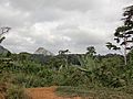
Forest
-
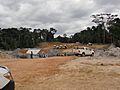
Bridge on the scheduled presidential residence (2010)
-
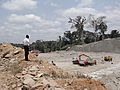
Highway under construction (2010)


Companies Helping to Build the City
Many companies are involved in building Ciudad de la Paz:
- Planning and Roads: CSCEC, Vinci SA, Egis Route
- Perimeter Highway: ARG
- Bridges: Bouygues, Besix, Vinci SA, General Works
- Buildings: CSCEC, Piccini
- Universities: Unicon
- Regional Parliament: Summa
- Presidential Palace: Seguibat
- Ministry Buildings: CSCEC
See also
 In Spanish: Oyala-Ciudad de la Paz para niños
