
Prime meridian facts for kids
A prime meridian is an imaginary line that goes around the Earth from the North Pole to the South Pole. It's super important because it's where we start measuring how far east or west a place is. Think of it as the "zero line" for longitude.

This special line, along with the 180th meridian (which is exactly opposite it on the globe), creates a giant circle around the Earth. This circle divides our planet into two halves: the Eastern Hemisphere and the Western Hemisphere. It helps us describe locations more easily.
_033.jpg)
Unlike the equator (which is set by how the Earth spins), a prime meridian can be chosen anywhere. Throughout history, different countries and mapmakers used different prime meridians. But today, almost everyone uses the Greenwich Meridian. It was chosen as the international standard in 1884. The modern IERS Reference Meridian is very close to it.
For Earth and the Moon, we measure longitude from 0° (the prime meridian) up to 180° to the east and 180° to the west. So, a place can be 50° East or 75° West. For other planets and moons in our Solar System, longitude is usually measured from 0° all the way to 360° in one direction.
Related pages
Images for kids
-
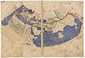
Ptolemy's map from around 1300, using a prime meridian through the Canary Islands.
-
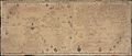
A copy of Diego Ribeiro's map from 1529.
-
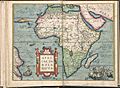
1571 Africa map by Abraham Ortelius, with Cape Verde as its prime meridian.
-
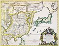
1682 map of East Asia by Giacomo Cantelli, also using Cape Verde as its prime meridian.
-
Markings of the Greenwich meridian at the Royal Observatory, Greenwich.


See also
 In Spanish: Meridiano cero para niños
