Abraham Ortelius facts for kids
Quick facts for kids
Abraham Ortelius
|
|
|---|---|
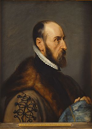
Abraham Ortelius by Peter Paul Rubens, 1633
|
|
| Born | 14 April 1527 |
| Died | 28 June 1598 (aged 71) Antwerp, Spanish Netherlands
|
| Nationality | Brabantian |
| Occupation | Geographer, cartographer |
| Known for | Creator of the first modern atlas; proposing the idea of Continental drift |
Abraham Ortelius (born April 14, 1527 – died June 28, 1598) was a famous mapmaker and geographer from the Duchy of Brabant (which is now part of Belgium). He is known for creating the very first modern atlas, called Theatrum Orbis Terrarum (which means Theatre of the World).
Ortelius is often seen as one of the key people who started the "Dutch School of Cartography." This was a golden age for mapmaking in the Netherlands, from about 1570 to 1670. His atlas, published in 1570, is often considered the start of this important period. He was also likely the first person to suggest that the continents were once joined together. He thought they later moved apart to their current places. This idea is now known as continental drift.
On May 20, 2018, Google Doodle celebrated Ortelius's work, especially his famous Theatrum Orbis Terrarum.
Contents
Life Story
Ortelius was born in Antwerp, a city that was then part of the Habsburg Netherlands (modern-day Belgium). His family originally came from Augsburg, a city in the Holy Roman Empire. In 1535, his family faced some difficulties because of their religious beliefs. After his father passed away, his uncle, Jacobus van Meteren, came back from England to help take care of Abraham. Abraham stayed close with his cousin, Emanuel van Meteren, who later moved to London.
In 1575, Ortelius became the official geographer for King Philip II of Spain. This happened because Arias Montanus spoke highly of him.
Ortelius traveled a lot across Europe. He visited many parts of the Seventeen Provinces (which are now Belgium and the Netherlands). He also traveled through Germany, France, England, Ireland, and Italy.
He started his career by engraving maps. In 1547, he joined the Antwerp Guild of Saint Luke. Here, he worked as an illuminator of maps, which means he added colors and designs to them. To earn more money, he also bought and sold books, prints, and maps. His travels included yearly visits to the Frankfurt book and print fair. It was there, in 1554, that he met another famous mapmaker, Gerardus Mercator. In 1560, Ortelius traveled with Mercator. This trip, and Mercator's influence, made Ortelius want to become a scientific geographer.
He passed away in Antwerp and was buried in the church of St. Michael's Abbey, Antwerp.
Map Publisher
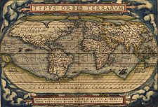
In 1564, Ortelius published his first map. It was a large wall map of the world called Typus Orbis Terrarum. This map was made of eight separate sheets. On it, he showed a land called Regio Patalis connected to Locach, stretching north from a large southern continent called Terra Australis all the way to New Guinea. A smaller version of this map later appeared in his famous atlas.
He also published other maps before his atlas came out. These included a map of Egypt in 1565, a plan of the Brittenburg castle in the Netherlands in 1568, a map of Asia in 1567, and a map of Spain.
In England, Ortelius met several important people. These included William Camden and Richard Hakluyt. Humphrey Llwyd also contributed a map of England and Wales to Ortelius's 1573 edition of the Theatrum.
In 1578, Ortelius started a project to study old maps and places. He wrote a book called Synonymia geographica. This book was later expanded and renamed Thesaurus geographicus in 1587 and again in 1596. In this last edition, Ortelius wrote about the idea of continental drift. This idea was only proven to be true many centuries later.
In 1596, the city of Antwerp honored him. His death on June 28, 1598, was a sad event for the public. His tombstone reads: Quietis cultor sine lite, uxore, prole. This means "served quietly, without accusation, wife, and offspring."
Theatrum Orbis Terrarum
On May 20, 1570, Ortelius's Theatrum Orbis Terrarum was published in Antwerp. This book, with its 53 maps, is known as the "first modern atlas." It was very popular. Three editions in Latin were published by the end of 1572. There were also editions in Dutch, French, and German. In total, twenty-five editions were released before Ortelius died in 1598. The atlas continued to be popular until about 1612.
Most of the maps in the atlas were copies of maps made by other people. Ortelius himself listed 87 authors in the first Theatrum. This list grew to 183 names in the 1601 Latin edition. Sometimes, there were small differences or errors in the maps. For example, the first maps of South America were not quite right, but they were corrected in later editions. Even with some mistakes, this atlas was a huge achievement. It showed how much Ortelius knew and how hard he worked.
In 1573, Ortelius added seventeen new maps to his atlas. These were called Additamentum Theatri Orbis Terrarum. He published four more of these additions later, with the last one appearing in 1597.
Ortelius also loved collecting old things like coins, medals, and antiques. This hobby led him to write a book in 1573 called Deorum dearumque capita... ex Museo Ortelii. This means "Heads of the gods and goddesses... from the Ortelius Museum." This book was reprinted many times.
The Theatrum Orbis Terrarum also inspired another large work called Civitates orbis terrarum. This was a six-volume book about cities around the world. Ortelius even helped with it himself.
Later Maps
In 1579, Ortelius published his Nomenclator Ptolemaicus. He also started his Parergon, which was a series of maps showing ancient history, both religious and everyday life.
In 1584, he published Itinerarium per nonnullas Galliae Belgicae partes. This was a record of a trip he took in 1575 through Belgium and the Rhineland.
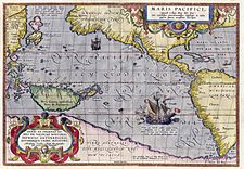
In 1589, he published Maris Pacifici. This was the first map made specifically of the Pacific Ocean. Among his last works were a book about Julius Caesar and another about the ancient Germans. He also helped with a project to publish the Peutinger Table, which is an ancient Roman road map.
Modern Use of Maps
Original maps made by Ortelius are very popular with collectors today. They can often sell for tens of thousands of dollars. You can also buy copies of his maps from many stores.
One of his maps, showing North and South America, is even part of the world's largest commercially available jigsaw puzzle. This puzzle is made by Ravensburger. It measures about 6 feet by 9 feet and has over 18,000 pieces!
Imagining Continental Drift
Ortelius was the first person to notice that the coastlines of America and Europe-Africa seemed to fit together like puzzle pieces. He suggested that the continents might have been connected long ago. He thought they were "torn away from Europe and Africa... by earthquakes and floods." He said that if you look closely at a world map, you can still see "the traces of the break."
Ortelius's idea about continents moving was later brought up again by Alfred Wegener. Wegener published his own theory of continental drift in 1912. Because Wegener's books were widely available and he also provided geological evidence, many geologists credit him with the idea.
However, in the 1960s, scientists found strong evidence for something called seafloor spreading. This showed that new ocean floor is constantly being created at mid-oceanic ridges, pushing the continents apart. This discovery finally proved that continental drift is a real, ongoing process around the world. So, more than three centuries after Ortelius first thought of it, his amazing idea was proven correct!
See also
 In Spanish: Abraham Ortelius para niños
 | Precious Adams |
 | Lauren Anderson |
 | Janet Collins |


