
New Guinea facts for kids


New Guinea is a very large island located north of Australia. It is the second biggest island in the entire world!
The eastern part of New Guinea is a country called Papua New Guinea. The western part of the island belongs to Indonesia, and it includes the provinces of Papua and West Irian Jaya.
Around 6.9 million people live on this amazing island.
New Guinea is also super important for its nature and biology. It is home to many different animals and plants found nowhere else.
Contents
New Guinea's Past: A Journey Through Time
Early Settlers and Farming

The very first people arrived in New Guinea at least 50,000 years ago. They traveled through Southeast Asia to get there. These early people are likely the ancestors of today's Papuan people.
They learned to live in different environments and even developed some of the earliest farming methods. Archaeologists are still studying old irrigation systems in the highlands of Papua New Guinea. These systems show how clever these early farmers were.
For example, sugar cane was first grown in New Guinea around 6000 BC. That's a very long time ago!
Clever Farming in the Highlands
The gardens in the New Guinea Highlands are very old and special. Farmers there learned to grow food in tough conditions. They faced lots of rain, earthquakes, and hilly land.
They used clever methods like complex mulches, rotating crops, and special ways of tilling the soil. They even used terraces with amazing irrigation systems. Some evidence suggests New Guinea gardeners invented crop rotation before people in Western Europe.
A unique tree called Casuarina oligodon was also important. This tall, strong tree helped the soil by adding nitrogen. It was used for wood and fuel, especially after a time when many trees were cut down.
Later Arrivals: Austronesian People
Many thousands of years later, another group of people arrived by sea. These were the Austronesian people. They had traveled from Taiwan and through many islands in Southeast Asia.
The Austronesian people were excellent sailors. They settled along the coastal areas and islands of New Guinea. They are believed to be the ancestors of most people living in island Southeast Asia today.
New Guinea Before European Contact
Local Kingdoms and Trade
The western part of New Guinea had contact with kingdoms in other parts of what is now Indonesia.
For example, the old text Negarakertagama mentioned a region called Wanin in eastern Nusantara. This area is thought to be the Onin Peninsula in New Guinea.
The sultans of Tidore (in the Maluku Islands) also claimed control over parts of New Guinea's coast. During their rule, New Guinea traded important goods like tree sap, spices, and the beautiful feathers of the bird-of-paradise.
Sultan Nuku, a famous Tidore sultan, even called himself "Sultan of Tidore and Papua." He led a revolt against the Dutch in the 1780s. After Tidore was defeated, much of western New Guinea came under Dutch control.
Europeans Arrive in New Guinea
First European Sightings


The first Europeans to see New Guinea were Portuguese and Spanish sailors in the 1500s. In 1526–27, the Portuguese explorer Jorge de Meneses saw the western tip and called it ilhas dos Papuas.
In 1545, the Spaniard Yñigo Ortiz de Retez sailed along the north coast. He landed on June 20 and named the island 'Nueva Guinea', which means 'New Guinea'.
The first map showing the whole island was made in 1600. In 1606, Luís Vaz de Torres explored the southern coast. He claimed some areas for Spain.
Colonial Powers Divide the Island
.png)
In 1828, the Netherlands officially claimed the western half of the island. This became Netherlands New Guinea.
Later, in 1883, the British colony of Queensland tried to claim southeastern New Guinea. However, the British government took over directly in 1884. At the same time, Germany claimed northeastern New Guinea as German New Guinea.
The Dutch, German, and British rulers tried to stop local warfare and headhunting in their areas.
In 1905, the British gave some control of southeastern New Guinea to Australia. This area was renamed "Territory of Papua" in 1906. During World War I, Australian forces took over German New Guinea. In 1920, it became the Territory of New Guinea, managed by Australia.
Discovering Hidden Valleys
Before about 1930, maps showed the highlands of New Guinea as empty forests. But when planes flew over, they saw many villages with farms!
The most amazing discovery happened on August 4, 1938. Richard Archbold found the Grand Valley of the Baliem River. About 50,000 people, known as the Dani, were living there in organized villages. They were one of the last large groups to have their first contact with the outside world.
New Guinea During and After World War II
World War II Battles

In 1942, Japanese forces invaded both Dutch New Guinea and the Australian territories. The highlands and northern and eastern parts of the island became major battlefields during World War II.
Local Papuans helped the Allies a lot. They fought alongside Australian troops and carried supplies and injured soldiers. Sadly, about 216,000 Japanese, Australian, and U.S. soldiers died during the New Guinea Campaign.
After the War
After World War II, the Australian part was called the Territory of Papua-New Guinea. The Netherlands kept control of western New Guinea.

In the 1950s, the Dutch started preparing western New Guinea for independence. They held elections in 1959. The elected New Guinea Council chose the name West Papua for the territory. They also chose a flag, the Morning Star flag, and an anthem.
However, on October 1, 1962, the Dutch handed the territory to the United Nations Temporary Executive Authority. Then, on May 1, 1963, Indonesia took control. The territory was renamed West Irian, and later Irian Jaya. In 1969, Indonesia held a vote called the Act of Free Choice. In this vote, chosen Papuan elders agreed to stay with Indonesia.
Some people have resisted Indonesian rule. Groups like the Organisasi Papua Merdeka (OPM, or Free Papua Movement) formed in 1965.

The Australian territory was renamed Papua New Guinea in 1971. On September 16, 1975, Australia gave full independence to Papua New Guinea.
In 2000, Irian Jaya was officially renamed "The Province of Papua." A special law for self-rule was passed in 2001.
People of New Guinea

Today, about eleven million people live on the island of New Guinea. Many experts believe people have lived here for at least 50,000 years. Some even suggest it could be as long as 60,000 years!
The island is home to nearly a thousand different tribal groups. They speak almost as many different languages. This makes New Guinea the place with the most language diversity in the world!

These languages fall into two main groups: the Papuan languages and the Austronesian languages.
Most of the island's people, the Papuans, are thought to be descendants of the very first humans who came to New Guinea. These early people arrived when New Guinea was connected to Australia by a land bridge. This large landmass was called Sahul.
The ancestral Austronesian people arrived much later, about 3,500 years ago. They came by sea from Southeast Asia. They settled on many islands around New Guinea and along its coasts.

Over thousands of years, many different groups of people have come to New Guinea. This has created a huge amount of cultural diversity. About half of the 2.4 million people in Indonesian Papua are migrants from Java.
Large parts of New Guinea are still unexplored by scientists. The Indonesian province of West Papua is believed to have about 44 uncontacted tribal groups.
Amazing Nature and Wildlife
New Guinea is a tropical land covering about 786,000 square kilometers. Even though it's less than half a percent of Earth's surface, it has incredible biodiversity. It holds between 5% and 10% of all the species on the planet! This is similar to the number of species found in the United States or Australia.
Many of New Guinea's species are endemic, meaning they are found nowhere else. Thousands of species are still unknown to science. There could be over 200,000 insect species, 11,000 to 20,000 plant species, and over 650 types of birds.
Most of these species are related to those in Australia. This is because New Guinea and Australia were once part of the same landmass. The island is so big and unique that it's almost like its own continent for its wildlife.


New Guinea is part of Australasia in terms of its animals. However, its plants have more in common with Asia.
Botanically, New Guinea is part of Malesia, a plant region stretching from the Malay Peninsula to New Guinea. New Guinea's plants are a mix of Asian tropical rainforest species and typical Australasian plants. You can find conifers like Podocarpus, tall Araucaria and Agathis trees, tree ferns, and several types of Eucalyptus.
New Guinea has 284 species of mammals. These include monotremes (like echidnas), three types of marsupials (like kangaroos), rodents, and bats. A huge 69% of these mammal species are endemic!
The island also has 578 species of breeding birds, with 324 of them being endemic. New Guinea's frogs are not fully known, but there are at least 282 species. This number is expected to grow a lot as more are discovered.
New Guinea has a rich variety of coral life. About 1,200 species of fish have been found there. Also, there are about 600 species of reef-building coral, which is 75% of the world's known total! This amazing coral area covers 18 million hectares off a peninsula in northwest New Guinea.

Different Natural Areas
Land Ecoregions

The WWF divides New Guinea into twelve different land ecoregions, each with its own unique plants and animals:
- Central Range montane rain forests
- Central Range sub-alpine grasslands
- Huon Peninsula montane rain forests
- New Guinea mangroves
- Northern New Guinea lowland rain and freshwater swamp forests
- Northern New Guinea montane rain forests
- Southeastern Papuan rain forests
- Southern New Guinea freshwater swamp forests
- Southern New Guinea lowland rain forests
- Trans Fly savanna and grasslands
- Vogelkop montane rain forests
- Vogelkop-Aru lowland rain forests
Freshwater Ecoregions
The WWF and Nature Conservancy also divide New Guinea into five freshwater ecoregions:
- Vogelkop–Bomberai
- New Guinea North Coast
- New Guinea Central Mountains
- Southwest New Guinea–Trans-Fly Lowland
- Papuan Peninsula
Ocean Ecoregions
The seas around New Guinea also have several marine ecoregions:
- Papua
- Bismarck Sea
- Solomon Sea
- Southeast Papua New Guinea
- Gulf of Papua
- Arafura Sea
Images for kids
-
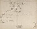
A 1644 map of New Guinea and the surrounding area.
-
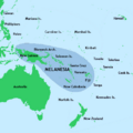
New Guinea is part of the Melanesian cultural area.
-
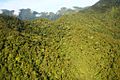
Mount Bosavi, a large volcano.
-
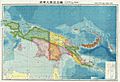
A Japanese military map of New Guinea from 1943.


See also
 In Spanish: Nueva Guinea para niños
