Arafura Sea facts for kids
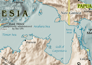
The Arafura Sea is a large body of water located west of the Pacific Ocean. It sits on top of the continental shelf between the countries of Australia and New Guinea.
Contents
About the Arafura Sea
The Arafura Sea is surrounded by several other important bodies of water. To its east, you'll find the Torres Strait and the Coral Sea. The Gulf of Carpentaria is to its south. To the west, it meets the Timor Sea. Finally, to the northwest, it connects with the Banda and Ceram seas.
Size and Depth
This sea is quite large, stretching about 1,290 kilometres (800 mi) long. It is also around 560 kilometres (350 mi) wide. The Arafura Sea is mostly shallow. Its depth is usually between 50 and 80 metres (165–265 feet). The water gets a bit deeper as you move towards the west.
Tropical Cyclones
Because the Arafura Sea is shallow and located in a warm, tropical area, its waters are often where tropical cyclones begin. These are powerful storms that can cause a lot of wind and rain.
Arafura Shelf and Ancient Land Bridge
The Arafura Sea lies over something called the Arafura Shelf. This shelf is part of a bigger area known as the Sahul Shelf.
Connecting Continents
Many thousands of years ago, during the last Ice Age, the sea levels were much lower than they are today. At that time, the Arafura Shelf, the Gulf of Carpentaria, and the Torres Strait were not covered by water. Instead, they formed a huge, flat land bridge. This land bridge connected Australia and New Guinea.
Human Migration
This ancient land bridge was very important. It allowed early humans to travel from Asia into Australia. The combined landmass of Australia and New Guinea, connected by this bridge, is known as the continent of Sahul.
See also
 In Spanish: Mar de Arafura para niños
 | Ernest Everett Just |
 | Mary Jackson |
 | Emmett Chappelle |
 | Marie Maynard Daly |


