
Gulf of Carpentaria facts for kids


The Gulf of Carpentaria (14°00′S 139°00′E / 14.000°S 139.000°E) is a big, shallow sea in northern Australia. It is surrounded by land on three sides. To its north is the Arafura Sea, which lies between Australia and New Guinea.
The Gulf is very wide. At its opening, it is about 590 kilometers (366 miles) across. Further south, it stretches to 675 kilometers (419 miles) wide. From north to south, it is more than 700 kilometers (435 miles) long. The total water area is about 300,000 square kilometers (115,831 square miles).
The Gulf is mostly shallow, usually between 55 and 66 meters (180 to 216 feet) deep. However, some spots can be as deep as 82 meters (269 feet). During the last ice age, this area was dry land.
Contents
Geography of the Gulf
The land around the Gulf of Carpentaria is mostly flat and low.
Surrounding Lands
- To the west, you'll find Arnhem Land and the Top End of the Northern Territory. Groote Eylandt, the largest island in the Gulf, is also here.
- To the east is the Cape York Peninsula.
- The area to the south is part of Queensland. It is known as the Gulf Country or simply "the Gulf."
Climate and Weather
The climate in the Gulf region is hot and humid. It has two main seasons each year.
Dry Season
The dry season lasts from about April to November. During this time, dry winds blow from the southeast to the east. These winds are caused by high-pressure systems in the south during winter.
Wet Season
The wet season runs from December to March. Most of the year's rain falls during these months. Many low-lying areas often become flooded. The Gulf is also a place where tropical cyclones form between November and April.
Morning Glory Cloud
In September and October, a special cloud formation called the Morning Glory cloud appears in the Southern Gulf. The best place to see this amazing cloud is near Burketown shortly after dawn.
European Exploration of the Gulf
Many European explorers visited the Gulf of Carpentaria over the centuries.
Early Visits
The first known European to visit this area was the Dutch explorer Willem Janszoon in 1606. Later, in 1623, Jan Carstenszoon explored the Gulf. He named it after Pieter de Carpentier, who was the Governor-General of the Dutch East Indies at that time. Abel Tasman also explored the coast in 1644.
Mapping the Gulf
Much later, in 1802 and 1803, Matthew Flinders explored and mapped the area in more detail.
Overland Expedition
The first overland journey to reach the Gulf was the Burke and Wills expedition. This expedition was led by Robert O'Hara Burke and William John Wills. They left Melbourne in August 1860 and arrived at the Bynoe River in February 1861.
Rivers Flowing into the Gulf
Many rivers flow into the Gulf of Carpentaria. These include:
- Archer River
- Calvert River
- Cox River
- Flinders River
- Gilbert River
- Leichhardt River
- McArthur River
- Mission River
- Mitchell River
- Alice River
- Norman River
- Roper River
- Wilton River
- Smithburne River
- Staaten River
- Wenlock River
Images for kids
-
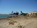
Loading ore from McArthur River zinc mine at Bing Bong Loading Facility, 2011
-
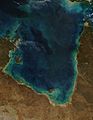
Gulf of Carpentaria from MODIS
-
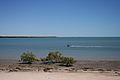
Karumba Beach, Karumba, Queensland
-
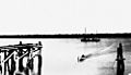
Melbidir II anchored off Karumba near the mouth of the Norman River


See also
 In Spanish: Golfo de Carpentaria para niños
