
Northern Territory facts for kids
Quick facts for kids
Northern Territory
|
|||
|---|---|---|---|
|
|||
Nickname(s):
|
|||
|
Location of Northern Territory in Australia
Coordinates: 20°S 133°E / 20°S 133°E |
|||
| Country | Australia | ||
| Established by New South Wales | 1825 | ||
| Transferred to South Australia | 1863 | ||
| Transferred to Commonwealth | 1911 | ||
| Responsible government | 1 July 1978 | ||
| Capital
and largest city
|
Darwin 12°26′17″S 130°50′28″E / 12.43806°S 130.84111°E |
||
| Administration | 17 local government areas | ||
| Common languages |
|
||
| Demonym(s) |
|
||
| Government | |||
|
• Monarch
|
Charles III | ||
| Hugh Heggie | |||
| Lia Finocchiaro (CLP) | |||
| Legislature | Northern Territory Legislative Assembly | ||
| Parliament of Australia | |||
|
• Senate
|
2 senators (of 76) | ||
| 2 seats (of 150) | |||
| Area | |||
|
• Land
|
1,347,791 km2 (520,385 sq mi) | ||
| Highest elevation
(Mount Zeil)
|
1,531 m (5,023 ft) | ||
| Population | |||
|
• December 2021 estimate
|
260,400 (8th) | ||
|
• Density
|
0.19/km2 (0.5/sq mi) (8th) | ||
| GDP (nominal) | 2020 estimate | ||
|
• Total
|
AU$26.153 billion (8th) | ||
|
• Per capita
|
AU$106,851 (2nd) | ||
| HDI (2021) | very high · 6th |
||
| Time zone | UTC+09:30 (ACST) | ||
| Postal abbreviation |
NT
|
||
| ISO 3166 code | AU-NT | ||
| Symbols | |||
| Mammal | Red kangaroo (Macropus rufus) |
||
| Bird | Wedge-tailed eagle (Aquila audax) |
||
| Flower | Sturt's desert rose (Gossypium sturtianum) |
||
| Colour | Black, white, and ochre | ||


The Northern Territory (often called the NT or just the Territory) is a large part of Australia. It's located in the central and northern areas of the country. To its west is Western Australia, to the south is South Australia, and to the east is Queensland. Looking north, the Territory meets the Timor Sea, the Arafura Sea, and the Gulf of Carpentaria.
The Northern Territory is huge, covering about 1,347,791 square kilometers. This makes it the third-largest area in Australia. Even though it's so big, not many people live there. As of March 2025, only about 260,400 people call it home. This is less than half the population of Tasmania.
Most people live in the capital city, Darwin, which has about half of the Territory's population. The biggest town away from the coast is Alice Springs, with around 25,000 residents. Other important towns include Palmerston, Katherine, Nhulunbuy, and Tennant Creek. People who live in the Northern Territory are often called "Territorians."
People have lived in this region for over 60,000 years. Long ago, traders from Sulawesi (an island in Indonesia) visited the coast. Europeans first saw the coast in the 1600s. The British tried to settle here several times, finally succeeding in 1869 when they started a settlement at Port Darwin. Today, the Territory's economy mainly relies on mining and oil.
Contents
- The Northern Territory: Australia's Unique Top End
- Images for kids
The Northern Territory: Australia's Unique Top End
A Look Back: History of the Territory
Early Days: Ancient People and Traders
Humans have lived in the area now known as the Northern Territory for tens of thousands of years. These were the Indigenous peoples who developed rich cultures. From the 17th or 18th century, traders from Sulawesi (an island in Indonesia) visited the northern coast.
They traded with Indigenous people for trepang (sea cucumbers), which were sold in Chinese markets. These traders also brought new goods and technologies. We can still see signs of their visits in ancient Indigenous Australian rock art and bark painting.
European Settlement and Growth
Europeans first saw the Territory's coast in the 1600s. The British made several attempts to settle the northern coast. Many of these early attempts failed because of the harsh environment. Finally, in 1869, a successful settlement was established at Port Darwin.
The land was part of New South Wales from 1825 to 1863. Then, it became part of South Australia until 1911. During this time, the important Australian Overland Telegraph Line was built. This line connected Australia to the rest of the world.
The Port of Darwin became a key supply point for the Territory. A railway was built between Palmerston and Pine Creek in the late 1800s. Cattle farming and mining for gold and copper also became important industries.

Becoming Part of Australia
On January 1, 1911, the Northern Territory officially separated from South Australia. It then came under the control of the Australian federal government. At this time, there was a strong belief that the Territory needed more people.
For a short period between 1927 and 1931, the Northern Territory was even divided into two parts: North Australia and Central Australia. There were also discussions about changing its name, with "Kingsland" being a popular idea, but the name stayed the same.

Modern Times and Self-Government
During World War II, the northern part of the Territory was under military control. This was the only time an Australian state or territory was governed by the military since Australia became a federation. Darwin experienced a major attack during the war, known as the Bombing of Darwin in 1942.
After the war, Indigenous Australians began a long struggle for fair wages and land rights. A significant event was the Gurindji strike in 1966. This led to the Aboriginal Land Rights (Northern Territory) Act 1976. This law helped Indigenous people gain legal rights to their traditional lands.
In 1974, Cyclone Tracy hit Darwin, causing huge damage and leaving many people homeless. The city was rebuilt with stronger building rules. In 1978, the Northern Territory gained Self-Government. This meant it could make many of its own laws through its own parliament.
In the 1980s, famous places like Kakadu National Park and Uluru-Kata Tjuta National Park became World Heritage Sites. They are recognized for their amazing nature and important Aboriginal culture.
Exploring the Land: Geography and Nature

Amazing Landscapes and Rivers
The Northern Territory has many small towns, but most people live along the Stuart Highway. This is the main paved road connecting Darwin to southern Australia. The Territory is famous for its incredible natural rock formations. These include Uluru / Ayers Rock and Kata Tjuta / The Olgas in Central Australia.
These sites are very important to the local Aboriginal people. They are also major tourist attractions and UNESCO World Heritage sites. The northern part of the Territory has tropical savannas with tall grasses and scattered trees. The southern part is mostly desert, including parts of the Simpson Desert.
Many rivers flow through the Territory, such as the Daly River, Finke River, and Victoria River. These rivers are vital for the wildlife and people living there.

Protecting Nature: National Parks
The Northern Territory is home to many beautiful national parks and protected areas. These parks help protect the unique plants, animals, and cultural sites. Some of the well-known parks include:
- Kakadu National Park
- Uluṟu-Kata Tjuṯa National Park
- Litchfield National Park
- Nitmiluk National Park
- Watarrka National Park
Weather Wonders: Climate Zones

The Northern Territory has two main climate zones. The northern part, where Darwin is, has a tropical climate. It has a wet season (October to April) and a dry season (May to September). The dry season is usually sunny and warm with little rain.
The wet season brings high humidity, thunderstorms, and tropical cyclones. Most rain falls between December and March. The central part of the Territory, around Alice Springs and Uluru, has a semi-arid desert climate. It has very hot summers and cool winters. Frost can occur a few times a year. This region receives much less rain than the north.
The highest temperature ever recorded was 48.3°C in Finke in January 1960. The lowest was -7.5°C in Alice Springs in July 1976.

How the Territory is Governed
,_Parliament_House_--_2019_--_4336-8.jpg)
Making Laws: The Parliament
The Northern Territory has its own parliament called the Northern Territory Legislative Assembly. It was created in 1974. This parliament makes laws for the Territory, similar to how state parliaments work. However, the Australian federal government can still make laws for the Territory if needed.
The King of Australia is represented by the Administrator of the Northern Territory. This person has a role similar to a state governor. Twenty-five members are elected to the Legislative Assembly for four-year terms.
Leaders and Representatives
The head of the Territory's government is the Chief Minister of the Northern Territory. The Administrator appoints the Chief Minister, usually the leader of the party with the most seats. As of August 2024, Lia Finocchiaro of the Country Liberal Party is the Chief Minister.
The current Administrator is Hugh Heggie, who started his term in January 2023. The Northern Territory also sends two members to the Australian House of Representatives and two members to the Australian Senate in the federal parliament.

Local Councils and Indigenous Land
The Northern Territory is divided into 17 local government areas. These include cities, municipalities, regions, and shires. These local councils manage things like roads and waste collection. They get money from property taxes and government grants.
Aboriginal land councils are important groups of Aboriginal landowners. They were set up under the Aboriginal Land Rights Act 1976. These councils help manage and protect Aboriginal lands. Indigenous Australians own about 49% of the Northern Territory's land.

The main political parties in the Territory are the Country Liberal Party (CLP) and the Australian Labor Party. Sometimes, independent politicians also win elections. In 2024, the NT Greens won their first seat in the Legislative Assembly.
Who Lives Here: People and Culture

Population and Major Towns
The Northern Territory's population is the youngest in Australia. It has the highest percentage of people under 15 years old. The average age of residents is 31 years, which is younger than the national average.
Indigenous Australians make up about 30.3% of the population. They live in communities across the Territory. Some of the largest Indigenous groups include the Pitjantjatjara near Uluru and the Arrernte near Alice Springs.

Most of the Territory's population lives in Darwin. Despite this, the Northern Territory is the least urbanized part of Australia.
.jpg)
Here are the largest urban centers by population (2021 Census):
- Darwin: 122,207
- Alice Springs: 24,855
- Katherine: 5,980
- Nhulunbuy: 3,267
- Tennant Creek: 2,949
Diverse Backgrounds and Languages
Many people in the Northern Territory were born overseas, making it a diverse place. The most common ancestries include Indigenous, Australian, English, Irish, and Scottish.
While most people speak English at home, many other languages are also spoken. There are over 100 Aboriginal languages and dialects. Some major Indigenous languages include Murrinh-patha, Warlpiri, Arrernte, and Yolngu Matha.

Beliefs and Traditions
Christianity is the largest religion in the Northern Territory, followed by about 40.5% of the population in 2021. However, the number of people who say they have no religious affiliation has grown. In 2021, 38.5% of people reported having no religion.
Other religions like Hinduism, Buddhism, and Islam are also practiced in the Territory.
Learning and Growing: Education

Schools for All Ages
Children in the Northern Territory start school around age five. Their education includes six years of primary school, three years of middle school (Years 7-9), and three years of secondary school (Years 10-12). When students finish secondary school, they receive the Northern Territory Certificate of Education and Training (NTCET). This certificate helps them get into university.
Schools in the Territory can be public (government-funded) or private (fee-paying). Private schools include those run by the Catholic Church and other independent schools. Many independent schools are linked to different Christian churches.
Higher Learning and Libraries
The main university in the Northern Territory is Charles Darwin University. It opened in 1989 and offers both university degrees and vocational training courses. The first higher education institution for Indigenous people, the Batchelor Institute of Indigenous Tertiary Education, was established in the 1960s.
Library & Archives NT is the Territory's public research library and archive. It helps support library services across the region. The National Archives of Australia also has a branch in Darwin.
What Drives the Economy

Mining and Resources
The Northern Territory's economy relies heavily on mining. This industry focuses on minerals, oil, and gas. It contributes billions of dollars to the economy and employs thousands of people. Mining makes up a much larger part of the Territory's economy compared to the rest of Australia.
In recent years, construction has also become a very important industry. This is due to large building projects and mine expansions. The Territory's economy has grown significantly over the last decade.
The main mining activities include bauxite (used to make aluminum), manganese, gold, and uranium. The Territory exports many of these resources to countries like Japan, China, and Indonesia.
Welcoming Visitors: Tourism
Tourism is a very important part of the Territory's economy. It brings many visitors to famous places like Uluru / Ayers Rock and Kakadu National Park. People come to see the diverse landscapes, waterfalls, and unique wildlife. They also come to experience Aboriginal culture.
In 2015, about 1.6 million visitors came to the Territory. They contributed an estimated $2.0 billion to the local economy. Tourism supports many other businesses, such as hotels, restaurants, shops, and transport services. The Wide Open Space festival is an annual event celebrating music, arts, and culture near Alice Springs.
Getting Around: Transport

The Northern Territory is very spread out, so transport is crucial. It has a network of sealed roads, including two national highways. These roads connect major towns and link the Territory to other Australian states. The Stuart Highway runs from north to south, connecting Darwin and Alice Springs to Adelaide.
Many remote settlements are connected by unsealed (dirt) roads. Driving long distances can be tiring, and conditions can be challenging. The Territory government runs road safety campaigns to help people drive safely. Speed limits in towns are usually 50 or 60 kilometers per hour. Outside built-up areas, the limit is often 110 km/h, with some sections allowing 130 km/h.
In 2004, a railway line was completed between Alice Springs and Darwin. This finished a long-held dream of a transcontinental railway. The line carries freight and a special passenger train called The Ghan. This train offers a unique travel experience between Darwin and Adelaide.
.JPG)
Darwin International Airport is the main airport for the Territory. There are also smaller airports throughout the region, like Alice Springs Airport and Katherine Airport.
News and Entertainment: Media
Newspapers, TV, and Radio
The Northern Territory has one daily newspaper, the Northern Territory News (or NT News). Its Sunday version is The Sunday Territorian. The Centralian Advocate is published twice a week in the Alice Springs area.
There are five main television stations in Darwin: ABC, SBS, Southern Cross Seven, Nine Network Darwin, and Ten Darwin. Regional areas have similar channels. Remote areas often receive TV through satellite services.
Radio stations are available on both AM and FM frequencies. In Darwin, you can listen to ABC stations like ABC Radio Darwin and Triple J, as well as commercial stations like Hot 100 FM. Alice Springs also has a variety of ABC, commercial, and community radio stations.
Fun and Games: Sport and Culture
Australian rules football in the Northern Territory is very popular, especially in Indigenous communities. The main organization for football in the Territory is the AFL Northern Territory.
The Northern Territory is also home to important cultural places. These include the Araluen Art Centre and the Museum of Central Australia in Alice Springs. The Darwin Symphony Orchestra and the Museum and Art Gallery of the Northern Territory are also key cultural institutions.
Images for kids
-
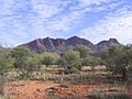
Mount Sonder, a beautiful peak in West MacDonnell National Park.
-
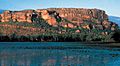
Nourlangie Rock in Kakadu National Park, known for its ancient rock art.
-
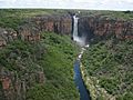
Jim Jim Falls, a stunning waterfall in Kakadu National Park.
-
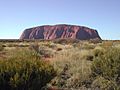
Uluru / Ayers Rock, an iconic natural landmark in the Northern Territory.
-
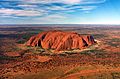
An aerial view of Uluru / Ayers Rock.
-

A panoramic view of Kata Tjuta / The Olgas in Uluṟu-Kata Tjuṯa National Park.


