
Stuart Highway facts for kids
Quick facts for kids Stuart HighwayNorthern Territory–South Australia |
|
|---|---|
.jpg) |
|
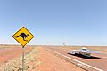
| The highway in the far north of South Australia | |
 |
|
| Map of Australia (except Tasmania), with Stuart Highway highlighted in red | |
| General information | |
| Type | Highway |
| Length | 2,834 km (1,761 mi) |
| Route number(s) |
|
| Former route number |
National Route 87 (NT/SA border – Port Augusta) |
| Major junctions | |
| North end | Daly Street, Darwin, Northern Territory |
|
|
| South end | Princes Highway / Eyre Highway (National Highway A1), Port Augusta, South Australia |
| Location(s) | |
| Major settlements | Katherine, Daly Waters, Tennant Creek, Alice Springs, Coober Pedy |
| Highway system | |
| Highways in Australia National Highway • Freeways in Australia Highways in the Northern Territory Highways in South Australia |
|
The Stuart Highway is one of Australia's most important roads. It connects Port Augusta in South Australia with Darwin in the Northern Territory. This long road stretches for 2,834 kilometres.
The highway is named after a famous explorer, John McDouall Stuart. Much of the road follows the path he took on his amazing journey in 1862. Today, the Stuart Highway is a popular place for tourists. It is often called the "Explorer's Way." For many years, people in Australia simply called it "The Track."
Contents
Towns Along the Highway
Many towns are located along the Stuart Highway. These towns are important stops for travellers. Some of the main towns include:
What is the Stuart Highway Used For?
The Stuart Highway is a vital link for Australia. It helps people and goods travel between the north and south of the country. It is also a key route for tourists wanting to explore Australia's outback. The highway is part of the National Highway system. This system helps connect major cities across Australia.
History of the Highway
The idea for the Stuart Highway came from John McDouall Stuart's explorations. He was the first European to cross Australia from south to north. Building a road along his route helped open up the centre of Australia. Over time, the road was improved and became the highway we know today.
Images for kids
-
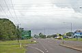
Stuart Highway intersection in Berrimah, Northern Territory
-
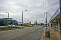
Stuart Highway at Stuart Park, Northern Territory
-
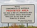
The highway passes through the Woomera Prohibited Area
-
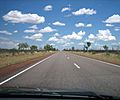
Stuart Highway in the Northern Territory
-
Solar Car "Tokai Challenger" during the 2009 World Solar Challenge


See also
 In Spanish: Carretera Stuart para niños
