
South Australia facts for kids
Quick facts for kids
South Australia
|
|||
|---|---|---|---|
|
|||
Nickname(s):
|
|||
| Country | Australia | ||
| Before federation | Province of South Australia | ||
| Settlement | 15 August 1834 | ||
| Declared as Province | 19 February 1836 | ||
| Responsible government | 22 April 1857 | ||
| Federation | 1 January 1901 | ||
| Capital
and largest city
|
Adelaide | ||
| Administration | 74 local government areas | ||
| Demonym(s) |
|
||
| Government | |||
|
• Monarch
|
Charles III | ||
|
• Governor
|
Frances Adamson | ||
|
• Premier
|
Peter Malinauskas (Labor) | ||
| Legislature | Parliament of South Australia | ||
| Legislative Council | |||
| House of Assembly | |||
| Parliament of Australia | |||
|
• Senate
|
12 senators (of 76) | ||
| 10 seats (of 151) | |||
| Area | |||
|
• Land
|
984,321 km2 (380,048 sq mi) | ||
| Highest elevation | 1,435 m (4,708 ft) | ||
| Lowest elevation | -16 m (−52.5 ft) | ||
| Population | |||
|
• March 2022 estimate
|
1,815,485 (5th) | ||
|
• Density
|
1.84/km2 (4.8/sq mi) (6th) | ||
| GDP (nominal) | 2020 estimate | ||
|
• Total
|
AU$108.334 billion (5th) | ||
|
• Per capita
|
AU$61,582 (7th) | ||
| HDI (2021) | very high · 7th |
||
| Time zone |
|
||
|
• Summer (DST)
|
UTC+10:30 (ACDT) | ||
| Postal abbreviation |
SA
|
||
| ISO 3166 code | AU–SA | ||
| Symbols | |||
| Mammal | Southern hairy-nosed wombat (Lasiorhinus latifrons) |
||
| Bird | Piping shrike (Australian magpie) | ||
| Fish | Leafy seadragon< | ||
| Flower | Sturt's Desert Pea (Swainsona formosa) |
||
| Fossil | Spriggina floundersi | ||
| Mineral | Bornite, Opal as Gem | ||
| Colour | Red, blue, and gold | ||


South Australia (often called SA) is a state in the southern middle part of Australia. It includes some of the driest areas of the country. With a total land area of 984,321 square kilometers, it is the fourth-largest state or territory in Australia by size. However, it has the second smallest population among the states. About 1.8 million people live there.
Most of South Australia's people, over 77 percent, live in the capital city, Adelaide, or nearby. Other towns are much smaller. Mount Gambier, the second-largest town, has about 26,878 people. South Australia shares borders with all other mainland states. It borders Western Australia to the west and the Northern Territory to the north. To the northeast is Queensland, to the east is New South Wales, and to the southeast is Victoria. The Great Australian Bight is to the south.
South Australia has less than 8 percent of Australia's total population. Most people live in or around Adelaide. Others live in fertile areas along the southeastern coast and the River Murray. South Australia was settled differently from other parts of Australia. It was a planned British province for free settlers, not a convict settlement. Its government started on December 28, 1836.
Like the rest of Australia, this area has a long history of human life. Many different Aboriginal tribes and languages existed here. The South Australian Company set up a temporary camp at Kingscote, Kangaroo Island, on July 26, 1836. This was five months before Adelaide was founded. The idea behind the settlement was "systematic colonisation." This theory was promoted by Edward Gibbon Wakefield. The goal was to create a place for free immigrants. It promised civil liberties and religious freedom.
South Australia has faced tough economic times. But it has always been creative in politics and culture. Today, it is famous for its great wine and many cultural festivals. The state's economy mainly depends on farming, making things, and mining.
Contents
Exploring South Australia's Past

Ancient History and First Peoples
People have lived in South Australia for at least 20,000 years. There is proof of flint mining and rock art in the Koonalda Cave. This cave is on the Nullarbor Plain. Wooden spears and tools were also found in the South East. Kangaroo Island was home to people long before rising sea levels cut it off. Research suggests Aboriginal people reached Eyre Peninsula about 49,000 to 45,000 years ago. They came from both the east and the west.
European Discoveries
The first time Europeans saw the South Australian coast was in 1627. A Dutch ship, the Gulden Zeepaert, explored and mapped part of the coastline. This was as far east as the Nuyts Archipelago. The captain, François Thijssen, named the land "Nuyts Land." This was after a passenger, Pieter Nuyts.
The coast of South Australia was first fully mapped in 1802. This was done by Matthew Flinders and Nicolas Baudin. The Port Adelaide River was found later in 1831 by Captain Collet Barker. It was then mapped well in 1836–37 by Colonel William Light. He was the first Surveyor-General of South Australia.

British Settlement and Unique Beginnings
In 1788, Britain claimed the land that is now South Australia. It became part of the colony of New South Wales. Early British settlements were all on the eastern coast. Few explorers went as far west as South Australia. It took over 40 years before anyone seriously suggested settling this area.
On August 15, 1834, the British Parliament passed the South Australia Act 1834. This law allowed the King to create new provinces in southern Australia. The act said the land between 132° and 141° east longitude would be for the new colony. It would also be a place where no convicts were sent.

Unlike the rest of Australia, the idea of terra nullius (empty land) did not apply here. The official document creating the Province of South Australia said that the rights of Aboriginal people to their land would not be affected. However, the South Australian Company and settlers often ignored these rights. Despite early promises, there were many conflicts and deaths during the Australian frontier wars in South Australia.
Before settlement, the land needed to be surveyed. William Light was chosen to lead the "First Expedition." His job was to explore 1500 miles of coastline. He had to pick the best spot for the capital city. Then he had to plan and survey the city itself.
The South Australian Company wanted to start their whale and seal fishing. So, they got permission to send ships to South Australia early. These ships arrived before the surveys were finished.
The company's first settlement was at Kingscote on Kangaroo Island. This was a temporary spot. William Light later chose the current location of Adelaide for the capital. The first immigrants arrived at Holdfast Bay in November 1836. This is near today's Glenelg.
Colonial government officially began on December 28, 1836. This day is now called Proclamation Day. South Australia is the only Australian state that never received British convicts. Some former convicts or escapees did make their way there. But they were a very small part of the early population.
The plan for the province was to be a new kind of experiment. It aimed to fix problems seen in British society. There would be religious freedom, with no official state religion. Selling land to settlers created a fund to help poor young workers move to South Australia. In 1838, people worried that escaped convicts from other states might come to South Australia. The South Australia Police was formed in April 1838 to keep the peace.
The current flag of South Australia was adopted on January 13, 1904. It shows a piping shrike with its wings spread out on a yellow circle. This bird is a type of Australian magpie.
Amazing Geography and Climate

Landforms and Features
South Australia's land is mostly dry and semi-dry rangelands. It has several low mountain ranges. The most important range is the Mount Lofty-Flinders Ranges system. It stretches about 800 kilometers north from Cape Jervis. The highest point in the state is Mount Woodroffe. It is 1,435 meters high and is in the Musgrave Ranges in the far northwest.
The southwestern part of the state is the Nullarbor Plain. This is a vast, flat, treeless area. It faces the cliffs of the Great Australian Bight. Along the coast, you'll find Spencer Gulf and the Eyre and Yorke Peninsulas. The Temperate Grassland of South Australia is east of Gulf St Vincent.


Climate and Weather
The southern part of South Australia has a Mediterranean climate. This means it has warm, dry summers and mild, wet winters. The rest of the state has a desert or semi-arid climate, which is very dry.
South Australia's average temperature is about 29°C in January and 15°C in July. The hottest temperature ever recorded in Australia was 50.7°C. This happened in Oodnadatta, South Australia, on January 2, 1960. The coldest temperature was -8.2°C in Yongala on July 20, 1976. The state's generally dry weather is due to the Australian High weather system.
| Climate data for South Australia | |||||||||||||
|---|---|---|---|---|---|---|---|---|---|---|---|---|---|
| Month | Jan | Feb | Mar | Apr | May | Jun | Jul | Aug | Sep | Oct | Nov | Dec | Year |
| Record high °C (°F) | 50.7 (123.3) |
48.2 (118.8) |
46.5 (115.7) |
42.1 (107.8) |
36.5 (97.7) |
34.0 (93.2) |
34.2 (93.6) |
36.5 (97.7) |
41.5 (106.7) |
45.4 (113.7) |
47.9 (118.2) |
49.9 (121.8) |
50.7 (123.3) |
| Record low °C (°F) | 0.2 (32.4) |
0.8 (33.4) |
−2.2 (28.0) |
−3.5 (25.7) |
−6.6 (20.1) |
−8.1 (17.4) |
−8.2 (17.2) |
−6.6 (20.1) |
−4.5 (23.9) |
−4.4 (24.1) |
−2.4 (27.7) |
−0.5 (31.1) |
−8.2 (17.2) |
| Source: Bureau of Meteorology | |||||||||||||
State Borders
South Australia shares borders with almost every other Australian mainland state and territory. It does not border the Australian Capital Territory or the Jervis Bay Territory. The border with Western Australia was marked on the ground in the 1920s.
In 1863, the part of New South Wales north of South Australia was added to it. This area became the "Northern Territory of South Australia." It was later just called the Northern Territory. In 1911, the Northern Territory became a separate territory.
Australian maps show South Australia's south coast next to the Southern Ocean. However, official international rules define the Southern Ocean as further south. So, the south coast is officially next to the southern part of the Indian Ocean.
What South Australia Makes

South Australia's economy relies heavily on exports. This means it sells more goods to other countries than any other Australian state. The biggest job sectors are healthcare, retail, education, manufacturing, and construction.
In 2020–21, South Australia's economy grew by 3.9%. This was better than other Australian states after the COVID-19 recession. This growth was partly due to a strong farming sector. Farming production increased by almost 24% because a drought ended.
Farming and Food
Agriculture is a huge industry for South Australia. The main things grown and exported are wheat, wine, and wool.
.jpeg)

- Grains and Legumes: Farmers grow wheat, barley, oats, rye, peas, beans, chickpeas, lentils, and canola.
- Fruits and Vegetables: Apples, pears, cherries, and strawberries are grown in the Adelaide Hills. Tomatoes, capsicums, cucumbers, and lettuce are grown on the Northern Adelaide Plains. Almonds, citrus, and stone fruit come from the Riverland. Potatoes, onions, and carrots are grown in the Murray Mallee region and on Kangaroo Island.
- Wine Production: South Australia makes more than half of all Australian wine. It produces almost 80% of Australia's best wines. Key wine regions include Barossa Valley, Clare Valley, McLaren Vale, Coonawarra, the Riverland, and the Adelaide Hills.
Powering the State
South Australia is a leader in renewable energy in Australia. It produces the most wind power in the country. Renewable energy is a growing source of electricity here. The Hornsdale Power Reserve is a huge battery system. When it was built in 2017, it was the largest lithium-ion battery in the world.
Mining for Riches
The Olympic Dam mine is near Roxby Downs. It has the world's largest deposit of uranium. It also has the world's fourth-largest copper deposit and fifth-largest gold deposit. This mine is a big part of global uranium production.
The remote town of Coober Pedy produces more opal than anywhere else. Opal was first found there in 1915. Many immigrants came to the town after World War II to search for opal.
Learning and Research
Schools and Learning
In South Australia, education is required for all children until age 17. Most students complete their South Australian Certificate of Education (SACE). The state government is in charge of school education. Both the state and federal governments help fund public and private schools.
Since 2013, South Australia has been part of the Gonski Reform Program. This program has increased funding for primary and secondary education. The school year usually runs from late January to mid-December. Schools have four terms and close for public holidays.
Universities and Research
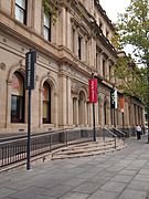
South Australia has three public universities and four private ones. The public universities are the University of Adelaide (founded 1874), Flinders University (founded 1966), and the University of South Australia (founded 1991).

The University of Adelaide is one of Australia's top research universities. It was the first Australian university to allow women to study in 1881. Adelaide is also the birthplace of three Nobel Prize winners.
Adelaide is home to many research centers. These include the Royal Institution of Australia and the South Australian Health and Medical Research Institute (SAHMRI). Many research groups are located in the Adelaide area. They work on things like plant research, wine research, and defense technology.
-
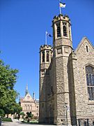
The Mitchell Building and Bonython Hall, University of Adelaide
-
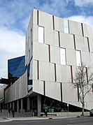
The Hawke Building, part of the UniSA, City West Campus
-
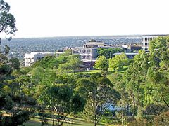
Flinders University buildings from the campus hills
-
Torrens University
-
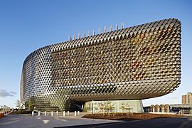
The South Australian Health and Medical Research Institute (SAHMRI)


Vocational Training
Vocational education helps people learn practical skills for jobs. This training is offered by various organizations. The largest public provider is TAFE South Australia. TAFE has colleges across the state, including in rural areas. They offer many courses to help people get ready for work.
People and Cultures
| Birthplace | Population |
|---|---|
| Australia | 1,192,546 |
| England | 97,392 |
| India | 27,594 |
| China | 24,610 |
| Italy | 18,544 |
| Vietnam | 14,337 |
| New Zealand | 12,937 |
| Philippines | 12,465 |
| Scotland | 11,993 |
| Germany | 10,119 |
| Greece | 8,682 |
| Malaysia | 7,749 |
| South Africa | 6,610 |
| Afghanistan | 6,313 |


As of December 2021, South Australia had 1,806,599 people. Most of them live in Greater Adelaide, which had about 1,333,927 people in June 2017. Other important towns include Mount Gambier (29,505), Victor Harbor-Goolwa (26,334), and Whyalla (21,976).
Ancestry and New Arrivals
In 2016, the most common backgrounds people identified with were:
- English (40.5%)
- Australian (35.5%)
- Scottish (8.9%)
- Irish (8.5%)
- German (8.2%)
- Italian (6.1%)
- Chinese (3.3%)
- Greek (2.4%)
- Indian (2.1%)
- Indigenous (2%)
- Dutch (1.7%)
- Vietnamese (1.3%)
- Polish (1.2%)
- Filipino (1%)
About 28.9% of the population was born outside Australia in 2016. The largest groups came from England (5.8%), India (1.6%), China (1.5%), Italy (1.1%), and Vietnam (0.9%). About 2% of the population identified as Indigenous Australians (Aboriginal Australians and Torres Strait Islanders).
Languages Spoken
In 2016, 78.2% of people spoke only English at home. Other common languages were Italian (1.7%), Standard Mandarin (1.7%), Greek (1.4%), Vietnamese (1.1%), and Cantonese (0.6%).
Religious Beliefs
In 2016, about 53.9% of people identified as Christian. About 9% chose not to state a religion. The most common responses were 'No Religion' (35.4%), Catholicism (18%), Anglicanism (10%), and Uniting Church (7.1%).
South Australia was the first Australian colony without an official state religion. This made it attractive to people who had faced religious unfairness. These included Methodists and Unitarians. Thousands of Prussian Old Lutheran immigrants also came. South Australia was home to Australia's first Muslim mosque. Adelaide has been known as the "City of Churches" since at least 1868.
Getting Around South Australia

Historical Journeys
After settlement, ocean travel was the main way to get around South Australia. Horses and bullocks provided limited land transport. In the mid-1800s, the state started building a large rail network. Coastal shipping continued until after World War II. Roads began to get better with the invention of cars. By the late 1800s, road transport was the main way to travel within South Australia.
Trains and Planes
South Australia has four train connections to other states. You can travel to Perth across the Nullarbor Plain. There's also a line to Darwin through the center of Australia. Trains also go to Broken Hill in New South Wales and to Melbourne.
Trains were very important for many mines in the north of the state. Adelaide has a local train network with six lines.
Adelaide Airport has regular flights to other capital cities and major South Australian towns. It also has daily flights to many international places.
Road Trips

South Australia has many roads connecting towns and other states. Cars are the most common way to get around in major cities. Public transport in Adelaide mostly uses buses and trams.
Water Travel

The River Murray used to be an important trade route. Paddle steamers linked inland areas to the ocean at Goolwa.
South Australia has a container port at Port Adelaide. There are also many other important ports along the coast for minerals and grains. The passenger terminal at Port Adelaide also welcomes cruise ships. Kangaroo Island relies on a ferry service between Cape Jervis and Penneshaw.
Fun Things to Do
South Australia has been called "the Festival State" for many years. It has lots of arts and food festivals. While many arts events are in Adelaide, the state government has also supported arts in regional areas.
South Australia has a public library system and a state library. Some public libraries in rural areas are shared with schools.
Sports Galore

Sports are very popular in South Australia!
- Australian Rules Football: This is the most popular sport to watch. South Australia has two teams in the Australian Football League (AFL): the Adelaide Football Club and Port Adelaide Football Club. These two teams have a big rivalry called the Showdown. Both teams play their home games at Adelaide Oval. The South Australian National Football League (SANFL) is a popular local league with ten teams.
- Cricket: Cricket has a long history here, starting in 1839. It's the most popular summer sport. The men's state team is the West End Redbacks. The women's team is the South Australian Scorpions. South Australia also has the Adelaide Strikers teams in the Big Bash League. International cricket matches are played at Adelaide Oval.
- Soccer: Adelaide United represents South Australia in men's and women's soccer leagues. Their home ground is Hindmarsh Stadium. The club won the A-League championship in 2015–16. Adelaide City is South Australia's most successful club. They have won many titles, including the 1987 Oceania Club Championship.
- Basketball: Basketball is also popular. The Adelaide 36ers play in the National Basketball League. They have won four championships. The Adelaide Entertainment Centre is the main place for basketball in the state.
- Motorsport: South Australia hosts the Supercars Championship every year. The Adelaide 500 race takes place on a temporary track in the streets of Adelaide. This track also hosted the Australian Grand Prix for Formula One from 1985 to 1995. There are also permanent race tracks like Mallala Motor Sport Park and The Bend Motorsport Park.
- Other Sports: Many South Australian children take part in organized sports. The Adelaide International tennis tournament is held here. The Royal Adelaide Golf Club has hosted the Australian Open golf tournament. The state has also hosted the Tour Down Under cycle race since 1999.

Places to Explore
|
Regions
Rivers
|
Lakes
Islands |
Main highways
|
Images for kids
-
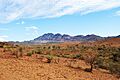
Arid land in the Flinders Ranges
-
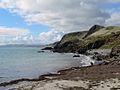
The rugged coastline of Second Valley, located on the Fleurieu Peninsula


See also
 In Spanish: Australia Meridional para niños
